Birkhouse Moor

Last updated
Birkhouse Moor
Birkhouse Moor.jpg
Striding Edge and Birkhouse Moor (right)
from St Sunday Crag
Highest point
Elevation 718 m (2,356 ft)
Prominence c. 20 m
Parent peak Helvellyn
Listing Wainwright, Nuttall
Coordinates 54°32′07″N2°59′04″W / 54.53526°N 2.98441°W / 54.53526; -2.98441 Coordinates: 54°32′07″N2°59′04″W / 54.53526°N 2.98441°W / 54.53526; -2.98441
Geography
Lake District National Park UK relief location map.png
Red triangle with thick white border.svg
Birkhouse Moor
Location in Lake District, UK
Location Cumbria, England
Parent range Lake District, Eastern Fells
OS grid NY364160
Topo map OS Explorer OL5

Birkhouse Moor is a fell in the English Lake District, an outlier of the Helvellyn range in the Eastern Fells. It is properly an eastern ridge of Helvellyn, but was treated as a separate fell by Alfred Wainwright in his Pictorial Guide to the Lakeland Fells . That convention is followed here.

Contents

Topography

Running east from the summit of Helvellyn is Striding Edge, a knife-edged arête which provides the most famous fell-walking in the District. The ridge turns a little to the north at the rocky turret of High Spying How and then drops to a grassy saddle, known as Hole-in-the-Wall. North east of here the ridge broadens into a wide plateau, appearing in plan like a three taloned claw. This plateau, about a mile wide, is Birkhouse Moor. The three talons are the short spurs of Keldas, The Nab and the unnamed northern ridge.

To the south of the Striding Edge–Birkhouse Moor ridge runs the long valley of Grisedale, emptying into the head of Ullswater. There are small pockets of mixed woodland on the lower slopes and above these the valley wall is steep sided with some outcropping rock.

Map showing Birkhouse Moor and surrounding area from 1925. Birkhouse Moor Map.jpg
Map showing Birkhouse Moor and surrounding area from 1925.

The northern side of Birkhouse Moor is bounded by the more complex Glenridding valley system. Glenridding Beck has three principal southern tributaries: Mires Beck, Bleacove Beck and Red Tarn Beck. Mires Beck flows from Little Cove, a small corrie separating Keldas and the Nab. Bleacove Beck empties Blea Cove, a short side valley between The Nab and the north ridge. Red Tarn Beck forms the western perimeter of Birkhouse Moor, draining the large tarn of that name nestling beneath the summit of Helvellyn. There is more rock on this side, with Nab Crag rising above Blea Cove and extensive outcropping on all three ridges. There remains evidence on the Glenridding slopes of the former activities of Greenside Mine. Several leats and pipelines can still be traced which once captured the water of these streams for industrial use.

Keldas is separated from the main body of Birkhouse Moor by a small depression containing Lanty’s Tarn. This small waterbody gains its name from Lancelot Dobson, an earlier landowner. It was later bought by the owners of Patterdale Hall, the Marshall family, and extended by damming. In addition to fishing, the tarn was used as a source of ice in winter, and the ice house still stands nearby. [1] The summit of Keldas is privately owned but public access is permitted. Standing above the head of Ullswater it provides superb views down the lake, with the ‘Keldas Pines’ giving an excellent foreground for pictures. [2]

Geology

The summit area is composed of the dacitic lapilli-tuff of the Helvellyn Formation. The overlying volcaniclastic sandstone of the Deepdale Formation is revealed at Keldas. [3]

Summit

Birkhouse Moor has two summits. The true top is on the main ridge to Striding Edge, which is followed by a stone wall. A cairn has been built a little to the west, but the wall appears to cross the highest point. The north top (2,315 ft) lies a quarter of a mile away at the meeting point of The Nab and the north ridge. A cairn has also been built here and there are good views to the north. Between the two tops is an area of marshy ground with a number of small tarns.

Ascents

Acting as a staging post on the popular ascent of Helvellyn from Patterdale, Birkhouse Moor is crossed by a number of major routes. The ridge can be gained from the Glenridding side via Mires Beck or Lanty’s Tarn. From the mouth of Grisedale a path climbs to the Hole-in-the-Wall, with variations allowing the summit to be visited or bypassed. Pathless climbs can also be made up The Nab or the north ridge from Glenridding. The view from the true summit is dominated by Helvellyn and the encircling arms of Striding and Swirral Edges. [4]

Related Research Articles

Helvellyn Mountain in the English Lake District

Helvellyn is a mountain in the English Lake District, the highest point of the Helvellyn range, a north–south line of mountains to the north of Ambleside, between the lakes of Thirlmere and Ullswater.

Fairfield (Lake District)

Fairfield is a fell in the English Lake District. It is the highest of a group of hills in the Eastern Fells, standing to the south of the Helvellyn range.

Catstye Cam

Catstye Cam is a fell in the English Lake District. It is an outlier of Helvellyn in the Eastern Fells.

Place Fell

Place Fell is a hill in the English Lake District. It stands at the corner of the upper and middle reaches of Ullswater, with steep western flanks overlooking the villages of Glenridding and Patterdale.

Nethermost Pike

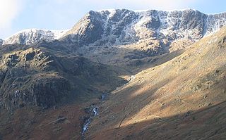
Nethermost Pike is a fell in Cumbria, England, and a part of the Lake District. At 891 metres (2,923 ft) it is the second highest Wainwright in the Helvellyn range, the highest of which is Helvellyn itself. It is located close to the southern end of the ridge, with Helvellyn to the north, and High Crag and Dollywaggon Pike to the south. Nethermost Pike, along with many of the Eastern Fells, lies between Thirlmere in the west and the Ullswater catchment in the east. The closest villages are Glenridding and Patterdale on the shores of Ullswater, over 8 kilometres (5 mi) away.

Raise (Lake District)

Raise is a fell in the English Lake District. It stands on the main spine of the Helvellyn range in the Eastern Fells, between Thirlmere and Ullswater.

St Sunday Crag

St Sunday Crag is a fell in the English Lake District, part of the Fairfield group in the Eastern Fells. It is a prominent feature in the Patterdale skyline, with a distinctive rounded shape. Indeed, it figures so finely in views from the upper reach of the lake that it is sometimes referred to as ‘the Ullswater Fell’.

White Side

White Side is a fell in the English Lake District. It is situated to the east of Thirlmere and to the west of Glenridding valley. This places White Side in the Helvellyn range of the Eastern Fells, with Raise to the north and Helvellyn Lower Man to the south, both of which are of greater height.

Dollywaggon Pike

Dollywaggon Pike is a fell in the English Lake District. It stands on the main spine of the Helvellyn range in the Eastern Fells, between Thirlmere and the Ullswater catchment.

The Helvellyn range is the name given to a part of the Eastern Fells in the English Lake District, "fell" being the local word for "hill". The name comes from Helvellyn, the highest summit of the group.

Patterdale Human settlement in England

Patterdale is a small village and civil parish in the eastern part of the English Lake District in the Eden District of Cumbria, in the traditional county of Westmorland, and the long valley in which they are found, also called the Ullswater Valley. The parish had a population of 460 in 2001, increasing to 501 at the 2011 Census.

Rest Dodd

Rest Dodd is a fell in the English Lake District. It is situated in the quieter far eastern region of the national park and reaches a height of 696 metres (2,283 feet). Rest Dodd is a fell that is often by-passed by walkers as they travel the busy footpath between Ullswater and Haweswater either to climb the more significant fell of High Street or strive to complete Alfred Wainwright’s Coast to Coast Walk. Indeed Wainwright describes Rest Dodd as “A fell of little interest although the east flank falls spectacularly in fans of colourful scree”. The fell is usually climbed in conjunction with other nearby "Wainwright" fells such as The Nab, Brock Crags and Angletarn Pikes.

Angletarn Pikes

Angletarn Pikes is a fell in the English Lake District near the village of Patterdale. Its most notable feature is the summit tarn from which it derives its name.

Seat Sandal

Seat Sandal is a fell in the English Lake District, situated four kilometres north of the village of Grasmere from where it is very well seen. Nevertheless, it tends to be overshadowed by its more illustrious neighbours in the Eastern Fells, Helvellyn and Fairfield.

Sheffield Pike

Sheffield Pike is a fell in the English Lake District, a prominent intermediate top on one of the eastern ridges of Stybarrow Dodd. It separates and stands high above the Glencoyne and Glenridding valleys, on the eastern side of the Helvellyn range in the Eastern Fells and it looks down onto Ullswater.

Glenridding Dodd

Glenridding Dodd is a small fell in the English Lake District, at the end of a ridge descending from the Helvellyn range in the Eastern Fells. It stands above the village of Glenridding and on the western shore of Ullswater. Although small and not of great elevation, its top is a fine viewpoint for Ullswater and for the fells clustered round the valleys above Patterdale.

Arnison Crag

Arnison Crag is a fell in the English Lake District, an outlier of the Fairfield group in the Eastern Fells. It looks down on Patterdale village and the upper reach of Ullswater.

Eastern Fells

The Eastern Fells are a group of hills in the English Lake District. Centred on Helvellyn they primarily comprise a north–south ridge running between Ullswater and Lakeland's Central Valley.

Far Eastern Fells

The Far Eastern Fells are a group of hills in the English Lake District. Reaching their highest point at High Street they occupy a broad area to the east of Ullswater and Kirkstone Pass. Much quieter than the central areas of Lakeland they offer in general easier but less exciting walking as the fells merge mainly into the surrounding moorlands. Exceptions however are the fine rock scenery to be seen on Harter Fell, Mardale Ill Bell and High Street surrounding the head of Haweswater

High Crag (Helvellyn)

High Crag is a minor fell on the Helvellyn Range in the eastern region of the English Lake District. It sits on the ridge to the south of Helvellyn and Nethermost Pike. It rises sharply above the head of Ruthwaite Cove, and has attracted the attention of rock climbers. Its rock type is a lapilli-tuff of the Helvellyn Tuff Formation.

References

  1. Blair, Don: Exploring Lakeland Tarns: Lakeland Manor Press(2003) ISBN   0-9543904-1-5
  2. Richards, Mark:Near Eastern Fells:Collins (2003) ISBN   0-00-711366-8
  3. British Geological Survey: 1:50,000 series maps, England & Wales Sheet 29: BGS (1999)
  4. Alfred Wainwright: A Pictorial Guide to the Lakeland Fells , Book 1: ISBN   0-7112-2454-4