Dove Crag

Last updated

Dove Crags
Dove Crags from High Hartsop Dodd.jpg
Dove Crag from High Hartsop Dodd, 2 km to the east
Highest point
Elevation 792 m (2,598 ft)
Prominence 50 m (160 ft)
Parent peak Hart Crag
Listing Hewitt, Wainwright, Nuttall
Coordinates 54°29′06″N2°58′04″W / 54.48506°N 2.96777°W / 54.48506; -2.96777
Geography
Lake District National Park UK relief location map.png
Red triangle with thick white border.svg
Dove Crags
Location in Lake District, UK
Location Cumbria, England
Parent range Lake District, Eastern Fells
OS grid NY374104
Topo map OS Landranger 90 OS Explorer Outdoor Leisure 5, 7

Dove Crag is a fell in the English Lake District. Situated in the Eastern Fells of the national park, seven kilometres south-south-west of Glenridding, it reaches a height of 792 metres (2,598 feet). The fell is often climbed as part of the Fairfield horseshoe walk but a direct ascent from Patterdale is required to show the fell's full potential, displaying the impressive crags just to the north east of the summit. The highest point was originally unnamed on maps, being just a minor top, but over the years the summit has adopted the name of Dove Crag by mutual accord..

Contents

Wainwright's Pictorial Guides

One of Dove Crag's claims to fame is that it was the first chapter ever written by Alfred Wainwright for his Pictorial Guide to the Lakeland Fells. He wrote the Dove Crag chapter on 9 November 1952 as he started Book One, after ascending the fell from Ambleside in the previous weeks, making notes and taking photographs. It would take Wainwright a further 14 years to finish the complete series of seven books and 214 fells.

Topography

The Fairfield Group of fells stands between Grasmere and the Kirkstone Pass. The watershed runs south east from Fairfield, crossing Hart Crag, Dove Crag, Little Hart Crag and Red Screes. Dove Crag shows its unassuming back to Rydal in the west, while great crags command the head of Dovedale on the opposite side of the ridge. A lower tier of crags juts out into the valley with Stangs at its head, dividing Dovedale Beck from its main tributary, Hogget Gill.

Dove Crag throws out a southern ridge which descends over High Pike and Low Pike towards Ambleside.

Geology

The volcaniclastic sandstone of the Deepdale Formation is interleaved with andesite sills and breccia. [1]

Rock climbing

The crags of Dove Crag are the fell's finest feature. The crag is about 75 metres (246 feet) high at its highest point and is a popular venue for rock climbers with classic routes such as Extol and Fast and Furious. Lately it has become used by boulderers with several top-class climbs such as Impailed and Pail Attitude on the boulders that have become detached from the main crag. Concealed within the crags is the “Priest's Hole”. This is a cave, roughly about five metres deep with extra protection provided by a wall built in front, which is often used by walkers and climbers as a rough overnight camp. It is well used and stocked (even having a visitors' book) but it is not easy to find in bad conditions. It is marked on the large-scale Ordnance Survey maps but this is only of limited use. It is not mentioned by Alfred Wainwright in his Pictorial Guide to the Lakeland Fells, which suggests that he did not know of its existence. The cave featured in the BBC One series Secret Britain in spring 2016. [2]

Ascents

As mentioned earlier, the majority of the people who climb Dove Crag do so from Ambleside as part of the Fairfield horseshoe walk. However, the ascent from Patterdale gives the walker the opportunity to explore the relatively unknown valley of Dovedale and the beck which flows down it and to study the crags of the fell. It is believed that the upper part of Dovedale was once the crater of a volcano. The ascent from Patterdale starts from the car park at Brothers Water and takes the path to Hartsop Hall. Here the rising path up Dovedale is taken. As the crags are approached at the head of the valley, there is a choice of going to the right or left of them to reach the summit. The fell can also be approached from Ambleside along its long southern ridge passing over the tops of Low Pike and High Pike. The summit is a small rock platform with a cairn.

Summit

A dry stone wall crosses the summit 15 metres to the west and this runs north to south to the adjoining fells of High Pike (south) and Hart Crag (north). The highlight of the summit view is obtained by walking to the edge of the crags and looking down into Dovedale.

Related Research Articles

<span class="mw-page-title-main">Fairfield (Lake District)</span> Fell in the English Lake District

Fairfield is a fell in the English Lake District. It is the highest of a group of hills in the Eastern Fells, standing to the south of the Helvellyn range.

<span class="mw-page-title-main">Nethermost Pike</span> Fell in Cumbria, England

Nethermost Pike is a fell in Cumbria, England, and a part of the Lake District. At 891 metres (2,923 ft) it is the second highest Wainwright in the Helvellyn range, the highest of which is Helvellyn itself. It is located close to the southern end of the ridge, with Helvellyn to the north, and High Crag and Dollywaggon Pike to the south. Nethermost Pike, along with many of the Eastern Fells, lies between Thirlmere in the west and the Ullswater catchment in the east. The closest villages are Glenridding and Patterdale on the shores of Ullswater, over 8 kilometres (5 mi) away.

<span class="mw-page-title-main">St Sunday Crag</span> Mountain in the English Lake District

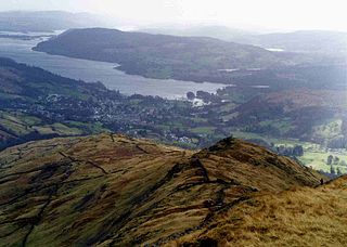
St Sunday Crag is a fell in the English Lake District, part of the Fairfield group in the Eastern Fells. It is a prominent feature in the Patterdale skyline, with a distinctive rounded shape. Indeed, it figures so finely in views from the upper reach of the lake that it is sometimes referred to as ‘the Ullswater Fell’.

<span class="mw-page-title-main">Stony Cove Pike</span> Mountain in the English Lake District, Cumbria, England

Stony Cove Pike is a fell in the Far Eastern part of the English Lake District. It stands on the other side of the Kirkstone Pass from Red Screes, and is on the end of a ridge coming down from High Street. It is separated from its neighbours by the deep col of Threshthwaite Mouth, so is a Marilyn – the sixteenth highest in the Lake District.

<span class="mw-page-title-main">Fairfield horseshoe</span>

Fairfield Horseshoe is a classic circular hillwalking ridge walk route starting from Rydal or Ambleside in the English Lake District that takes in all the fells that surround the valley of the Rydal Beck.

<span class="mw-page-title-main">Angletarn Pikes</span> Fell in the Lake District, Cumbria, England

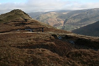
Angletarn Pikes is a fell in the English Lake District near the village of Patterdale. Its most notable feature is Angle Tarn from which it derives its name.

<span class="mw-page-title-main">Yoke (Lake District)</span> Fell in the Lake District, Cumbria, England

Yoke is a fell in the Lake District in Cumbria, England. It has a height of 706 metres (2,316 ft) and is situated in the far eastern sector of the national park, 6+12 kilometres ENE of the town of Ambleside. Yoke is the southern extremity of the long ridge that runs southwards from the fell of High Street. Yoke’s name is believed to be derived from the Old English language word geoc which is similar to the German word joch meaning mountain ridge.

<span class="mw-page-title-main">Shipman Knotts</span>

Shipman Knotts is a fell in the English Lake District in Cumbria, England. It reaches a height of 587 metres (1,926 ft) and is situated in one of the quieter areas of the national park, 2 kilometres north-east of Kentmere village. Although not one of the best-known Lake District fells, it earned a separate chapter in Alfred Wainwright’s Pictorial Guide to the Lakeland Fells due to “Its characteristic roughness. .. rocky outcrops are everywhere on its steep slopes”.

<span class="mw-page-title-main">Low Pike</span>

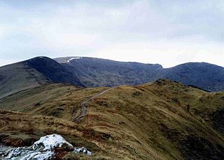
Low Pike is a small fell in the English Lake District. It has a modest height of 508 m (1,667 ft) and is situated three kilometres north of Ambleside. Low Pike is well seen from the streets of the town as the first prominent fell on the ridge which continues northwards for a further four kilometres to Fairfield. This ridge is part of the Fairfield horseshoe walk and Low Pike is most commonly ascended as part of this.

<span class="mw-page-title-main">High Pike (Scandale)</span>

High Pike is a fell in the English Lake District, located five kilometres north of Ambleside. Situated in the Eastern Fells, it can be confused with another Lake District High Pike in the Northern Fells. High Pike reaches a height of 656 metres (2,152 ft). It is sometimes referred to as Scandale Fell, although this name really only applies to the high ground at the head of Scandale.

<span class="mw-page-title-main">Heron Pike</span>

Heron Pike is a fell in the English Lake District, two kilometres east of Grasmere. It is part of the Fairfield group in the Eastern Fells. It should not be confused with the Heron Pike that forms part of Sheffield Pike, although it appears that, by coincidence, both Heron Pikes are exactly the same height.

<span class="mw-page-title-main">Little Hart Crag</span>

Little Hart Crag is a fell in the Lake District area of England. It stands at the head of Scandale, six kilometres north of Ambleside, at a height of 637 metres (2,090 ft). It is an eastern outlier of Dove Crag in the Eastern Fells, although it does have 34 metres (112 ft) of prominence from that fell making it both a Hewitt and a Nuttall fell. It is frequently climbed as part of the Dovedale horseshoe, an 11-kilometre (7-mile) walk over the neighbouring fells of Hartsop above How, Hart Crag, Dove Crag and High Hartsop Dodd, starting and finishing at Brothers Water.

<span class="mw-page-title-main">Great Rigg</span>

Great Rigg is a fell in the English Lake District, 7 kilometres north-west of Ambleside and reaching a height of 766 metres. It is most often climbed as part of the Fairfield horseshoe, a 16-km circular walk which starts and finishes in Ambleside. The fell's name originates from the Old English "Rigg", meaning a bumpy or knobbly ridge.

<span class="mw-page-title-main">Hart Crag</span> Fell in the Lake District, Cumbria, England

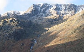
Hart Crag is a fell in the English Lake District, being one of the Fairfield group of hills in the Eastern Fells.

<span class="mw-page-title-main">Hartsop above How</span>

Hartsop above How is a fell in the English Lake District, an outlier of the Helvellyn range in the Eastern Fells. It stands above Brothers Water and the Ullswater–Ambleside road.

<span class="mw-page-title-main">High Hartsop Dodd</span>

High Hartsop Dodd is a fell in the English Lake District, an outlier of the Fairfield group in the Eastern Fells. It stands above Kirkstone Pass on the road from Ullswater to Ambleside.

<span class="mw-page-title-main">Nab Scar</span> Mountain in the English Lake District, Cumbria, England

Nab Scar is a fell in the English Lake District, an outlier of the Fairfield group in the Eastern Fells. It stands above Rydal Water.

<span class="mw-page-title-main">Arnison Crag</span>

Arnison Crag is a fell in the English Lake District, an outlier of the Fairfield group in the Eastern Fells. It looks down on Patterdale village and the upper reach of Ullswater.

<span class="mw-page-title-main">Eastern Fells</span>

The Eastern Fells are a part of the Cumbrian Mountains in the Lake District of England. Centred on Helvellyn they primarily comprise a north–south ridge running between Ullswater and Lakeland's Central Valley.

<span class="mw-page-title-main">Far Eastern Fells</span> Mountain range in Cumbria, England

The Far Eastern Fells are a part of the Cumbrian Mountains in the Lake District of England. Reaching their highest point at High Street, they occupy a broad area to the east of Ullswater and Kirkstone Pass. Much quieter than the central areas of Lakeland they offer in general easier walking as the fells merge mainly into the surrounding moorlands.

References

  1. British Geological Survey: 1:50,000 series maps, England & Wales Sheet 29: BGS (1999)
  2. McHale, John (16 October 2016). "Man falls 500ft to his death as Lakeland walkers head for night at Priest's Hole". Grough. Retrieved 21 October 2016.