
Northumberland is a county in North East England, and one of two counties in England which border with Scotland. A predominately rural county, Northumberland is the most sparsely-populated county in England. It is bordered by the Scottish Borders region to the north, the North Sea to the east, County Durham and Tyne and Wear to the south, and Cumbria to the west. The historic county town is Morpeth. The county is noted for its undeveloped landscape of high moorland, now largely protected as the Northumberland National Park. The North Sea to the east of the county runs 103 kilometres (64 mi) along its coastline. Lying south of the Anglo-Scottish border, Northumberland has been the site of a number of historic battles.

Northumberland National Park is the northernmost national park in England. It covers an area of more than 1,050 square kilometres (410 sq mi) between the Scottish border in the north to just south of Hadrian's Wall, and it is one of the least populated and least visited of the National Parks. The park lies entirely within Northumberland, covering about a quarter of the county.

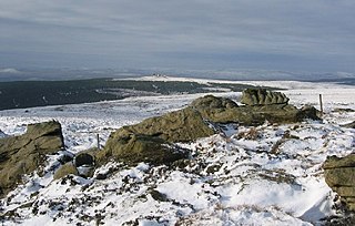
A fell is a high and barren landscape feature, such as a mountain or moor-covered hill. The term is most often employed in Norway, Fennoscandia, Iceland, the Isle of Man, parts of northern England, and Scotland.

Kielder Forest is a large forestry plantation in Northumberland, England, surrounding Kielder village and the Kielder Water reservoir. It is the largest man-made woodland in England with three-quarters of its 250 square miles (650 km2) covered by forest. The majority of the forest lies within Kielder Water and Forest Park, with the southern tip known as Wark Forest lying within Northumberland National Park.
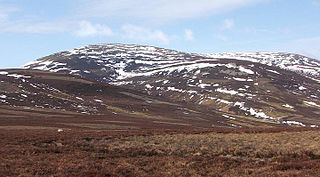
The Cheviot is an extinct volcano and the highest summit in the Cheviot Hills and in the county of Northumberland. Located in the extreme north of England, it is 1+1⁄4 miles from the Scottish border and, with a height of 2,674 feet above sea-level, is located on the northernmost few miles of the Pennine Way, before the descent into Kirk Yetholm.

Butteryhaugh is a village in Northumberland, in England. It is situated a short distance to the south-east of Kielder.
Redesdale is a valley in the western part of the county of Northumberland, in northeast England. This area contains the valley of the River Rede, a tributary of the River North Tyne.

Kielder is a small, remote village in western Northumberland, England. Located at the head of Kielder Water and in the north west of Kielder Forest, the village is within three miles of the Scottish border.

The Rede is a river in Northumberland, England. The river rises on Carter Fell on the Anglo-Scottish border feeding Catcleugh Reservoir and joins the River North Tyne below the village of Redesmouth. The Rede is one of only two rivers in the North East of England that has the freshwater pearl mussel in its waters.
A fell is a mountain or upland area in northern England and other parts of Europe.

The Anglo-Scottish border is a border separating Scotland and England which runs for 96 miles (154 km) between Marshall Meadows Bay on the east coast and the Solway Firth in the west. The surrounding area is sometimes referred to as "the Borderlands".

The mountains and hills of England comprise very different kinds of terrain, from a mountain range which reaches almost 1,000 metres high, to several smaller areas of lower mountains, foothills and sea cliffs. Most of the major upland areas have been designated as Areas of Outstanding Natural Beauty (AONB) or national parks. The highest and most extensive areas are in the north and west, while the midlands, south-east and east of the country tend to be low-lying.
Sighty Crag is a hill in the southern part of the Kielder Forest region in northern England, a region which also includes its fellow Marilyns of Peel Fell and Larriston Fells. It is separated from its higher and more shapely counterpart, Peel Fell, by the low valley in which sits the village of Kielder.
Bakethin Reservoir is a reservoir immediately upstream of Kielder Water, in Northumberland, England, close to the border with Scotland. It is fed by the River North Tyne and lies southeast of Kielder village.

Kielder Observatory is an astronomical observatory located in Kielder Forest, Northumberland, England. It is situated high upon Black Fell overlooking Kielder Water near the Scottish border, and half a mile up a forest track from James Turrell's Kielder Skyspace. The site was chosen due to its pristine night skies in a location free of light pollution with clear views to all horizons, and is one of the best places in the UK to view the Milky Way.
Deadwater is a small settlement in Northumberland, England, about 3 miles (5 km) north west of Kielder, Northumberland, on the English side of the border between Scotland and England. It is regarded as the source of the River North Tyne, which merges with the River South Tyne near Hexham, and continues around 93 miles/150 km to the North Sea.

Saughtree is a hamlet in the Scottish Borders at the junction of the B6357 and an unnamed road from Kielder village in Northumberland, England. It is at the confluence of the River Liddle [Liddel Water] and Dawston Burn. The valley of the Liddle is known as Liddesdale. The nearest settlements on the B6357 are Bonchester Bridge, Newcastleton and Kielder village. It is approximately 6 km from the border with England.

The Cheviot Hills, or sometimes The Cheviots, are a range of uplands straddling the Anglo-Scottish border between Northumberland and the Scottish Borders. The English section is within the Northumberland National Park. The range includes The Cheviot, plus Hedgehope Hill to the east, Windy Gyle to the west, and Cushat Law and Bloodybush Edge to the south.
The geology of Northumberland in northeast England includes a mix of sedimentary, intrusive and extrusive igneous rocks from the Palaeozoic and Cenozoic eras. Devonian age volcanic rocks and a granite pluton form the Cheviot massif. The geology of the rest of the county is characterised largely by a thick sequence of sedimentary rocks of Carboniferous age. These are intruded by both Permian and Palaeogene dykes and sills and the whole is overlain by unconsolidated sediments from the last ice age and the post-glacial period. The Whin Sill makes a significant impact on Northumberland's character and the former working of the Northumberland Coalfield significantly influenced the development of the county's economy. The county's geology contributes to a series of significant landscape features around which the Northumberland National Park was designated.
Border Moors and Forests NCA is an upland plateau region in Northern England between the North East and North West regions, and touching the Anglo-Scottish border. The region, like much of the northern English uplands, is sparsely populated, with scattered farming and hardy shepherding in river valleys. Because of this sparse population, 39% of the region is part of the Northumberland National Park in the southeast and several military assets are placed here, both modern and ancient. The NCA is of lower elevation to the Cheviot Hills to the east. The A68 is the only main road going through the region. Conifer plantations, moorland, bogs, wet heaths make up the landscape of the region, which only allows for rough grazing of sheep in most areas outside of the valleys. Afforestation is a major environmental factor within the 20th and 21st centuries, as Fielder Forest is the largest planted forest in northern Europe and has destroyed many native mires and peat bogs of the region. As such in the 21st century preserving the moors has been a top priority in the region as its habitat is home to high biodiversity and the region also serves as an important storer of carbon in its moors.

