The Outlying Fells of Lakeland

Last updated

1st ed, 1974 Wainwright's The Outlying Fells of Lakeland, cover.jpg
1st ed, 1974

The Outlying Fells of Lakeland is a 1974 book written by Alfred Wainwright dealing with hills in and around the Lake District of England. It differs from Wainwright's Pictorial Guides in that each of its 56 chapters describes a walk, sometimes taking in several summits, rather than a single fell. This has caused some confusion on the part of authors attempting to prepare a definitive list of peaks. The Outlying Fells do not form part of the 214 hills generally accepted as making up the Wainwrights, but they are included in Category 2B of the Hill Walkers' Register maintained by the Long Distance Walkers Association. [1]

Contents

The book

The first edition was published in 1974 by The Westmorland Gazette . It was republished by Michael Joseph in 1992 ( ISBN   0718140087) and a second edition, revised by Chris Jesty, was published by the Wainwright Society in 2020 ( ISBN   9780993592126).

The first edition is uniform with the seven volumes of Wainwright's Pictorial Guides, with a yellow band at head and foot of the dustjacket. The wording on the cover, in Wainwright's characteristic handwritten style, is:

THE OUTLYING FELLS OF LAKELAND
being a Pictorial Guide
to the lesser fells
around the perimeter of Lakeland
written primarily for
old age pensioners and others
who can no longer climb high fells
but can still, within reason, potter
about on the short and easy slopes
and summits of the foothills.

Below this, there is a pen sketch showing an elderly but sprightly walker approaching the summit of a small hill, and Wainwright's signature.

Fells included

Beacon Fell, looking across Beacon Tarn Beaconfell.JPG
Beacon Fell, looking across Beacon Tarn

The arrangement of chapters in the book is clockwise starting in the south east, with the first chapter devoted to Scout Scar, a walk starting at Kendal Town Hall.

The list at the back of Wainwright's book contains 110 named fells and summits. Close inspection shows seven of them to refer to other hills in the list, while Newton Fell has two summits. Thus:

The addition of the 12 nameless summits brings the number of Wainwright's Outlying Fells to 116. This is 14 more than the 102 hills listed in John M. Turner's New Combined Indexes to A. Wainwright's Pictorial Guides (second edition, Lingdales Press, 1984). Turner's list omits two tops explicitly mentioned in the book (St. John's Hill and Newton Fell South) and the 12 nameless summits, and it contains many inaccuracies. [2]

A second edition of the book, revised by Chris Jesty, was published by Frances Lincoln in 2011 ( ISBN   978-0-7112-3175-7). It maintains the same format but uses red to highlight paths on the route diagrams, and includes updated content (e.g. for Staveley Fell where Jesty says (p. 49) "There must be many people who, encouraged ... by the first edition of this book, have turned left and ... been turned back by an uncrossable fence." before providing an alternative route.)

Highest and lowest

The highest three summits listed by Wainwright are:

The lowest summits are:

List of summits

The list below has been arranged in alphabetical order rather than height in order to align as far as possible with the list at the back of Wainwright's book. Summits are listed by the name used in the Database of British and Irish Hills, [3] with cross-references from other summit names used by Wainwright to the entries in this table. Each summit appears only once, with height and grid reference. The "page" column allows the list to be sorted into Wainwright's order of chapters, which is roughly geographical, moving clockwise round the area from Kendal in the east.

List of summits, sortable by height, relative height, chapter title and page number
SummitHeight
(m)
Relative
height
(m)
Grid ref.ChapterPage
Bannisdale Fell, Long Crag 49332 NY515054 The Bannisdale Horseshoe260
Beacon Fell 255128 SD278907 Beacon Fell98
Bigland Barrow 19323 SD363839 Bigland Barrow70
Black Combe 600362 SD135854 Black Combe162
Blawith Knott 24888 SD260884 Blawith Knott108
Boat How 33781 NY177034 Boat How178
Brant Fell 19165 SD409961 Brant Fell34
Brunt Knott 42721 NY484006 Potter Fell8
Buck Barrow 54972 SD151910 Whit Fell156
Burn Moor 54323 SD151924 Whit Fell156
Burney 298111 SD260858 Burney112
Caermote Hill 28959 NY196371 Caermote Hill206
Capplebarrow 51321 NY508035 The Bannisdale Horseshoe260
Carron Crag 31466 SD325943 Carron Crag88
Cartmel Fell see Raven's BarrowCartmel Fell42
Caw 529132 SD230944 Caw120
Claife Heights 270177 SD382973 Claife Heights80
Clints Crags 24510 NY159352 Clints Crags204
Cold Fell 29383 NY058092 Cold Fell196
Cunswick Scar 20737 SD491943 Scout Scar2
Dent 3455 NY037130 Flat Fell and Dent198
Dunmallet 24080 NY467246 Dunmallet214
Dunnerdale Fells 28012 SD207918 Dunnerdale Fells132
Faulds Brow 34426 NY299407 Faulds Brow210
Fewling Stones 50811 NY513117 Seat Robert236
Finsthwaite Heights 1800 SD361883 Finsthwaite Fell74
Flat Fell 27274 NY052137 Flat Fell and Dent198
The Forest, Bannisdale Horseshoe 352840 NY527035 The Bannisdale Horseshoe260
Grandsire 25180 SD432972 School Knott30
Great Ladstones 4401 NY532123 Seat Robert236
Great Saddle Crag 5602 NY526086 The Wet Sleddale Horseshoe242
Great Stickle 30527 SD211915 Stickle Pike126
Great Worm Crag 42732 SD193968 Great Worm Crag136
Great Yarlside 5916 NY525075 The Wasdale Horseshoe248
Green Pikes 4204 SD236950 Caw120
Gummer's How 321217 SD390884 Gummer's How44
Hampsfell 2201 SD399793 Hampsfell58
Hare Shaw 50313 NY497131 The Naddle Horseshoe224
Harper Hills 4144 NY510144 The Naddle Horseshoe224
Hesk Fell 477100 SD176946 Hesk Fell140
Heughscar Hill 37548 NY488231 Heughscar Hill216
High House Bank 49580 NY543048 The Crookdale Horseshoe254
High Knott 27556 NY454001 High Knott18
High Light Haw 26313 SD303904 Top o'Selside92
High Wether Howe 53166 NY515109 Seat Robert236
Hollow Moor, Green Quarter Fell42678 NY468039 Green Quarter Fell14
Hooker Crag see Muncaster FellMuncaster Fell186
Howes 5833 NY498103 Howes230
Hugh's Laithes Pike 4152 NY502151 The Naddle Horseshoe224
Hugill Fell 26511 SD462994 Hugill Fell22
Humphrey Head 5342 SD391738 Humphrey Head66
Irton Pike 22925 NY120015 Irton Pike182
Kinmont Buck Barrow 53525 SD146909 Whit Fell156
Knipescar Common, Knipe Scar3428 NY526191 Knipescar Common220
The Knott, Stainton Pike33121 SD143951 Stainton Pike150
The Knott, Stickle Pike28424 SD224919 Stickle Pike126
Lamb Pasture 36728 NY534021 The Bannisdale Horseshoe260
Langhowe Pike 40010 NY528134 Seat Robert236
Latterbarrow 24444 SD367991 Latterbarrow84
Little Yarlside 5169 NY530071 The Wasdale Horseshoe248
Long Crag see Bannisdale Fell, Long CragThe Bannisdale Horseshoe260
Lord's Seat, High House Fell52436 NY518066 The Crookdale Horseshoe254
Lord's Seat, Whitbarrow see WhitbarrowWhitbarrow36
Low Light Haw 25016 SD301900 Top o'Selside92
Muncaster Fell, Hooker Crag231194 SD112983 Muncaster Fell186
Nabs Moor 4922 NY503111 Howes230
Naddle High Forest, Naddle Horseshoe 143528 NY492143 The Naddle Horseshoe224
Newton Fell North 2390 SD395842 Newton Fell52
Newton Fell South, Dixon Heights17737 SD413815 Newton Fell52
Orrest Head 23863 SD414993 Orrest Head26
The Pike, Hesk Fell37072 SD186934 Hesk Fell140
Pikes 46941 SD237947 Caw120
Ponsonby Fell 31534 NY081070 Ponsonby Fell192
Raven's Barrow, Cartmel Fell1520 SD412879 Cartmel Fell42
Raven's Crag 36128 SD223929 Stickle Pike126
Reston Scar 25520 SD460988 Reston Scar24
Robin Hood 49330 NY530058 The Crookdale Horseshoe254
Rough Crag 31970 SD161977 The Circuit of Devoke Water144
St. John's Hill , Caermote Hill N top2857 NY196376 Caermote Hill206
Scalebarrow Knott 3389 NY519153 The Naddle Horseshoe224
School Knott 24732 SD428967 School Knott30
Scout Scar 2333 SD486919 Scout Scar2
Seat How, Birker Moor31158 SD165971 The Circuit of Devoke Water144
Seat Robert 51530 NY526114 Seat Robert236
Setmurthy Common see Watch Hill, Setmurthy CommonWatch Hill202
Sleddale Pike 5066 NY535094 The Wet Sleddale Horseshoe242
Stainton Pike 49820 SD152942 Stainton Pike150
Staveley Fell 26537 SD389868 Staveley Fell48
Stickle Pike 375116 SD212928 Stickle Pike126
Stoupdale Head 47226 SD151873 Black Combe162
Swinklebank Crag, Bannisdale Horseshoe 255446 NY500049 The Bannisdale Horseshoe260
Tarn Hill 31330 SD209921 Stickle Pike126
Todd Fell 40121 NY512020 The Bannisdale Horseshoe260
Top o'Selside 3345 SD308918 Top o'Selside92
Tottlebank Height 23626 SD269885 Blawith Knott108
Ulgraves 33331 SD511996 Potter Fell8
Ulthwaite Rigg 5022 NY514093 The Wet Sleddale Horseshoe242
Wallow Crag, Naddle Horseshoe 243529 NY496149 The Naddle Horseshoe224
Walna Scar 62115 SD257963 Walna Scar114
Wasdale Pike 5655 NY536084 The Wasdale Horseshoe248
Watch Hill 2353 NY149318 Watch Hill202
Watch Hill, Setmurthy Common 254157 NY159318 Watch Hill202
Water Crag 30537 SD153974 The Circuit of Devoke Water144
Whatshaw Common 48566 NY541061 The Wasdale Horseshoe248
Whitbarrow (Lord's Seat)215182 SD441870 Whitbarrow36
White Combe 4174 SD154862 Black Combe162
White Howe, Bannisdale53073 NY523041 The Bannisdale Horseshoe260
White Pike, Birkby Fell44217 SD150956 The Circuit of Devoke Water144
Whiteside Pike 39747 NY520015 The Bannisdale Horseshoe260
Whitfell 573221 SD158929 Whit Fell156
Williamson's Monument see High KnottHigh Knott18
Woodend Height 48711 SD156954 The Circuit of Devoke Water144
Wool Knott 22353 SD272896 Woodland Fell102
Yew Bank 20717 SD262909 Woodland Fell102
Yoadcastle 49457 SD156952 The Circuit of Devoke Water144
nameless, Bannisdale Horseshoe 1 see Swinklebank CragThe Bannisdale Horseshoe260
nameless, Bannisdale Horseshoe 2 - Ancrow Brow N54116 NY503059 The Bannisdale Horseshoe260
nameless, Bannisdale Horseshoe 3see The ForestThe Bannisdale Horseshoe260
nameless, Green Quarter Fell 41111 NY473042 Green Quarter Fell14
nameless, Naddle Horseshoe 1see Naddle High ForestThe Naddle Horseshoe224
nameless, Naddle Horseshoe 2see Wallow CragThe Naddle Horseshoe224
nameless, Naddle Horseshoe 33957 NY505152 The Naddle Horseshoe224
nameless, Potter Fell 139527 SD489998 Potter Fell8
nameless, Potter Fell 239045 NY496003 Potter Fell8
nameless, School Knott 24732 SD428967 School Knott30
nameless, Stickle Pike see Raven's CragStickle Pike126
nameless, Top o'Selside, Brock Barrow2213 SD298898 Top o'Selside92

Map

The map marks the highest point reached on each of Wainwright's 56 walks. The number adjacent to each point gives the page number of the corresponding chapter in the book and the colour indicates the general height of the summit. Clicking a number provides a link to the article about the fell in question.

Lake District National Park UK relief location map.png
Brown pog.svg
2
Purple pog.svg
8
Purple pog.svg
14
Brown pog.svg
18
Brown pog.svg
22
Brown pog.svg
24
Brown pog.svg
26
Brown pog.svg
30
Orange pog.svg
34
Brown pog.svg
36
Orange pog.svg
42
Black pog.svg
44
Brown pog.svg
48
Brown pog.svg
52
Brown pog.svg
58
Green pog.svg
66
Orange pog.svg
70
Orange pog.svg
74
Brown pog.svg
80
Brown pog.svg
84
Black pog.svg
88
Black pog.svg
92
Brown pog.svg
98
Brown pog.svg
102
Brown pog.svg
108
Brown pog.svg
112
Red triangle with thick white border.svg
114
Blue Fire.svg
120
Black pog.svg
126
Brown pog.svg
132
Purple pog.svg
136
Purple pog.svg
140
Purple pog.svg
144
Purple pog.svg
150
Blue Fire.svg
156
Fire.svg
162
Black pog.svg
178
Brown pog.svg
182
Brown pog.svg
186
Black pog.svg
192
Brown pog.svg
196
Black pog.svg
198
Brown pog.svg
202
Brown pog.svg
204
Brown pog.svg
206
Black pog.svg
210
Brown pog.svg
214
Black pog.svg
216
Black pog.svg
220
Blue Fire.svg
224
Blue Fire.svg
230
Blue Fire.svg
236
Blue Fire.svg
242
Blue Fire.svg
248
Blue Fire.svg
254
Blue Fire.svg
260
Fire.svg
over 600 metres
Blue Fire.svg
500–599 m
Purple pog.svg
400–499 m
Black pog.svg
300–399 m
Brown pog.svg
200–299 m
Orange pog.svg
100–199 m
Green pog.svg
less than 100 m
Numbers are page numbers in Wainwright's book
Location dot red.svg
Kendal
Location dot red.svg
Penrith
Location dot red.svg
Keswick
Location dot red.svg
Ambleside
Location dot red.svg
Grasmere
Location dot red.svg
Cockermouth
Location dot red.svg
Workington
Location dot red.svg
Whitehaven
Location dot red.svg
Grange-over-Sands
Blue pog.svg
Derwentwater
Blue pog.svg
Ullswater
Blue pog.svg
Windermere
Blue pog.svg
Coniston
Blue pog.svg
Wastwater
Blue pog.svg
Thirlmere
Blue pog.svg
Ennerdale
Blue pog.svg
Bassenthwaite
Blue pog.svg
Buttermere
Blue pog.svg
Crummock
Blue pog.svg
Haweswater
Wainwright's "Outlying Fells"

See also

Related Research Articles

Alfred Wainwright MBE, who preferred to be known as A. Wainwright or A.W., was a British fellwalker, guidebook author and illustrator. His seven-volume Pictorial Guide to the Lakeland Fells, published between 1955 and 1966 and consisting entirely of reproductions of his manuscript, has become the standard reference work to 214 of the fells of the English Lake District. Among his 40-odd other books is the first guide to the Coast to Coast Walk, a 182-mile (293-kilometre) long-distance footpath devised by Wainwright which remains popular today.

<span class="mw-page-title-main">Watch Hill (Cockermouth)</span> Hill in Cumbria, England

Watch Hill is a small hill lying on the north-western fringe of the Lake District in England. It has a height of 833 feet (254 m) and a prominence of 515 feet (157 m). The name Setmurthy Common is sometimes used to refer to the area including the highest point, with "Watch Hill" describing the area to the west of the summit. It should not be confused with another Watch Hill some 19 km to the south-west, near Whitehaven, which is only 172 m (564 ft) high. The name "The Hay" is also used when referring to the area west of the summit.

<span class="mw-page-title-main">Castle Crag</span> Hill in United Kingdom

Castle Crag is a hill in the North Western Fells of the English Lake District. It is the smallest hill included in Alfred Wainwright's influential Pictorial Guide to the Lakeland Fells, the only Wainwright below 1,000 feet (300 m).

<span class="mw-page-title-main">Black Combe</span> Mountain in the English Lake District, Cumbria, England

Black Combe is a fell in the south-west corner of the Lake District National Park, England, just 4 miles (6.4 km) from the Irish Sea. It lies near the west coast of Cumbria in the borough of Copeland and more specifically, in the ancient district of Millom. It is 1,970 ft (600 m) high and stands in isolation, some 10 mi (16 km) away from any higher ground; this factor offers an excellent all-round panoramic view of land and sea, weather permitting.

<i>Pictorial Guide to the Lakeland Fells</i> Area guide

A Pictorial Guide to the Lakeland Fells is a series of seven books by A. Wainwright, detailing the fells of the Lake District in northwest England. Written over a period of 13 years from 1952, they consist entirely of reproductions of Wainwright's manuscript, hand-produced in pen and ink with no typeset material.

<span class="mw-page-title-main">Stickle Pike</span> Mountain in the English Lake District, Cumbria, England

Stickle Pike is an outlying fell located in the southern Lake District near the small town of Broughton-in-Furness, with the summit situated between the lower Duddon Valley and the quiet smaller valley of Dunnerdale. Despite its low altitude the sharp, conical summit is prominent in views from the Broughton and high Furness areas. As with many of the Dunnerdale and Coniston fells, there are reminders of the area's former mining past in the form of many spoil heaps, disused levels and shafts. The fell is also notable for its wide-ranging views despite its low altitude, especially to the Scafells to the north and the sands of the Duddon Estuary to the south. A "stickle" is a hill with a prominent rocky top.

<span class="mw-page-title-main">Great Stickle</span>

Great Stickle is a fell located in the southern Lake District of England with an altitude of 305 m (1,001 ft). Alfred Wainwright included it in the Stickle Pike chapter of his "The Outlying Fells of Lakeland". Geographically the fell is located on the southern ridge of Stickle Pike and is located between the lower Duddon Valley (west) and the valley of Dunnerdale Beck (east). A "stickle" is a hill with a prominent rocky top.

<span class="mw-page-title-main">Shipman Knotts</span>

Shipman Knotts is a fell in the English Lake District in Cumbria, England. It reaches a height of 587 metres (1,926 ft) and is situated in one of the quieter areas of the national park, 2 kilometres north-east of Kentmere village. Although not one of the best-known Lake District fells, it earned a separate chapter in Alfred Wainwright’s Pictorial Guide to the Lakeland Fells due to “Its characteristic roughness. .. rocky outcrops are everywhere on its steep slopes”.

<span class="mw-page-title-main">Cartmel Fell</span> Hamlet and civil parish in Cumbria, England

Cartmel Fell is a hamlet and a civil parish in the South Lakeland district of Cumbria, England. In the 2001 census the parish had a population of 309, increasing at the 2011 census to 329. The village of Cartmel and Cartmel Priory are not in this parish but in Lower Allithwaite, to the south: Cartmel Fell church is about 7 miles north of Cartmel Priory.

<span class="mw-page-title-main">Potter Fell</span>

Potter Fell is a fell near the villages of Burneside and Staveley, Cumbria, England, reaching a maximum height of 1,400 feet (430 m) at Brunt Knott. Alfred Wainwright in his The Outlying Fells of Lakeland identifies four summits on Potter Fell: Brunt Knott, Ulgraves and two unnamed summits, all of which are thus recognised by the Database of British and Irish Hills. There are a number of tarns on the fell, including Gurnal Dubs and Potter Tarn.

<span class="mw-page-title-main">Reston Scar</span> Hill in Cumbria, England

Reston Scar is a fell in the Lake District of Cumbria, England. With a height of 837 feet (255 m), it overlooks the north side of Staveley village, and is listed among Alfred Wainwright's The Outlying Fells of Lakeland. The summit offers good views of the Coniston Fells, the Sca Fells and the Langdale Pikes.

<span class="mw-page-title-main">Caer Mote</span>

Caer Mote is a hill of 289 metres (948 ft) in the north of the English Lake District near Bothel, Cumbria. Its summit lies just outside the boundary of the Lake District National Park and offers a view of Bassenthwaite Lake. Under the name Caermote Hill it is the subject of a chapter of Wainwright's book The Outlying Fells of Lakeland. Wainwright's route is an ascent from Bothel to the northern summit St. John's Hill at 285 metres (935 ft), continuing south to the main summit and south east to meet a minor road beside the Roman fort and follow that road north for an anticlockwise circuit. In his original book Wainwright lists the height as 920 feet, but in the 2011 2nd edition Chris Jesty corrects this to 948 feet.

<span class="mw-page-title-main">School Knott</span>

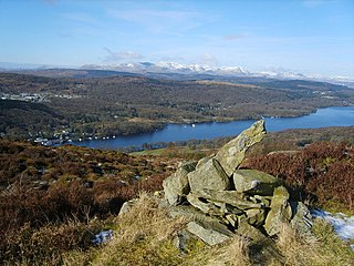
School Knott is a hill in the Lake District, England, to the east of Windermere town, Cumbria. It is the subject of a chapter of Wainwright's book The Outlying Fells of Lakeland. His recommended route starts at Windermere railway station and includes Grandsire at 818 feet (249 m) and a nameless summit at 806 feet (246 m). The summit is at 760 feet (230 m) and offers a view of four sections of Windermere, the lake. It has a rocky outcrop but no trig point and, as reported by Wainwright, no cairn. Schoolknott Tarn is to the south-east of the summit.

<span class="mw-page-title-main">Bannisdale Horseshoe</span>

The Bannisdale Horseshoe is an upland area in Cumbria, England, near the eastern boundary of the Lake District National Park, surrounding the valley of Bannisdale Beck, a tributary of the River Mint. It is described in the final chapter of Wainwright's book The Outlying Fells of Lakeland.

<span class="mw-page-title-main">Naddle Horseshoe</span>

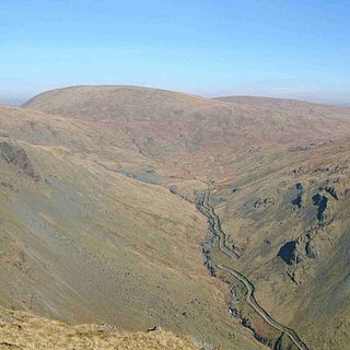
The Naddle Horseshoe is a group of summits in the English Lake District, south of Mardale valley, Cumbria. It is the subject of a chapter of Wainwright's book The Outlying Fells of Lakeland.

<span class="mw-page-title-main">Newton Fell</span> Hill in Cumbria, England

Newton Fell is a hill in the English Lake District near High Newton, south east of Newby Bridge, Cumbria. It lies to the north east of the A590 road. It is the subject of a chapter of Wainwright's book The Outlying Fells of Lakeland. Wainwright describes two walks, to the summits he calls Newton Fell (north) at 780 feet (240 m) and Newton Fell (south) or Dixon Heights at 585 feet (178 m). There are no public rights of way to either summit, and he states that the walks should be done "by courtesy of the owners and tenants".

<span class="mw-page-title-main">Hugill Fell</span> Hill in Cumbria, England

Hugill Fell is a hill in the English Lake District, near Staveley, Cumbria, on the western side of the Kentmere valley.

<span class="mw-page-title-main">Staveley-in-Cartmel</span> Human settlement in England

Staveley-in-Cartmel is a small village and civil parish in South Lakeland district, Cumbria, England. It lies east of Newby Bridge, near the south end of Windermere, 9 miles (14 km) northeast of Ulverston. It is sometimes known as Staveley-in-Furness. Both names distinguish it from another Staveley in Cumbria. In the 2001 census the parish had a population of 428, decreasing at the 2011 census to 405.

<span class="mw-page-title-main">Staveley Fell</span>

Staveley Fell is an upland area in the English Lake District, near Staveley-in-Cartmel, Cumbria, east of the southern end of Windermere. It is the subject of a chapter of Wainwright's book The Outlying Fells of Lakeland, but he admits that: "Strictly it has no name, not even locally, being referred to on Ordnance maps as Astley's and Chapel House Plantations, which are new forests severely encroaching upon it". He says it "commands a fine aerial view of the foot of Windermere." The fell reaches 870 feet (270 m) and Wainwright's route is a clockwise loop starting from Staveley-in-Cartmel. Chris Jesty in his revised edition of Wainwright's book provides an alternative route and comments that "There must be many people who, encouraged by the ordnance Survey map, or by the first edition of this book, have ... been turned back by an uncrossable fence."

References

  1. "Hillwalkers' Register 2". www.ldwa.org.uk. Long Distance Walkers Association . Retrieved 21 May 2020.
  2. For more up-to-date heights, grid references and other data, see the Database of British and Irish Hills
  3. "Version 12.1". Database of British and Irish Hills. Retrieved 24 May 2012.

Sources