| Flat Fell | |
|---|---|
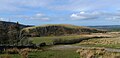
 Flat Fell from Dent | |
| Highest point | |
| Elevation | 272 m (892 ft) |
| Parent peak | Dent |
| Listing | Outlying Wainwright |
| Coordinates | 54°30′38″N3°27′56″W / 54.510482°N 3.465661°W |
| Geography | |
 Flat Fell | |
| OS grid | NY052137 |
Flat Fell is a hill located on the edge of the English Lake District, standing at 272m. It is included in Alfred Wainwright's Outlying Fells of Lakeland book, sharing a chapter with Dent. [1] Wainwright's clockwise route to the two summits starts at Wath Brow.