Kinniside Stone Circle

Last updated
Kinniside Stone Circle

Kinninside Stone Circle - geograph.org.uk - 1125881.jpg

Kinniside Stone Circle
Cumbria UK location map.svg
Archaeological site icon (red).svg
Shown within Cumbria
Location Cumbria
Coordinates 54°30′47″N3°27′10″W / 54.513013°N 3.452687°W / 54.513013; -3.452687 Coordinates: 54°30′47″N3°27′10″W / 54.513013°N 3.452687°W / 54.513013; -3.452687
Type Stone circle
History
Periods Neolithic? / Bronze Age?

Kinniside Stone Circle (or Blakeley Raise Stone Circle) is a reconstructed stone circle in the civil parish of Ennerdale and Kinniside in Cumbria, England (grid reference NY060140 ).

Stone circle monument of standing stones arranged in a circle

A stone circle is a circular alignment of standing stones. They are commonly found across Northern Europe and Great Britain and typically date from the Late Neolithic and Early Bronze Age eras, with most concentrations appearing from 3000 BC. The best known examples include those at the henge monument at Avebury, the Rollright Stones and elements within the ring of standing stones at Stonehenge. Ancient stone circles appear throughout Europe with many appearing in the Pyrenees, on the Causse de Blandas in southern France in the Cevennes, in the Alps, and Bulgaria.

Civil parish territorial designation and lowest tier of local government in England, UK

In England, a civil parish is a type of administrative parish used for local government, they are a territorial designation which is the lowest tier of local government below districts and counties, or their combined form, the unitary authority. Civil parishes can trace their origin to the ancient system of ecclesiastical parishes which historically played a role in both civil and ecclesiastical administration; civil and religious parishes were formally split into two types in the 19th century and are now entirely separate. The unit was devised and rolled out across England in the 1860s.

Cumbria Ceremonial (geographic) county of England

Cumbria is a ceremonial and non-metropolitan county in North West England. The county and Cumbria County Council, its local government, came into existence in 1974 after the passage of the Local Government Act 1972. Cumbria's county town is Carlisle, in the north of the county, and the only other major urban area is Barrow-in-Furness on the southwestern tip of the county.

Contents

Description

Kinniside Stone Circle is situated next to the fell road from Ennerdale Bridge to Calder Bridge in Cumbria. [1] It consists of 11 small stones of local granite with a possible cairn at its centre. [2]

Ennerdale Bridge human settlement in United Kingdom

Ennerdale Bridge is a hamlet in the county of Cumbria, England. It is in the civil parish of Ennerdale and Kinniside. It had a total population taken at the 2011 census of 220.

Calder Bridge hamlet in Cumbria in the United Kingdom

Calder Bridge is a hamlet in Cumbria in the United Kingdom. It is located between the villages of Gosforth and Beckermet.

Granite A common type of intrusive, felsic, igneous rock with granular structure

Granite is a common type of felsic intrusive igneous rock that is granular and phaneritic in texture. Granites can be predominantly white, pink, or gray in color, depending on their mineralogy. The word "granite" comes from the Latin granum, a grain, in reference to the coarse-grained structure of such a holocrystalline rock. Strictly speaking, granite is an igneous rock with between 20% and 60% quartz by volume, and at least 35% of the total feldspar consisting of alkali feldspar, although commonly the term "granite" is used to refer to a wider range of coarse-grained igneous rocks containing quartz and feldspar.

The circle was apparently dismantled in the 18th century by a farmer who used the stones for gate-posts. [2] In 1925 a Doctor Quine of Frizington "restored" the stone circle, setting the stones in concrete. [2] Whether or not he erected the stones in their original stone holes is unclear, and it is unlikely that all of the re-erected stones come from the original circle. [2]

Frizington village in the United Kingdom

Frizington is a village in Cumbria, England. Historically, it was a collection of farms and houses, but became a unified village as a result of the mining opportunities in the area. The village is known for its church, which was built in 1867-1868. Historically a part of Cumberland, Frizington is in the civil parish of Arlecdon and Frizington, which has a population of 3,678, the Borough of Copeland and the CA postcode area.

Related Research Articles

Lake District mountainous region in North West England

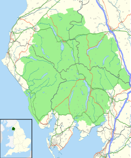
The Lake District, also known as the Lakes or Lakeland, is a mountainous region in North West England. A popular holiday destination, it is famous for its lakes, forests and mountains, and its associations with William Wordsworth and other Lake Poets and also with Beatrix Potter and John Ruskin. The National Park was established in 1951 and covers an area of 2,362 square kilometres. It was designated a UNESCO World Heritage Site in 2017.

Kirkby Lonsdale a town in Cumbria, England

Kirkby Lonsdale is a small town and civil parish in the South Lakeland district of Cumbria, England, on the River Lune. Historically in Westmorland, it is situated 13 miles (21 km) south east of Kendal along the A65. The parish had a population of 1,771, recorded in the 2001 census, increasing to 1,843 at the 2011 Census.

Ennerdale Water reservoir in the United Kingdom

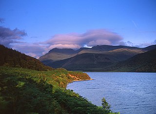
Ennerdale Water is the most westerly lake in the Lake District National Park in Cumbria, England. It is a glacial lake, with a maximum depth of 150 feet, and is ½ mile to a mile wide and 2½ miles long.

Birkrigg stone circle

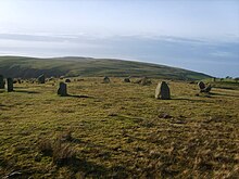
The Birkrigg stone circle is a Bronze Age stone circle on Birkrigg Common, two miles south of Ulverston in the English county of Cumbria. It dates to between 1700 and 1400 BC.

River Ehen river in Cumbria, United Kingdom

The River Ehen is a river in Cumbria, England.

River Liza river in the Lake District, United Kingdom

The River Liza flows through Ennerdale, a glacial valley in Cumbria, England. The river is allowed to flow freely as part of a rewilding project.

Ennerdale, Cumbria valley in Cumbria, United Kingdom

Ennerdale is a valley in Cumbria, England. Ennerdale Water, fed by the River Liza, is the most westerly lake in the Lake District National Park.

Grike (Lake District) mountain in United Kingdom

Grike is a hill in the west of the English Lake District, near Ennerdale Water. It is part of the Lank Rigg group, the most westerly Wainwright as the fells diminish toward the coastal plain. It can be climbed from Kinniside or Ennerdale Bridge.

Casterton, Cumbria village and civil parish in Cumbria, England

Casterton is a small village and civil parish close to Kirkby Lonsdale on the River Lune in the south east corner of Cumbria, England. The population of the civil parish taken at the 2011 census was 425.

Caw Fell mountain in United Kingdom

Caw Fell is a fell in the English Lake District, standing between Haycock the Lank Rigg group. It occupies a wide upland area with Ennerdale to the north and Blengdale to the south. Caw Fell is distant from any point of access by Lakeland standards, but can be climbed from Blengdale or Bowness Knott car-parks.

Lank Rigg mountain in United Kingdom

Lank Rigg is a fell in the English Lake District. It stands to the south of Ennerdale in the Western Fells. A sprawling hill with gentle grassy slopes it can be climbed from various points on the Coldfell road. It carries various remains from ancient habitation.

Flat Fell mountain in United Kingdom

Flat Fell is a hill located on the edge of the English Lake District, standing at 272m. It is included in Alfred Wainwright's Outlying Fells of Lakeland book, sharing a chapter with Dent. Wainwright's clockwise route to the two summits starts at Wath Brow.

Burnmoor stone circles

The Burnmoor Stone Circles are a group of five different approximately 4000-year-old stone circles in Cumbria. They are around 1 mile north of the village of Boot. The site which covers roughly a square mile is looked after by the National Trust. The largest circle is known as Brat's Hill and there are two nearby pairs of circles known as White Moss and Low Longrigg.

Pooley Bridge (structure) bridge in Cumbria, England

Pooley Bridge was an historic stone road bridge that crossed the River Eamont in the village of Pooley Bridge near the northern end of Ullswater. It connected two civil parishes, Barton and Dacre, and was grade II listed in January 1991.

Ennerdale and Kinniside is a civil parish in the Borough of Copeland, Cumbria, England. It contains four listed buildings that are recorded in the National Heritage List for England. All the listed buildings are designated at Grade II, the lowest of the three grades, which is applied to "buildings of national importance and special interest". The parish is in the Lake District National Park, and contains the settlements of Ennerdale Bridge and Croasdle, but most of it consists of countryside, moorland and mountain. The listed buildings comprise a house, a farmhouse and stable, a packhorse bridge, and a telephone kiosk.

Ennerdale and Kinniside civil parish in Cumbria, England

Ennerdale and Kinniside is a civil parish in Copeland, Cumbria, England. At the 2011 census it had a population of 220.

Pillar and Ennerdale Fells is a Site of Special Scientific Interest (SSSI) in Ennerdale, Cumbria, England. Protected for its biological interest, the site is named after Pillar, which at 892 metres (2,927 ft) is the eighth-highest mountain in the Lake District, and other fells in the same range. The area is 425.25 ha.

References

  1. "Kinniside Stone Circle". Visit Cumbria. Retrieved 17 August 2015.
  2. 1 2 3 4 Historic England. "Monument No. 8812". PastScape. Retrieved 17 August 2015.

Commons-logo.svg Media related to Kinniside Stone Circle at Wikimedia Commons