
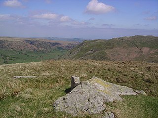
Shipman Knotts is a fell in the English Lake District in Cumbria, England. It reaches a height of 587 metres (1,926 ft) and is situated in one of the quieter areas of the national park, 2 kilometres (1.2 mi) north-east of Kentmere village. Although not one of the best-known Lake District fells and strictly speaking it is just the southern shoulder of Kentmere Pike it earned a separate chapter in Alfred Wainwright’s Pictorial Guide to the Lakeland Fells due to “Its characteristic roughness…rocky outcrops are everywhere on its steep slopes”.
Walna Scar is a hill in the English Lake District, lying just south of a pass of the same name in the Coniston Hills. Its summit at 2,035 feet (620 m) is only slightly higher than the pass.

The Outlying Fells of Lakeland is a book written by Alfred Wainwright, dealing with hills in and around the Lake District of England. It differs from Wainwright's Pictorial Guides in that each of its 56 chapters describes a walk, sometimes taking in several summits, rather than a single fell. This has caused some confusion on the part of authors attempting to prepare a definitive list of peaks. The Outlying Fells do not form part of the 214 hills generally accepted as making up the Wainwrights, but they are included in Category 2B of the Hill Walkers' Register maintained by the Long Distance Walkers Association.
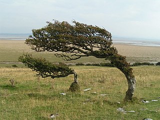
Humphrey Head is a limestone outcrop situated south of the village of Allithwaite in Cumbria, England. It is whale-back-shaped and accessible for walkers, giving views over Morecambe Bay to Lancaster, Morecambe, Heysham and over the Leven estuary to Ulverston. There is an Ordnance Survey trig point at the top.
Burney is a hill in Cumbria, England, to the north of the A5092 road between Greenodd and Broughton-in-Furness. It is the subject of a chapter of Wainwright's book The Outlying Fells of Lakeland. It reaches 979 feet (298 m) and has a trig point at the summit. It is also known as Great Burney, and a slight rise on the north ridge is named Little Burney.

School Knott is a hill in the Lake District, England, to the east of Windermere town, Cumbria. It is the subject of a chapter of Wainwright's book The Outlying Fells of Lakeland. His recommended route starts at Windermere railway station and includes Grandsire at 818 feet (249 m) and a nameless summit at 806 feet (246 m). The summit is at 760 feet (230 m) and offers a view of four sections of Windermere, the lake. It has a rocky outcrop but no trig point and, as reported by Wainwright, no cairn. Schoolknott Tarn is to the south-east of the summit.

The Bannisdale Horseshoe is an upland area near the eastern boundary of the Lake District National Park, surrounding the valley of Bannisdale Beck, a tributary of the River Mint. It is described in the final chapter of Wainwright's book The Outlying Fells of Lakeland. It describes

Scout Scar, also called Underbarrow Scar, is a hill in the English Lake District, west of Kendal, Cumbria and above the village of Underbarrow. It reaches 771 feet (235 m). Scout Scar is the subject of a chapter of Wainwright's book The Outlying Fells of Lakeland, but the summit he describes is a lower summit at 764 feet (233 m), 270m south of the highest point. Wainwright's anticlockwise recommended route also includes Cunswick Scar at 679 feet (207 m). The higher summit of Scout Scar has a topographic prominence of 109m and is thus classified as a HuMP, a hill with a prominence of at least 100m.

The Wasdale Horseshoe is a group of hills on the eastern fringe of the English Lake District, to the west of the A6, south of Shap, Cumbria. They surround the valley of Wasdale Beck, a tributary of Birk Beck and ultimately of the River Lune. The horseshoe is the subject of a chapter of Wainwright's book The Outlying Fells of Lakeland. This Wasdale should not be confused with the better known Wasdale, containing Wast Water, on the west of the Lake District.

The Naddle Horseshoe is a group of summits in the English Lake District, south of Mardale valley, Cumbria. It is the subject of a chapter of Wainwright's book The Outlying Fells of Lakeland.
Blawith Knott is a hill in the south of the English Lake District, near Woodland, Cumbria. It is the subject of a chapter of Wainwright's book The Outlying Fells of Lakeland. It reaches 806 feet (246 m) and Wainwright's clockwise route from the fell road to the south-west also includes Tottlebank Height at 775 feet (236 m). He describes Blawith Knott as "a magnificent viewpoint", with both a panorama of Lake District fells to the north and, to the east to south, views which, on a clear day, include the Howgill Fells, Whernside and Ingleborough.
The Crookdale Horseshoe is a group of hills on the eastern edge of the English Lake District, in Cumbria, west of the A6 road. They are the subject of a chapter of Wainwright's book The Outlying Fells of Lakeland. Wainwright describes an anticlockwise walk starting along the valley of Crookdale Beck to reach Lord's Seat at 1,719 feet (524 m), and returning over Robin Hood at 1,613 feet (492 m) and High House Bank at 1,627 feet (496 m). As he points out, the ridge forming the northern part of the "horseshoe" is described in his Wasdale Horseshoe chapter.

Brant Fell is a hill in the English Lake District, near Bowness-on-Windermere, Cumbria. It is the subject of a chapter of Wainwright's book The Outlying Fells of Lakeland. It reaches 629 feet (192 m). Wainwright's route leaves Bowness along the path of the Dales Way, makes an anticlockwise loop over the viewpoint of Post Knott to the summit, and either returns along the Dales Way or follows a woodland path to Helm Road from where another viewpoint, Biskey Howe, is only a slight detour before continuing down Helm Road to Bowness. He commends its "fine prospect of Windermere".

Heughscar Hill is a hill in the east of the English Lake District, east of Ullswater and north of High Street, Cumbria. It is the subject of a chapter of Wainwright's book The Outlying Fells of Lakeland. It reaches 1,231 feet (375 m) and Wainwright's route is an anticlockwise circuit starting at Askham. He describes it as "A gem for aged fellwalkers"'.
Howes is a subsidiary summit of Branstree in the English Lake District, south east of Selside Pike in Cumbria. It is the subject of a chapter of Wainwright's book The Outlying Fells of Lakeland. Wainwright's route starts at Swindale Head and follows Swindale Beck, then passes over Nabs Moor at 1,613 feet (492 m) to reach the summit of Howes at 1,930 feet (590 m), dropping down to Mosedale Beck to complete an anticlockwise circuit. Wainwright states that Howes is "merely a subsidiary and undistinguished summit on the broad eastern flank of Barnstree. There is nothing exciting about it ..." but commends the sight of Mosedale quarry and the waterfalls of Swindale Head which he describes as "extremely fine, up to Lodore standard".

Hugill Fell is a hill in the English Lake District, near Staveley, Cumbria, on the western side of the Kentmere valley. It is the subject of a chapter of Wainwright's book The Outlying Fells of Lakeland. It reaches 840 feet (260 m) and Wainwright's walk is an ascent from Staveley and return on the same route. There is a cairn on the summit.

Green Quarter Fell is an upland area in the east of the English Lake District, near Kentmere village, Cumbria. It is the subject of a chapter of Wainwright's book The Outlying Fells of Lakeland. Wainwright's walk is an anticlockwise circuit from Kentmere, reaching the summit of Hollow Moor at 1,394 feet (425 m) and a nameless summit at 1,370 feet (420 m) and making a detour to admire the tarn of Skeggles Water. He says that the walk offers: "... a perfectly-balanced and lovely view of upper Kentmere ... that cries aloud for a camera."

Knipescar Common, or Knipe Scar, is an upland area in the east of the English Lake District, above the River Lowther, near Bampton, Cumbria. It is the subject of a chapter of Wainwright's book The Outlying Fells of Lakeland. The summit is "indefinite" but reaches 1,118 feet (341 m) and there are limestone outcrops and an ancient enclosure. Wainwright commends the views which include Blencathra to the north and "a continuous skyline of the higher Pennines."
Woodland Fell is an upland area in the south of the English Lake District, south of Torver, Cumbria. It is the subject of a chapter of Wainwright's book The Outlying Fells of Lakeland. Wainwright's route is a clockwise circuit from the hamlet of Woodland, and includes the summits of Yew Bank at 678 feet (207 m) and Wool Knott at 730 feet (220 m), with Beacon Tarn between them. He describes the walk as: "a connoisseur's piece, every step an uninhibited joy, every corner a delight."

Latterbarrow is a hill in the English Lake District, east of Hawkshead, Cumbria. It is the subject of a chapter of Wainwright's book The Outlying Fells of Lakeland. It reaches 803 feet (245 m) and is surmounted by a monument, but Wainwright, unusually, makes no comment on the monument's age or purpose, merely mentioning this "... elegant obelisk being prominently in view from Hawkshead and the Ambleside district." He recommends an anticlockwise circuit from Colthouse, near Hawkshead, and describes it as "a circular walk needing little effort yet yielding much delight".
