A590 road

Last updated

UK road A590.svg
A590
Route information
Length34 mi (55 km)
Major junctions
North East end M6 Junction 36 nr. Kendal
54°14′12″N2°43′04″W / 54.2368°N 2.7179°W / 54.2368; -2.7179 (A590 road (northeastern end))
Major intersectionsUK road A65.svg A65
UK-Motorway-M6.svg M6
UK road A591.svg A591
UK road A6.svg A6
UK road A5074.svg A5074
UK road A592.svg A592
UK road A5092.svg A5092
UK road A5087.svg A5087
UK road A595.svg A595
South West end Vickerstown, Walney Island, Barrow-in-Furness
54°05′51″N3°15′28″W / 54.0976°N 3.2578°W / 54.0976; -3.2578 (A590 road (southwestern end))
Location
Country United Kingdom
Primary
destinations
Barrow-in-Furness
Road network

The A590 is a trunk road in southern Cumbria, in the north-west of England. It runs north-east to south-west from M6 junction 36, through the towns of Ulverston and Barrow-in-Furness to terminate at Biggar Bank on Walney Island. [1] The road is a mixture of dual carriageway and single carriageway, with the section east of Low Newton, Cumbria to the M6 being mainly dual. Further dual sections are south of Newby Bridge, south of Greenodd and south of Ulverston. The road is the main route for tourists entering the southern Lake District. [2] It has often humorously been described as "the longest cul-de-sac in the world". [3]

Contents

Route

M6 to Ulverston

A590 by-pass at High and Low Newton A590(T) - geograph.org.uk - 872779.jpg
A590 by-pass at High and Low Newton

From east to west, the A590 originally terminated at the A6 road at Levens Bridge. [1] Its route followed a number of country roads via a series of Turn Off To Stay On (TOTSO)'s, passing through a number of villages including Lindale, High and Low Newton, Newby Bridge and Greenodd into the larger town of Ulverston. This road formed a large part of the southern boundary of the Lake District National Park upon its formation in 1951.

This stretch of road has now undergone a series of improvements and route alignments. In the mid-1970s, the A591 'Kendal link road' was built between Junction 36 of the M6 and Kendal [4] with an extension of the A590 also being constructed to join this as part of the wider Lancashire expressways plans. [5] This improvement to the A590 also included a realignment and dualling of the road to the west as far as High Newton, by-passing Lindale. In the mid-1990s the A590 was extended eastward through a re-numbering of the A591 between Sizergh and the M6, providing a single road between Barrow-in-Furness and the M6. [1]

West of the Lindale bypass is the road's most recent improvement, a 2.4-mile (3.8-kilometre) long stretch of dual carriageway built to bypass High and Low Newton at a cost of £35.3 million. [6] This new stretch of road was constructed to a high environmental standard and achieved a CEEQUAL Award following its opening in Spring 2008. [7] It connects to the original route to the east of Newby Bridge. The A590 reaches its most northern point at the foot of Windermere, before following the route of the River Leven to its estuary at Greenodd. [1] Both the villages of Backbarrow and Greenodd have now been by-passed, though parts of this route remain narrow and winding. [1] West of Greenodd the road switches between sections of single and dual carriageway.

Ulverston-Walney Island

A590 crossing Walney Bridge in Barrow-in-Furness Walney Bridge - geograph.org.uk - 1434582.jpg
A590 crossing Walney Bridge in Barrow-in-Furness

The A590 passes through Ulverston, [1] avoiding its most central streets, along an inner relief road. West of Ulverston the road is entirely single carriageway and is mainly used for commuting between Ulverston, Barrow-in-Furness and the small towns in-between the two. [1] West of Dalton-in-Furness, the A590 follows an entirely different route to that it did prior to the early 1990s when Dalton was bypassed. Previously, the road had gone through Dalton and entered Barrow along the wide Victorian Abbey Road, before passing through Barrow's shipyard onto Barrow Island. [1]

Since 1992, the road has followed a modern bypass close to the South Lakes Safari Zoo and enters Barrow via its north-western industrial area, parallel to Walney Island passing the site of Barrow's former iron and steelworks. A one way system opened in April 2008 now applies to the road as it passes closest to the centre of Barrow, with westbound traffic heading towards the town centre at Craven Park roundabout and eastbound traffic continuing through the industrial land alongside Walney Channel. [8] The road continues westward over the Jubilee Bridge onto Walney Island and terminates at the Irish Sea

Related Research Articles

<span class="mw-page-title-main">A6 road (England)</span> North-south road in England

The A6 is one of the main north–south roads in England. It runs from Luton in Bedfordshire to Carlisle in Cumbria, although it formerly started at a junction with the A1 at Barnet. It is the fourth longest numbered road in Britain; only the A1, A38 and A30 are longer.

<span class="mw-page-title-main">Barrow-in-Furness</span> Town in Cumbria, England

Barrow-in-Furness is a port town in Cumbria, England. Historically in Lancashire, it was incorporated as a municipal borough in 1867 and merged with Dalton-in-Furness Urban District in 1974 to form the Borough of Barrow-in-Furness. In 2023, the borough merged with Eden and South Lakeland districts to form a new unitary authority: Westmorland and Furness. At the tip of the Furness peninsula, close to the Lake District, it is bordered by Morecambe Bay, the Duddon Estuary and the Irish Sea. In 2011, Barrow's population was 56,745, making it the second largest urban area in Cumbria after Carlisle, and the largest in the Westmorland and Furness unitary authority.

<span class="mw-page-title-main">A595 road</span> Road in Cumbria, England

The A595 is a primary route in Cumbria, in Northern England that starts in Carlisle, passes through Whitehaven and goes close to Workington, Cockermouth and Wigton. It passes Sellafield and Ravenglass before ending at the Dalton-in-Furness by-pass, in southern Cumbria, where it joins the A590 trunk road. The road is mostly single carriageway, apart from in central Carlisle, where it passes the castle as a busy dual carriageway road named Castle Way, and prior to that as Bridge Street and Church Street, where it passes close to the McVitie's or Carr's biscuit factory. The Lillyhall bypass is also dual carriageway.

<span class="mw-page-title-main">A59 road</span> Road in Northern England

The A59 is a major road in England which is around 109 miles (175 km) long and runs from Wallasey, Merseyside to York, North Yorkshire. The alignment formed part of the Trunk Roads Act 1936, being then designated as the A59. It is a key route connecting Merseyside at the M53 motorway to Yorkshire, passing through three counties and connecting to various major motorways. The road is a combination of historical routes combined with contemporary roads and a mixture of dual and single carriageway. Some sections of the A59 in Yorkshire closely follow the routes of Roman roads, some dating back to the Middle Ages as salt roads, whilst much of the A59 in Merseyside follows Victorian routes which are largely unchanged to the present day.

<span class="mw-page-title-main">Furness Railway</span> English railway company

The Furness Railway (Furness) was a railway company operating in the Furness area of Lancashire in North West England.

<span class="mw-page-title-main">Furness</span>

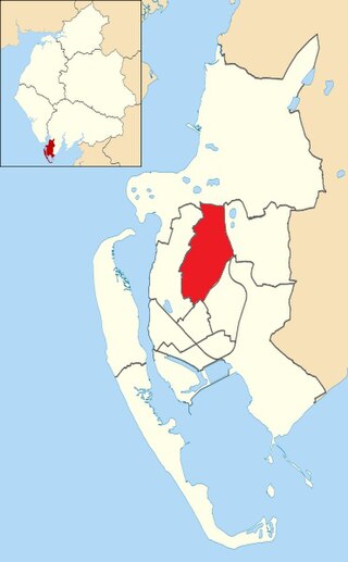
Furness is a peninsula and region of Cumbria in northwestern England. Together with the Cartmel Peninsula it forms North Lonsdale, historically an exclave of Lancashire. On 1 April 2023 it became part of the new unitary authority of Westmorland and Furness.

<span class="mw-page-title-main">Greenodd</span> Human settlement in England

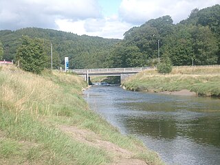
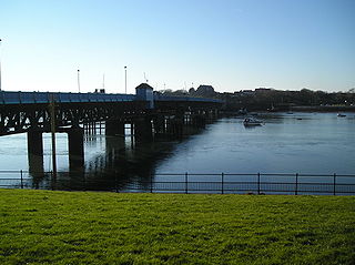
Greenodd is a village in the Furness area of the county of Cumbria, England, but within the historical county of Lancashire. For local government purposes the village is also within the area of South Lakeland District. It is located 3 miles (5 km) north-east of Ulverston at the junction of the A590 trunk road and the A5092 trunk road. The village is just outside the boundary of the Lake District National Park at 54°14′N3°3′W. Greenodd is within the Crake Valley area of South Lakeland District. The 2001 UK census gives a population of 1823 for the Crake Valley. Greenodd and adjacent Penny Bridge are the main districts in the Crake Valley. The River Crake flows into the estuary of the River Leven at Greenodd.

<span class="mw-page-title-main">Dalton-in-Furness</span> Town in England

Dalton-in-Furness is a town and former civil parish, now in the parish of Dalton Town with Newton, in the Westmorland and Furness district, in the ceremonial county of Cumbria, England. In 2011 it had a population of 7,827. It is located 4.4 miles (7 km) north east of Barrow-in-Furness.

<span class="mw-page-title-main">Walney Island</span> Island in the United Kingdom

Walney Island, also known as the Isle of Walney, is an island off the west coast of England, at the western end of Morecambe Bay in the Irish Sea. It is part of Barrow-in-Furness, separated from the mainland by Walney Channel, which is spanned by the Jubilee Bridge. Walney is the largest island of the Furness Islands group, both in population and size, as well as the largest English island in the Irish Sea. Its population at the 2011 UK Census was 10,651, distributed evenly across the island's two Wards of Walney North and Walney South.

<span class="mw-page-title-main">Newby Bridge</span> Human settlement in England

Newby Bridge is a small hamlet in the Lake District, Cumbria, England. Historically in Lancashire, it is located several miles west of Grange-over-Sands and is on the River Leven, close to the southern end of Windermere.

<span class="mw-page-title-main">Ulverston railway station</span> Railway station in Cumbria, England

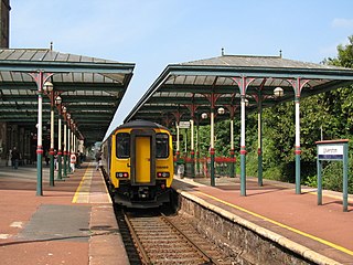
Ulverston is a railway station on the Furness Line, which runs between Barrow-in-Furness and Lancaster. The station, situated 9+12 miles (15 km) north-east of Barrow-in-Furness, serves the market town of Ulverston in Cumbria. It is owned by Network Rail and managed by Northern Trains.

<span class="mw-page-title-main">Hawcoat</span> Human settlement in England

Hawcoat is an area and electoral ward of Barrow-in-Furness, Cumbria, England. Historically part of Lancashire, it is one of Barrow's most northerly wards and is bordered by Roose, Newbarns, Parkside, Ormsgill and the town of Dalton-in-Furness to the north.

<span class="mw-page-title-main">Askam and Ireleth</span> Civil parish in England

Askam and Ireleth is a civil parish close to Barrow-in-Furness in Westmorland and Furness, Cumbria, England. Historically part of Lancashire, it originally consisted of two separate coastal villages with different origins and histories which, in recent times, have merged to become one continuous settlement. In the 2001 census the parish had a population of 3,632, reducing at the 2011 census to 3,462.

<span class="mw-page-title-main">Low Newton, Cumbria</span> Human settlement in England

Low Newton is a hamlet in the South Lakeland District, in the county of Cumbria, England and in the Lake District also commonly known as The Lakes. It was on the A590 road until along with its neighbour High Newton a bypass was built, opening on Tuesday 8 April 2008.

<span class="mw-page-title-main">Staveley-in-Cartmel</span> Human settlement in England

Staveley-in-Cartmel is a small village and civil parish in South Lakeland district, Cumbria, England. It lies east of Newby Bridge, near the south end of Windermere, 9 miles (14 km) northeast of Ulverston. It is sometimes known as Staveley-in-Furness. Both names distinguish it from another Staveley in Cumbria. In the 2001 census the parish had a population of 428, decreasing at the 2011 census to 405.

<span class="mw-page-title-main">Bay Cycle Way</span> Cycle route around Morecambe Bay in NW England

The Bay Cycle Way is an 80-mile (130 km) cycling route around Morecambe Bay in Lancashire and Cumbria in north west England. Most of it forms National Cycle Route 700, while other sections are waymarked as NCN 6, NCN 69 and NCN 70.

References

  1. 1 2 3 4 5 6 7 8 A590: M6 J36 (Crooklands) – Walney Island SABRE; retrieved 07-05-08
  2. Destinations in Lake District Peninsulas Archived 9 May 2008 at the Wayback Machine Lake-district-peninsulas.co.uk; retrieved 07-05-08
  3. Barrow boys are brought back to earth guardian.co.uk; retrieved 05-01-08
  4. M6 Junction 36 Route 6; retrieved 7 May 2008
  5. ROADS IN LANCASHIRE: Historic Overview and Maps Lancashire Motorways and Roads Site; retrieved 7 May 2008
  6. Welcome to the A590 Now Campaign – Bypass realised – traffic flowing! Archived 15 May 2008 at the Wayback Machine Retrieved 7 May 2008
  7. CEEQUAL Award – A590 High and Low Newton Bypass Archived 7 January 2009 at the Wayback Machine
  8. How many people will die? [ permanent dead link ] North West Evening Mail 29 April 2008; retrieved 7 May 2008
Map all coordinates using: OpenStreetMap

54°14′56″N3°00′12″W / 54.2490°N 3.0032°W / 54.2490; -3.0032 (A590 road)