
Barrow-in-Furness is a port town and civil parish in the Westmorland and Furness district of Cumbria, England. Historically in Lancashire, it was incorporated as a municipal borough in 1867 and merged with Dalton-in-Furness Urban District in 1974 to form the Borough of Barrow-in-Furness. The borough was merged into the new Westmorland and Furness district in 2023. At the tip of the Furness peninsula, close to the Lake District, it is bordered by Morecambe Bay, the Duddon Estuary and the Irish Sea. In 2021, Barrow's population was 55,489, making it the second largest urban area in Cumbria after Carlisle, and the largest in the Westmorland and Furness unitary authority.

Barrow Island is an area and former electoral ward of Westmorland and Furness, Cumbria, England. Originally separate from the British mainland, land reclamation in the 1860s saw the northern fringes of the island connected to Central Barrow. Barrow Island is also bound to the south and east by the town's dock system and to the west by Walney Channel. The Ward population taken at the 2011 census was 2,616.
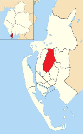
Hawcoat is an area and former electoral ward of Barrow-in-Furness, Cumbria, England. Historically part of Lancashire, it is one of Barrow's most northerly wards and is bordered by Roose, Newbarns, Parkside, Ormsgill and the town of Dalton-in-Furness to the north.
The Barrow Blitz is the name given to the Luftwaffe bombings of Barrow-in-Furness, United Kingdom during World War II. They took place primarily during April and May 1941, although the earliest Luftwaffe bombing occurred in September 1940. VSEL shipyard was the main target for bombing alongside Barrow's steelworks, which were formerly the largest in the world.
Hindpool is an area and electoral ward of Barrow-in-Furness, Cumbria, England. It is bordered by Barrow Island, Central Barrow, Ormsgill, Parkside and the Walney Channel, the local population stood at 5,851 in 2011. The ward covers the entire western half of the town centre and includes Barrow's main shopping district. Other local landmarks include the Furness College Channelside campus, the Dock Museum and the Main Public Library. Hindpool is also home to two stadia - Barrow Raiders' Craven Park and Barrow A.F.C.'s Holker Street.

Newbarns is an area and electoral ward of Barrow-in-Furness, Cumbria, England. It is bordered by Hawcoat, Parkside, Risedale and Roose, the local population stood at 5,515 in 2001, decreasing to 5,487 at the 2011 Census.
There are 274 listed buildings in the former Borough of Barrow-in-Furness, with about 70% in Barrow-in-Furness itself. The 2015 Heritage Index formed by the Royal Society of Arts and the Heritage Lottery Fund placed the Borough as seventh highest of 325 English districts with an especially high score relating to industrial heritage assets. The Barrow Island conservation area contains dozens of historic shipyard buildings and tenements, while numerous listed buildings can be found lining Abbey Road and Duke Street, which were designed as the principal north to south and east to west thoroughfares of the Victorian planned town. Despite many buildings and structures dating from this era, an abundance of listed buildings exist throughout the Borough that pre-date Barrow, in villages that were consumed by the rapidly expanding town. One notable example being Newbarns village which retains its original 18th century street layout. Significant clusters of listed buildings can be found around the ruins of the 12th-century Furness Abbey and Market Street, the Medieval centre of Dalton-in-Furness. The oldest listed building in Barrow is Furness Abbey, dated 1127 and the newest is the John Whinnerah Institute, completed in 1934.
Parkside is an area and former electoral ward of Barrow-in-Furness, Cumbria, England. It is bordered by Hindpool, Ormsgill, Hawcoat, Newbarns and Risedale and had a population of 5,742 in 2001, reducing to 5,584 at the 2011 Census. It is one of the town's most centralised wards and contains Barrow's main park, as well as the newly established Furness Academy.

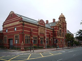
Barrow-in-Furness Main Public Library is a Grade II listed Beaux-Arts style building located at Ramsden Square, Barrow-in-Furness, England. Operated since 2023 by Westmorland and Furness Council, it is the largest library in the town and the present structure, designed by J A Charles was originally built as a Carnegie library with support from the Carnegie Foundation.
Duke Street is a road running through the town centre and Hindpool area of Barrow-in-Furness, England. Stretching almost one mile from east to west it connects two major A roads as well as intersecting Abbey Road roughly midway. Designed by Sir James Ramsden as the centrepiece of the 19th century planned town of Barrow, Duke Street is home to three squares alongside many listed buildings including Barrow Town Hall and the Main Public Library. The Forum performing arts centre and Craven Park Stadium are also located on Duke Street.
The Nan Tait Centre is a Grade II listed building located at Abbey Road in the Hindpool area of Barrow-in-Furness, Cumbria, England.

The John Whinnerah Institute is a Grade II listed Art Deco building and former educational establishment located on Abbey Road in Barrow-in-Furness, England. Having been constructed between 1937 and 1938 on the site of the demolished Jute Works it is the newest listed structure in the town, despite this it was drastically altered in 2004 when the entire interior was demolished to accommodate new retail units leaving only the Abbey Road and Hindpool Road facades.

The National Westminster Bank building in Barrow-in-Furness, Cumbria, England is located at the intersection of Abbey Road and Duke Street. It was designed by Paley and Austin architects and built between 1873–74 and has been designated a Grade II listed building by English Heritage. Built for the Lancaster branch of the National Westminster Bank it was a major component of the Ramsden Square scheme, one of the planned town's two main squares and focal points. It is one of three former 'Nat West' properties with listed building status in the Borough and currently houses a carpet shop in the lower floors.

The Barrow Jute Works was a jute and flax mill located in Barrow-in-Furness, Lancashire, England during the late 19th and early 20th centuries. The mill was built for the Barrow and Calcutta Jute Company which was founded by James Ramsden in 1870 in an attempt to diversify Barrow's economy which was heavily focused on iron and steel production. The Jute Works itself was designed by architects Paley and Austin and occupied over 12-acres with a 580 feet (177 m) facade on Hindpool Road and 360 feet (110 m) along Abbey Road. The mill was served by its own railway station on a branch of the Furness Railway which connected it to the town's docks, steelworks and cornmill.

Furness Abbey railway station was located in the Barrow-in-Furness area of the Furness Peninsula, England. It opened in 1846, closed in 1950 and was subsequently demolished.

The Custom House in Barrow-in-Furness, Cumbria, England is a former government building, having housed the customs offices for trade handled at the Ports of Barrow and Lancaster. Initially constructed as a hotel around 1870, it took on its most notable role as a custom house in 1880, regulating custom from the Port of Lancaster.
The following is a timeline of the history of Barrow-in-Furness, England, United Kingdom.

Ramsden Square is a square located at the intersection of Abbey Road and Duke Street in Barrow-in-Furness, Cumbria, England. It marks the boundary of the Central and Hindpool wards and now acts as a major roundabout. Ramsden Square was first laid out in the 1840s to act as a focal point of Sir James Ramsden's master plan for the new town of Barrow, separating its burgeoning industries and commercial core. The centerpiece of the square is a statue of Ramsden himself while it is framed by a number of historic buildings including Barrow Central Library, the National Westminster Bank Building and formerly the Barrow Jute Works.
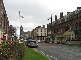
Schneider Square is a square located at the intersection of Duke Street, Dalton Road, Michaelson Road, Burlington Street and Fisher's Yard in Barrow-in-Furness, Cumbria, England. Schneider Square has changed little since its construction in the mid-19th century and now lies within a conservation area. Named after Henry Schneider who played a major role in the development of Barrow, there is a statue commemorating the industrialist in the centre of the square. Located on, or immediately adjacent to Schneider Square are Barrow Town Hall, Craven House, former Barrow Higher Grade School, Hotel Majestic, Burlington House and Duke Street Surgery.


