
Barrow Island is an area and former electoral ward of Westmorland and Furness, Cumbria, England. Originally separate from the British mainland, land reclamation in the 1860s saw the northern fringes of the island connected to Central Barrow. Barrow Island is also bound to the south and east by the town's dock system and to the west by Walney Channel. The Ward population taken at the 2011 census was 2,616.
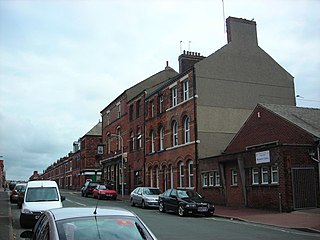
Hindpool is an area and electoral ward of Barrow-in-Furness, Cumbria, England. It is bordered by Barrow Island, Central Barrow, Ormsgill, Parkside and the Walney Channel, the local population stood at 5,851 in 2011. The ward covers the entire western half of the town centre and includes Barrow's main shopping district. Other local landmarks include the Furness College Channelside campus, the Dock Museum and the Main Public Library. Hindpool is also home to two stadia - Barrow Raiders' Craven Park and Barrow A.F.C.'s Holker Street.
Henry William Schneider was a British industrialist, and politician, who played a leading role in the development of the new town of Barrow-in-Furness.

Abbey Road is the principal north to south arterial road through Barrow-in-Furness, Cumbria, England.
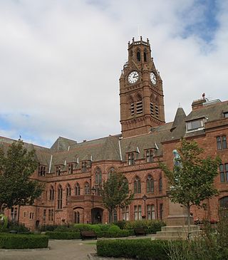
Barrow-in-Furness Town Hall is a Gothic Revival style municipal building in Barrow-in-Furness, Cumbria, England. The building, which served as the headquarters of the former Barrow Borough Council, and now one of the bases of Westmorland and Furness Council, lies within a Conservation Area with Grade II* listed status.

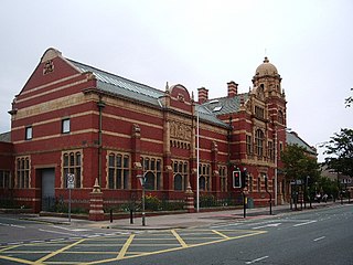
Barrow-in-Furness Main Public Library is a Grade II listed Beaux-Arts style building located at Ramsden Square, Barrow-in-Furness, England. Operated since 2023 by Westmorland and Furness Council, it is the largest library in the town and the present structure, designed by J A Charles was originally built as a Carnegie library with support from the Carnegie Foundation.

St. George's Church is in St George's Square, Barrow-in-Furness, Cumbria, England. It is the oldest active Anglican parish church in the town. The church is in the deanery of Barrow, the archdeaconry of Westmorland and Furness, and the diocese of Carlisle. Its benefice is united with those of St Aidan, Newbarns, St Luke, Risedale, and St Perran, Roose, to form the South Barrow Team Ministry. The church is recorded in the National Heritage List for England as a designated Grade II listed building. It stands at the southeast extremity of the town.
The Nan Tait Centre is a Grade II listed building located at Abbey Road in the Hindpool area of Barrow-in-Furness, Cumbria, England.

The Barrow Hematite Steel Company Limited was a major iron and steel producer based in Barrow-in-Furness, Lancashire, England, between 1859 and 1963. At the turn of the 20th century and the Technological Revolution it operated the largest steel mill in the world.

The National Westminster Bank building in Barrow-in-Furness, Cumbria, England is located at the intersection of Abbey Road and Duke Street. It was designed by Paley and Austin architects and built between 1873–74 and has been designated a Grade II listed building by English Heritage. Built for the Lancaster branch of the National Westminster Bank it was a major component of the Ramsden Square scheme, one of the planned town's two main squares and focal points. It is one of three former 'Nat West' properties with listed building status in the Borough and currently houses a carpet shop in the lower floors.

Abbot's Wood was a large country house and estate located to the north-northeast of Barrow-in-Furness, Cumbria, England. It was sited on elevated ground to the northeast of Furness Abbey. The house was surrounded by extensive grounds with footpaths providing fine views.

Furness Abbey railway station was located in the Barrow-in-Furness area of the Furness Peninsula, England. It opened in 1846, closed in 1950 and was subsequently demolished.

Ramsden Hall located at 48 Abbey Road in Barrow-in-Furness, Cumbria, England is a Grade II listed former public bath house. Funded by industrialist and local mayor Sir James Ramsden it was constructed in 1872 and was relatively small in comparison to other public baths in Barrow. Despite no longer serving its original purpose Ramsden Hall stands as the only remaining example of a 19th-century public bath in the town. For a period of its history, the building served as an annexe of the adjacent Technical School although at present it is occupied by offices of the Citizens Advice Bureau.
St. George's Square, in Barrow-in-Furness, Cumbria, England is a public space that acted as the centre of the town during the late 19th century. The square now lies in the southernmost fringes of the Central ward close to the Port of Barrow.
The following is a timeline of the history of Barrow-in-Furness, England, United Kingdom.
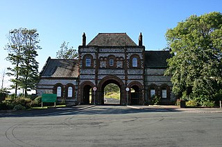
Thorncliffe Cemetery and Crematorium is a 66-acre graveyard located on Devonshire Road in the Ormsgill ward of Barrow-in-Furness, Cumbria, England.

Ramsden Square is a square located at the intersection of Abbey Road and Duke Street in Barrow-in-Furness, Cumbria, England. It marks the boundary of the Central and Hindpool wards and now acts as a major roundabout. Ramsden Square was first laid out in the 1840s to act as a focal point of Sir James Ramsden's master plan for the new town of Barrow, separating its burgeoning industries and commercial core. The centerpiece of the square is a statue of Ramsden himself while it is framed by a number of historic buildings including Barrow Central Library, the National Westminster Bank Building and formerly the Barrow Jute Works.
Schneider Square is a square located at the intersection of Duke Street, Dalton Road, Michaelson Road, Burlington Street and Fisher's Yard in Barrow-in-Furness, Cumbria, England. Schneider Square has changed little since its construction in the mid-19th century and now lies within a conservation area. Named after Henry Schneider who played a major role in the development of Barrow, there is a statue commemorating the industrialist in the centre of the square. Located on, or immediately adjacent to Schneider Square are Barrow Town Hall, Craven House, former Barrow Higher Grade School, Hotel Majestic, Burlington House and Duke Street Surgery.
The Scotch Buildings was a large complex of tenement housing located off Duke Street in Barrow-in-Furness, then Lancashire, United Kingdom. The build was commissioned by the Barrow Hematite Steel Company and constructed somewhat hastily by Scottish firm Smith and Caird between 1871 and 1872 to address a chronic housing shortage in the rapidly expanding town. The complex took on a triangular form with a centrally located courtyard. The four storey building was constructed from the iconic Hawcoat sandstone and was bound by Blake Street, Duke Street and Walney Road. Two shops and a working men's club were sited on the three corners of the building. It contained some 260 flats housing over 1,000 residents. The Scotch Buildings were ultimately demolished in 1956, the entire site is now shared by a Travis Perkins outlet and the Former Agrilek Engineering company office, now Saint Mary's Hospice Furniture Warehouse.

Abbey Road Working Men's Club is a partially destroyed Grade II listed building located at Abbey Road close to Ramsden Square in Barrow-in-Furness, Cumbria, England. Design by architect Henry Darbishire it was completed in 1871 and extended in the early 20th century, notable features previously included an ornate hipped roof with multiple oval dormers and an engraving of the Borough Coat of Arms. During the building's lifetime it functioned as a social club and later public house.


