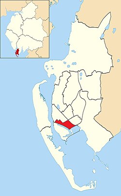
Central Barrow

Last updated

Central Barrow
Central, Barrow location map.jpg
Central Barrow shown within Barrow-in-Furness
Population4,583 (2011)
District
Shire county
Region
Country England
Sovereign state United Kingdom
Post town BARROW-IN-FURNESS
Postcode district LA
Dialling code 01229
Police Cumbria
Fire Cumbria
Ambulance North West
UK Parliament
List of places
UK
England
Cumbria

Central Barrow refers both to the town centre of Barrow-in-Furness, Cumbria, England and to the electoral ward that roughly covers the eastern part of that town centre. In 2001 5,584 (ranking 5th out of 13) lived in the Central ward. [1] The population density was 55.96 per hectare, which was well above the local average of 9.24, and England average, 3.77. [2] The population of Central ward had reduced to 4,583 at the 2011 Census. [3]

Contents

Central Barrow is amongst the 3% most deprived areas in the country and households have an average weekly income around £100 lower than the region's average, [4] however the area being the central business district of the town is also home to many of Barrow's retail outlets, as well as a large amount of offices, restaurants and governmental buildings. Part of the £200 million Waterfront Barrow-in-Furness project is being constructed in the southern part of Central Barrow (including the new Marina Village).

The ward itself will be combined with Barrow Island and Hindpool wards in April 2023 following formation of the new Westmorland and Furness Local Authority and be named 'Old Barrow'.

In a bid to tackle issues related with Central Barrow such as deprivation, unemployment and poor housing quality/choice, Barrow Borough Council is currently preparing the 'Central Barrow Masterplan' which will set out guidelines for the redevelopment of Central Barrow. The plan will also put forward proposals for a bus station/transport interchange to replace the existing shelters outside of the town hall. It is not yet known when the plan will be published or what exactly it will include.

Demographics

Vital statistics [5] Central BarrowBarrow-in-FurnessEngland
Religious individuals75.72%81.61%77.71%
Non-religious individuals15.52%10.79%14.59%
Religion withheld9.08%7.59%7.69%
Individuals in fairly
good to good health
81.20%86.75%90.97%
Individuals in bad health18.80%13.25%9.03%
People aged 16–74 who
are economically active
54.88%60.84%66.87%
People aged 16–74 who
aren't economically active
45.12%39.16%33.13%
People aged 16–74
with no qualifications
41.34%32.82%28.85%

See also

Related Research Articles

<span class="mw-page-title-main">Upminster</span> Town in East London

Upminster is a suburban town in East London, England, within the London Borough of Havering. Located 16.5 miles (26.6 km) east-northeast of Charing Cross, it is one of the locally important district centres identified in the London Plan.

<span class="mw-page-title-main">Elm Park</span> Human settlement in England

Elm Park is a suburban planned community in East London and part of the London Borough of Havering. Located 14.3 miles (23.0 km) east-northeast of Charing Cross, it is identified as a district centre in the London Plan with several streets of shops and a priority for regeneration. Prior to the construction of the extensive Elm Park Garden City development in the 1930s it was a scattered settlement of farms in the south of the parish of Hornchurch. Elm Park has been connected to central London by the electrified District line service since 1935 and the planned development of the area formed part of the interwar private housing boom that was interrupted by World War II. After the war Elm Park expanded with social housing and it has formed part of Greater London since 1965.

<span class="mw-page-title-main">Barrow-in-Furness</span> Town in Cumbria, England

Barrow-in-Furness is a port town and civil parish in the Westmorland and Furness district, in the ceremonial county of Cumbria, England. Historically in Lancashire, it was incorporated as a municipal borough in 1867 and merged with Dalton-in-Furness Urban District in 1974 to form the Borough of Barrow-in-Furness. In 2023, the borough merged with Eden and South Lakeland districts to form a new unitary authority: Westmorland and Furness. At the tip of the Furness peninsula, close to the Lake District, it is bordered by Morecambe Bay, the Duddon Estuary and the Irish Sea. In 2021, Barrow's population was 55,489, making it the second largest urban area in Cumbria after Carlisle, and the largest in the Westmorland and Furness unitary authority.

<span class="mw-page-title-main">Eden District</span> Former local government district in England

Eden was a local government district in Cumbria, England, based at Penrith Town Hall in Penrith. It was named after the River Eden, which flows north through the district toward Carlisle. Its population of 49,777 at the 2001 census, increased to 52,564 at the 2011 Census. A 2019 estimate was 53,253. In July 2021 it was announced that, in April 2023, Cumbria would be divided into two unitary authorities. On 1 April 2023, Eden District Council was abolished and its functions transferred to the new authority Westmorland and Furness, which also covers the former districts of Barrow-in-Furness and South Lakeland.

<span class="mw-page-title-main">City of Bradford</span> City and metropolitan borough in West Yorkshire, England

Bradford, commonly called the City ofBradford, is a metropolitan borough in West Yorkshire, England. It is named after its largest settlement, Bradford, but covers a larger area which includes the towns and villages of Keighley, Shipley, Bingley, Ilkley, Haworth, Silsden, Queensbury, Thornton and Denholme. Bradford has a population of 528,155, making it the fourth-most populous metropolitan district and the sixth-most populous local authority district in England. It forms part of the West Yorkshire Urban Area conurbation which in 2011 had a population of 1,777,934, and the city is part of the Leeds-Bradford Larger Urban Zone (LUZ), which, with a population of 2,393,300, is the fourth largest in the United Kingdom after London, Birmingham and Manchester.

<span class="mw-page-title-main">Borough of Barrow-in-Furness</span> Former local government district in England

Barrow-in-Furness was a local government district with borough status in Cumbria, England. It was named after its main town, Barrow-in-Furness. Other settlements included Dalton-in-Furness and Askam-in-Furness. It was the smallest district in Cumbria, but the most densely populated, with 924 people per square kilometre. The population was 71,980 in 2001, reducing to 69,087 at the 2011 Census.

<span class="mw-page-title-main">Metropolitan Borough of Oldham</span> Borough of Greater Manchester, England

The Metropolitan Borough of Oldham is a metropolitan borough of Greater Manchester in England. It is named after its largest town, Oldham. The borough had a population of 242,072 in 2021, making it the sixth-largest district by population in Greater Manchester. The borough spans 142.3 square kilometres (54.9 sq mi).

<span class="mw-page-title-main">Civil parishes in Cumbria</span>

A civil parish in England is the lowest unit of local government. There are 284 civil parishes in the ceremonial county of Cumbria, with most of the county being parished. At the 2001 census, there were 359,692 people living in those 284 parishes, accounting for 73.8 per cent of the county's population.

<span class="mw-page-title-main">Barrow and Furness (UK Parliament constituency)</span> Parliamentary constituency in Cumbria, England

Barrow and Furness, formerly known as Barrow-in-Furness, is a constituency in Cumbria which has been represented in the House of Commons of the UK Parliament by Simon Fell of the Conservative Party since 2019.

<span class="mw-page-title-main">Barrow Island, Barrow-in-Furness</span> Area and electoral ward of Barrow-in-Furness, Cumbria, England

Barrow Island is an area and electoral ward of Barrow-in-Furness, Cumbria, England. Originally separate from the British mainland, land reclamation in the 1860s saw the northern fringes of the island connected to Central Barrow. Barrow Island is also bound to the south and east by the town's dock system and to the west by Walney Channel. The Ward population taken at the 2011 census was 2,616.

<span class="mw-page-title-main">Hawcoat</span> Human settlement in England

Hawcoat is an area and electoral ward of Barrow-in-Furness, Cumbria, England. Historically part of Lancashire, it is one of Barrow's most northerly wards and is bordered by Roose, Newbarns, Parkside, Ormsgill and the town of Dalton-in-Furness to the north.

<span class="mw-page-title-main">Hindpool</span> Human settlement in England

Hindpool is an area and electoral ward of Barrow-in-Furness, Cumbria, England. It is bordered by Barrow Island, Central Barrow, Ormsgill, Parkside and the Walney Channel, the local population stood at 5,851 in 2011. The ward covers the entire western half of the town centre and includes Barrow's main shopping district. Other local landmarks include the Furness College Channelside campus, the Dock Museum and the Main Public Library. Hindpool is also home to two stadia - Barrow Raiders' Craven Park and Barrow A.F.C.'s Holker Street.

<span class="mw-page-title-main">Ormsgill</span> Human settlement in England

Ormsgill is an area and ward of Barrow-in-Furness, Cumbria, England. It is bordered by Hindpool, Parkside, Hawcoat, Roanhead and Walney Channel. The population of the ward in 2001 stood at 5,961 ,increasing to 6,033 at the 2011 Census. Almost three quarters of Ormsgill is greenspace, with the majority of residents living in the densely populated south-east corridor. The western part of the ward is predominantly industrial and includes a large Kimberly-Clark plant and numerous other industrial estates which provide a base for companies including Blyth, BT, Gyrodata, McBride and Oil States International.

<span class="mw-page-title-main">Newbarns</span> Human settlement in England

Newbarns is an area and electoral ward of Barrow-in-Furness, Cumbria, England. It is bordered by Hawcoat, Parkside, Risedale and Roose, the local population stood at 5,515 in 2001, decreasing to 5,487 at the 2011 Census.

<span class="mw-page-title-main">Abbey Road, Barrow-in-Furness</span>

Abbey Road is the principal north to south arterial road through Barrow-in-Furness, Cumbria, England.

<span class="mw-page-title-main">Parkside, Barrow-in-Furness</span> Human settlement in England

Parkside is an area and electoral ward of Barrow-in-Furness, Cumbria, England. It is bordered by Hindpool, Ormsgill, Hawcoat, Newbarns and Risedale and had a population of 5,742 in 2001, reducing to 5,584 at the 2011 Census. It is one of the town's most centralised wards and contains Barrow's main park, as well as the newly established Furness Academy.

<span class="mw-page-title-main">Risedale</span> Human settlement in England

Risedale is an area and ward of Barrow-in-Furness, Cumbria, England. It is bordered by Barrow town centre, Parkside, Newbarns and Roose and had a population of 5,663 in 2001,increasing to 6,294 at the 2011 Census.

<span class="mw-page-title-main">Hindpool Retail Parks</span>

The Hindpool Retail Parks are a set of four conjoined retail parks in the Hindpool area of Barrow-in-Furness, England, United Kingdom. Some thirty stores and leisure facilities contain a total of 43,000 m2 (460,000 sq ft) of retail space. The four retail parks are Cornerhouse Retail Park, Cornmill Crossing, Hindpool Retail Park and Hollywood Park. The largest and only other retail park in Barrow is Walney Road Retail Park - Asda, Argos, Home Bargains, Matalan, Pound Stretcher, Starbucks and Stollers.

<span class="mw-page-title-main">Nan Tait Centre</span> Protected building in Barrow-in-Furness, Cumbria, England

The Nan Tait Centre is a Grade II listed building located at Abbey Road in the Hindpool area of Barrow-in-Furness, Cumbria, England.

<span class="mw-page-title-main">John Whinnerah Institute</span>

The John Whinnerah Institute is a Grade II listed Art Deco building and former educational establishment located on Abbey Road in Barrow-in-Furness, England. Having been constructed between 1937 and 1938 on the site of the demolished Jute Works it is the newest listed structure in the town, despite this it was drastically altered in 2004 when the entire interior was demolished to accommodate new retail units leaving only the Abbey Road and Hindpool Road facades.

References

  1. Neighbourhood Statistics
  2. Neighbourhood Statistics
  3. "Barrow-in-Furness Ward population 2011" . Retrieved 25 January 2016.
  4. Neighbourhood Statistics
  5. Central Barrow: Key Figures for 2001 Census

54°07′N3°13′W / 54.11°N 3.22°W / 54.11; -3.22