Lindal-in-Furness

Last updated

Lindal-in-Furness
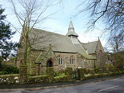
St Peters Church, Lindal in Furness (geograph 3241079).jpg
St. Peter's Church, Lindal-in-Furness
Location map United Kingdom Borough of Barrow-in-Furness.svg
Red pog.svg
Lindal-in-Furness
Location in Barrow-in-Furness Borough
Cumbria UK location map.svg
Red pog.svg
Lindal-in-Furness
Location within Cumbria
Population755 (2011 parish) [1]
OS grid reference SD250756
Civil parish
Unitary authority
Ceremonial county
Region
Country England
Sovereign state United Kingdom
Post town ULVERSTON
Postcode district LA12
Dialling code 01229
Police Cumbria
Fire Cumbria
Ambulance North West
UK Parliament
List of places
UK
England
Cumbria
54°10′16″N3°08′56″W / 54.171°N 3.149°W / 54.171; -3.149

Lindal-in-Furness is a village on the Furness peninsula, in the Westmorland and Furness district of Cumbria, England. Historically in Lancashire, it lies eight miles to the north-east of Barrow-in-Furness, on the A590 trunk road. The civil parish is Lindal and Marton which had a population of 755 at the 2011 Census, and includes the village of Marton. [1]

Contents

The land around Lindal, a small grange belonging to Furness Abbey in the Middle Ages, had long been known for its iron ore. In the 1840s and 1850s, larger deposits were discovered in the area [ citation needed ] and Lindal became one of many mining villages supplying the iron ore for what was then one of the world's largest steelworks, in Barrow.[ citation needed ]

Lindal was originally built around a tarn, which was later filled in with spoil from the mines to create a village green. The iron mining companies built houses, chapels, reading rooms, a public hall and a school in Lindal during the period from the mid-19th century to early 20th century.

The iron ore production declined in face of increased international competition and dwindling resources. The last mine in Lindal closed in 1960. Since then, Lindal has developed as a commuter village for the nearby towns of Barrow-in-Furness, Dalton-in-Furness and Ulverston.

Lindal and the adjacent village of Marton share a common Parish Council, Residents' Association, church and village hall. Lindal and Marton Primary School (LAMPS) celebrated its 150th anniversary in 2004.[ citation needed ]

Sport

Lindal Moor Cricket Club play in the North Lancashire and Cumbria League.

See also

Related Research Articles

<span class="mw-page-title-main">Millom</span> Town and parish in England

Millom is a town and civil parish on the north shore of the estuary of the River Duddon in southernmost Cumberland, Cumbria, England. It is situated just outside the Lake District National Park, about six miles north of Barrow-in-Furness and 26 mi (42 km) south of Whitehaven.

<span class="mw-page-title-main">Barrow-in-Furness</span> Town in Cumbria, England

Barrow-in-Furness is a port town and civil parish in the Westmorland and Furness district of Cumbria, England. Historically in Lancashire, it was incorporated as a municipal borough in 1867 and merged with Dalton-in-Furness Urban District in 1974 to form the Borough of Barrow-in-Furness. The borough was merged into the new Westmorland and Furness district in 2023. At the tip of the Furness peninsula, close to the Lake District, it is bordered by Morecambe Bay, the Duddon Estuary and the Irish Sea. In 2021, Barrow's population was 55,489, making it the second largest urban area in Cumbria after Carlisle, and the largest in the Westmorland and Furness unitary authority.

<span class="mw-page-title-main">Carnforth</span> Town and civil parish in Lancashire, England

Carnforth is a market town and civil parish in the City of Lancaster in Lancashire, England, situated at the north-east end of Morecambe Bay. The parish of Carnforth had a population of 5,560 in the 2011 census, an increase from the 5,350 recorded in the 2001 census. The town is situated around 7 miles north of Lancaster, 17 miles south of Kendal, 40 miles east of Barrow-in-Furness and 28 miles north-west of Settle. The town is also close to the Cumbria/Lancashire border.

<span class="mw-page-title-main">Furness Railway</span> English railway company

The Furness Railway (Furness) was a railway company operating in the Furness area of Lancashire in North West England.

<span class="mw-page-title-main">Swarthmoor</span> Human settlement in England

Swarthmoor is a small village near Ulverston, in Cumbria, England. Located on the Furness peninsula, it was historically part of Lancashire.

<span class="mw-page-title-main">Furness</span> Peninsula and region of Cumbria, England

Furness is a peninsula and region of Cumbria, England. Together with the Cartmel Peninsula it forms North Lonsdale, historically an exclave of Lancashire. On 1 April 2023 it became part of the new unitary authority of Westmorland and Furness.

<span class="mw-page-title-main">Dalton-in-Furness</span> Town in Cumbria, England

Dalton-in-Furness is a town in Westmorland and Furness, Cumbria, England, 4 miles (6 km) north east of Barrow-in-Furness. Along with the rest of the Furness peninsula, it was historically part of Lancashire. It is in the parish of Dalton Town with Newton, alongside the nearby hamlet of Newton-in-Furness. In 2011 it had a population of 7,827.

<span class="mw-page-title-main">Haverthwaite</span> Village in Cumbria, England

Haverthwaite is a small village and civil parish in the Furness region of Cumbria, England. It is also within the boundaries of the Lake District National Park. It is located several miles east of Ulverston and is near to the southern end of Windermere. In the 2001 census, the parish had a population of 728, which increased to 797 by 2011.

<span class="mw-page-title-main">Roose</span> Human settlement in England

Roose or Roosecote is a suburb and former ward of Barrow-in-Furness, Cumbria, England. The word 'roose' is Celtic for "moor" or "heath" and the suffix 'cote' of Roosecote means "hut" or "huts". Before the building of Roose Cottages and the arrival of the Cornish miners Roose was pronounced with a hard S, as in goose; now it is locally pronounced 'Rooze', due to the Cornish accent. Roose is served by Roose railway station, one of the few remaining stations on the Furness Line in the Barrow area.

<span class="mw-page-title-main">Egremont, Cumbria</span> Town and parish in England

Egremont is a market town, civil parish and two electoral wards in Cumbria, England, and historically part of Cumberland. It is situated just outside the Lake District National Park, five miles south of Whitehaven and on the River Ehen.

<span class="mw-page-title-main">Coniston, Cumbria</span> Village and parish in England

Coniston is a village and civil parish in the Westmorland and Furness district of Cumbria, England. In the 2001 census the parish had a population of 1,058, decreasing at the 2011 census to 928. Within the boundaries of the historic county of Lancashire, it is in the southern part of the Lake District National Park, between Coniston Water, the third longest lake in the Lake District, and Coniston Old Man.

<span class="mw-page-title-main">Aldingham</span> Village in Cumbria, England

Aldingham is a village and civil parish in the Westmorland and Furness Unitary Authority of Cumbria, England. Historically in Lancashire, it is situated on the east coast of the Furness peninsula, facing into Morecambe Bay, and is about 8 miles (13 km) east of Barrow-in-Furness, and 6 miles (9.7 km) south of Ulverston. The parish includes the nearby villages of Baycliff, Dendron, Leece, Gleaston, Newbiggin, Roosebeck, Scales and a number of smaller hamlets. According to the 2001 census the parish had a population of 1,187, reducing to 1,105 at the 2011 Census.

<span class="mw-page-title-main">Allithwaite</span> Village in England

Allithwaite is a village in Cumbria, England, located roughly 1.2 miles (1.9 km) west of Grange-over-Sands. Within the boundaries of the historic county of Lancashire, Allithwaite, and the village of Cartmel situated to the north, are part of the civil parish of Lower Allithwaite. At the 2001 census, the parish had a population of 1,758, increasing to 1,831 at the 2011 Census.

<span class="mw-page-title-main">Askam and Ireleth</span> Civil parish in England

Askam and Ireleth is a civil parish close to Barrow-in-Furness in Westmorland and Furness, Cumbria, England. Historically part of Lancashire, it originally consisted of two separate coastal villages with different origins and histories which, in recent times, have merged to become one continuous settlement. In the 2001 census the parish had a population of 3,632, reducing at the 2011 census to 3,462.

The firm of Harrison Ainslie & Co. was a British firm of ironmasters and iron ore merchants, selling high quality haematite from their mines on Lindal Moor to smelters in Glasgow, Scotland, South Wales and the Midlands. From a 21st-century perspective, they are more interesting as the last operators of charcoal-fired blast furnaces in Great Britain. Their furnaces were stone-built, water-powered, and much smaller than the coke-fired furnaces of the same era.

<span class="mw-page-title-main">Long Marton</span> Human settlement in England

Long Marton is a village and civil parish in the Westmorland and Furness of the English county of Cumbria. In 2011 the population was 827.

<span class="mw-page-title-main">Edward Wadham</span>

Edward Wadham was appointed mineral agent to Walter Montagu Douglas Scott, 5th Duke of Buccleuch in 1851 and later, steward of the Manor of Plain Furness. He kept detailed diaries throughout his adult life, now in the possession of the Cumbria Archive Service, many of which cover the growth and development of the town of Barrow-in-Furness, then in Lancashire now in Cumbria, England.

Lindal railway station served Lindal-in-Furness in the Furness area of Lancashire, England .

<span class="mw-page-title-main">Dalton Town with Newton</span> Human settlement in England

Dalton Town with Newton is a civil parish in Westmorland and Furness Unitary Authority, in the county of Cumbria, England. The parish includes the town of Dalton-in-Furness and the hamlet of Newton. In 2011 it had a population of 8,125. The parish touches Aldingham, Askam and Ireleth, Lindal and Marton and Urswick.

References

  1. 1 2 UK Census (2011). "Local Area Report – Lindal and Marton Parish (E04002444)". Nomis. Office for National Statistics . Retrieved 25 April 2021.