Barrow-in-Furness is a port town and civil parish in the Westmorland and Furness district of Cumbria, England. Historically in Lancashire, it was incorporated as a municipal borough in 1867 and merged with Dalton-in-Furness Urban District in 1974 to form the Borough of Barrow-in-Furness. The borough was merged into the new Westmorland and Furness district in 2023. At the tip of the Furness peninsula, close to the Lake District, it is bordered by Morecambe Bay, the Duddon Estuary and the Irish Sea. In 2021, Barrow's population was 55,489, making it the second largest urban area in Cumbria after Carlisle, and the largest in the Westmorland and Furness unitary authority.
Roa Island lies just over half a mile (1 km) south of the village of Rampside at the southernmost point of the Furness Peninsula in Cumbria, formerly in the county of Lancashire north of the sands. It is located at 54°5′N3°10′W. It is one of the Islands of Furness in northern England. It has an area of about three hectares.

Roose or Roosecote is a suburb and ward of Barrow-in-Furness, Cumbria, England. The word 'roose' is Celtic for "moor" or "heath" and the suffix 'cote' of Roosecote means "hut" or "huts". Before the building of Roose Cottages and the arrival of the Cornish miners Roose was pronounced with a hard S, as in goose; now it is locally pronounced 'Rooze', due to the Cornish accent. Roose is served by Roose railway station, one of the few remaining stations on the Furness Line in the Barrow area.

Barrow Island is an area and electoral ward of Barrow-in-Furness, Cumbria, England. Originally separate from the British mainland, land reclamation in the 1860s saw the northern fringes of the island connected to Central Barrow. Barrow Island is also bound to the south and east by the town's dock system and to the west by Walney Channel. The Ward population taken at the 2011 census was 2,616.

Abbey House on Abbey Road, Barrow-in-Furness, Cumbria, England is a Neo-Elizabethan H-plan mansion designed by Sir Edwin Lutyens and completed in 1914 as a guest house for Vickers Ltd and a flat for the Managing Director, Sir James McKechnie.

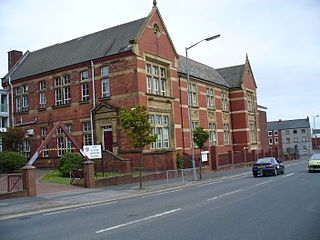
The Higher Grade School building in Barrow-in-Furness, Cumbria, England is Grade II listed and has functioned as a number of educational institutions throughout its long history. From completion until 1930 the building was occupied by the Barrow Higher Grade School.

Hindpool is an area and electoral ward of Barrow-in-Furness, Cumbria, England. It is bordered by Barrow Island, Central Barrow, Ormsgill, Parkside and the Walney Channel, the local population stood at 5,851 in 2011. The ward covers the entire western half of the town centre and includes Barrow's main shopping district. Other local landmarks include the Furness College Channelside campus, the Dock Museum and the Main Public Library. Hindpool is also home to two stadia - Barrow Raiders' Craven Park and Barrow A.F.C.'s Holker Street.

Abbey Road is the principal north to south arterial road through Barrow-in-Furness, Cumbria, England.

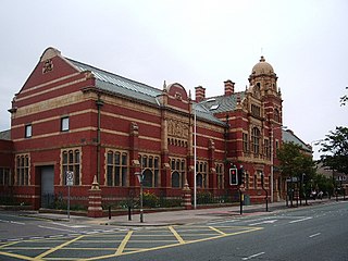
Barrow-in-Furness Main Public Library is a Grade II listed Beaux-Arts style building located at Ramsden Square, Barrow-in-Furness, England. Operated since 1974 by Cumbria County Council, it is the largest library in the town and the present structure, designed by J A Charles was originally built as a Carnegie library with support from the Carnegie Foundation.

The Nan Tait Centre is a Grade II listed building located at Abbey Road in the Hindpool area of Barrow-in-Furness, Cumbria, England.

The Furness Abbey Hotel was demolished in 1953, having been bombed in May 1941. Its site now forms the car park to Furness Abbey and the museum. The station at Furness Abbey also suffered bomb damage and was demolished in the early 1950s. The original station booking office and refreshment room, built in 1862, which had been attached to the hotel, survives as The Abbey Tavern, standing in Abbey Approach, Barrow-in-Furness, Cumbria, England, to the north of the remains of Furness Abbey. The current structure is recorded in the National Heritage List for England as a designated Grade II listed building.

The National Westminster Bank building in Barrow-in-Furness, Cumbria, England is located at the intersection of Abbey Road and Duke Street. It was designed by Paley and Austin architects and built between 1873–74 and has been designated a Grade II listed building by English Heritage. Built for the Lancaster branch of the National Westminster Bank it was a major component of the Ramsden Square scheme, one of the planned town's two main squares and focal points. It is one of three former 'Nat West' properties with listed building status in the Borough and currently houses a carpet shop in the lower floors.

Abbot's Wood was a large country house and estate located to the north-northeast of Barrow-in-Furness, Cumbria, England. It was sited on elevated ground to the northeast of Furness Abbey. The house was surrounded by extensive grounds with footpaths providing fine views.

Furness Abbey is a former railway station in the Barrow-in-Furness area of the Furness Peninsula, England.

Ramsden Hall located at 48 Abbey Road in Barrow-in-Furness, Cumbria, England is a Grade II listed former public bath house. Funded by industrialist and local mayor Sir James Ramsden it was constructed in 1872 and was relatively small in comparison to other public baths in Barrow. Despite no longer serving its original purpose Ramsden Hall stands as the only remaining example of a 19th-century public bath in the town. For a period of its history, the building served as an annexe of the adjacent Technical School although at present it is occupied by offices of the Citizens Advice Bureau.

The Custom House in Barrow-in-Furness, Cumbria, England is a former government building, having housed the customs offices for trade handled at the Ports of Barrow and Lancaster. Initially constructed as a hotel around 1870, it took on its most notable role as a custom house in 1880, regulating custom from the Port of Lancaster.
St. George's Square, in Barrow-in-Furness, Cumbria, England is a public space that acted as the centre of the town during the late 19th century. The square now lies in the southernmost fringes of the Central ward close to the Port of Barrow.

Ramsden Square is a square located at the intersection of Abbey Road and Duke Street in Barrow-in-Furness, Cumbria, England. It marks the boundary of the Central and Hindpool wards and now acts as a major roundabout. Ramsden Square was first laid out in the 1840s to act as a focal point of Sir James Ramsden's master plan for the new town of Barrow, separating its burgeoning industries and commercial core. The centerpiece of the square is a statue of Ramsden himself while it is framed by a number of historic buildings including Barrow Central Library, the National Westminster Bank Building and formerly the Barrow Jute Works.

Barrow-in-Furness Strand railway station was the first permanent railway terminus to be built in Barrow-in-Furness, England. Located on the Strand at St. George's Square close to the town's docks its functioning life was short, however the building itself continued to be used as the headquarters of the Furness Railway for a number of years. The station opened in 1863 having replaced a wooden structure which was erected in 1846 at adjacent Rabbit Hill. The station at St. George's square ceased commercial operations in 1882 upon the completion of a new loop line and much larger station at Abbey Road. Barrow-in-Furness Central railway station, later simply renamed Barrow-in-Furness railway station has been the town's primary station ever since.

Abbey Road Working Men's Club is a partially destroyed Grade II listed building located at Abbey Road close to Ramsden Square in Barrow-in-Furness, Cumbria, England. Design by architect Henry Darbishire it was completed in 1871 and extended in the early 20th century, notable features previously included an ornate hipped roof with multiple oval dormers and an engraving of the Borough Coat of Arms. During the building's lifetime it functioned as a social club and later public house.


