 | |
|---|---|
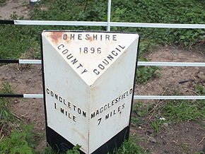 Milestone on the junction of the A537 and Havannah Lane | |
| Route information | |
| Length | 7.4 mi [1] (11.9 km) |
| Major junctions | |
| North end | Macclesfield |
| South end | Congleton |
| Road network | |
The A536 road links the Cheshire towns of Congleton and Macclesfield.
| | |
|---|---|
| Milestone on the junction of the A537 and Havannah Lane | |
| Route information | |
| Length | 7.4 mi [1] (11.9 km) |
| Major junctions | |
| North end | Macclesfield |
| South end | Congleton |
| Road network | |
The A536 road links the Cheshire towns of Congleton and Macclesfield.
Starting at the junction with the A34 in Lower Heath, Congleton, the road travels through the villages of Eaton and Gawsworth before entering Macclesfield. Once into Macclesfield, it take a right turn at the traffic lights by the Flower Pot public house, becoming Park Lane.
Passing the Learning Zone (Macclesfield College and The Macclesfield Academy) it travels to the end of Park Lane, veering right at a roundabout to become Park Street. After a short distance, the road turns right at the Park Green traffic lights and runs a short distance to join the A523 Mill Lane / The Silk Road at a T junction controlled by traffic lights.
The Congleton Link Road, which was completed in 2021, continues the A536 from just south of Eaton to join the A534 Sandbach Road, bypassing Congleton to the north. [2]
Between Eaton and Gawsworth, there are three places in the space of 4 miles now signposted as lay-bys which used to be the original course of the A536 but which have been left in place as stopping areas following straightening of the road.
Closer to Gawsworth, the road used to pass immediately in front of the Harrington Arms public house and then take a right angle turn around the pub. This original route can be seen when examining Cheshire Tithe Maps. [3]
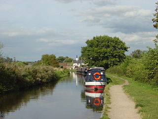
The Trent and Mersey Canal is a 93+1⁄2-mile (150 km) canal in Derbyshire, Staffordshire and Cheshire in north-central England. It is a "narrow canal" for the vast majority of its length, but at the extremities to the east of Burton upon Trent and north of Middlewich, it is a wide canal.
Congleton is a town and civil parish in the unitary authority of Cheshire East in Cheshire, England. The town is by the River Dane, 21 miles (34 km) south of Manchester and 13 miles (21 km) north of Stoke on Trent. At the 2011 Census, it had a population of 26,482.

The M56 motorway, also known as the North Cheshire motorway, serves the Cheshire and Greater Manchester areas of England. It runs east-west from Junction 4 of the M60 at Gatley, south of Manchester, to Dunkirk, approximately four miles north of Chester. With a length of 33.3 miles (53.6 km), it connects North Wales and the Wirral peninsula with much of the rest of North West England, serves business and commuter traffic heading towards Manchester, particularly that from the wider Cheshire area, and provides the main road access to Manchester Airport from the national motorway network, being easily accessible from the M6 and M62.

The A52 is a major road in the East Midlands, England. It runs east from a junction with the A53 at Newcastle-under-Lyme near Stoke-on-Trent via Ashbourne, Derby, Stapleford, Nottingham, West Bridgford, Bingham, Grantham, Boston and Skegness to the east Lincolnshire coast at Mablethorpe. It is approximately 147 miles (237 km) long.

Macclesfield is a constituency currently represented in the House of Commons of the UK Parliament since 2010 by David Rutley, a Conservative.

The Macclesfield Canal is a canal in east Cheshire, England. There were various proposals for a canal to connect the town of Macclesfield to the national network from 1765 onwards, but it was not until 1824 that a scheme came to fruition. There were already suggestions by that date that a railway would be better, but the committee that had been formed elected for a canal, and the engineer Thomas Telford endorsed the decision. The canal as built was a typical Telford canal, constructed using cut and fill, with numerous cuttings and embankments to enable it to follow as straight a course as possible, although Telford had little to do with its construction, which was managed by William Crosley.

Wanneroo Road is a 44-kilometre (27 mi) arterial highway in the northern suburbs of Perth, Western Australia linking Joondanna and Yokine in the south with Wanneroo and Yanchep in the north. As part of State Route 60, it begins from Charles Street in the inner city and becomes Indian Ocean Drive up to Dongara.

The A453 road was formerly the main trunk road connecting the English cities of Nottingham and Birmingham. However, the middle section of this mainly single-carriageway road has largely been downgraded to B roads or unclassified roads following the construction of the parallel M42-A42 link around 1990. The M42 was originally meant to pass further north than it does, and to join the M1 at Sandiacre in Derbyshire. The M42/A42 does not enter Derbyshire, but instead joins the M1 closer to the A453 junction at Kegworth. The A42 shadows the former A453 from Appleby Magna to Castle Donington. The road historically connected the East Midlands with the West Midlands.

The A54 road is a road in England linking Chester in Cheshire with Buxton in Derbyshire. Its route through both urban and steep rural areas presents a challenge to Cheshire County Council in maintaining the safety of the road. Many years ago it was the main east–west route in Cheshire. The importance of the A54 through Middlewich and Winsford decreased in the 1970s and 1980s with the building of the M56 motorway and dualling of the A556 at Northwich. The section through Winsford carries approximately 30,000 vehicles per day.

The B5470 is a road in England, running from Chapel-en-le-Frith, Derbyshire, to Macclesfield, Cheshire, via Whaley Bridge. The hilly and winding section between Whaley Bridge and Macclesfield is often called 'The Highwayman' after a prominent roadside pub, now closed. Much of the route follows former turnpike roads through a scenic area of the Peak District National Park.

The Cat and Fiddle is a road in England between Buxton, Derbyshire, and Macclesfield, Cheshire, named after the Cat and Fiddle Inn public house at its summit. Formed by parts of the A537, A54 and A53, it is famous for its scenic views across the Greater Manchester conurbation, the Peak District National Park and the Cheshire Plain, and for its many bends. It is extremely popular with motorcyclists, and is often classed as the most dangerous road in the United Kingdom.

The A556 is a road in England which extends from the village of Delamere in Cheshire West and Chester to the Bowdon Interchange in Cheshire East, bordering Greater Manchester. The road contains a mixture of single and dual carriageway sections and forms a large part of the route between Manchester and Chester. It also acts as a major access route to Chester/North Wales to the west and to Manchester to the east for the conurbation of towns and villages around the Dane Valley centering on Winsford and Northwich. The central part, which forms the Northwich Bypass between Davenham and Lostock Gralam, suffers because of the amount of commuter traffic from this area. The part of the route between the M6 motorway Junction 19 and the M56 motorway Junction 7 is a major route into Manchester and has been recently upgraded to a four-lane dual carriageway.

The A537 is a road linking Knutsford, in Cheshire, and Buxton, in Derbyshire. Part of the route includes the Cat and Fiddle Road, one of the most dangerous in Great Britain.

The A538 is a road in England linking Macclesfield, Cheshire to Altrincham in Greater Manchester, through Prestbury, Wilmslow and Hale and providing access to Manchester Airport and the M56 motorway. The road is a Primary route between the A34 Junction in Wilmslow and Manchester Airport / M56 motorway.

A large number of canals were built in Cheshire, England, during the early phases of the Industrial Revolution to transport goods and raw materials. This resulted in a significant canal network which is now enjoyed by holiday-makers, anglers, walkers, and others.

Cheshire East is a unitary authority area with borough status in the ceremonial county of Cheshire, England. The local authority is Cheshire East Council. The main towns within the area are Crewe, Macclesfield, Congleton, Sandbach, Wilmslow, Knutsford and Nantwich. The council is based in Sandbach.

The A535 road is a non-primary route in England that runs from Holmes Chapel, Cheshire to Alderley Edge, Cheshire. It passes through the Dane River valley. It is the main road that gives access to the Jodrell Bank Observatory and the Quinta Arboretum, planted by Sir Bernard Lovell in 1948.

Christ Church is in Macclesfield Road, the A536 road, to the south of the village of Eaton, Cheshire East, England. It is an active Anglican parish church in the deanery of Congleton, the archdeaconry of Macclesfield, and the diocese of Chester. Its benefice is combined with those of St James and St Paul, Marton, All Saints, Siddington, and Holy Trinity, Capesthorne. The church is recorded in the National Heritage List for England as a designated Grade II listed building.
A roads in Zone 5 of the Great Britain road numbering scheme | ||
|---|---|---|