The A6 is one of the main historic north–south roads in England. It runs from Luton in Bedfordshire to Carlisle in Cumbria, although it formerly started at a junction with the A1 at Barnet. It is the fourth longest numbered road in Britain; only the A1, A38 and A30 are longer.

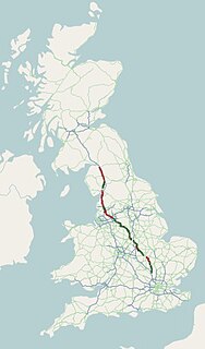
The A59 is a major road in England which is around 109 miles (175 km) long and runs from Wallasey, Merseyside to York, North Yorkshire. The alignment formed part of the Trunk Roads Act 1936, being then designated as the A59. It is a key route connecting Merseyside at the M53 motorway to Yorkshire, passing through three counties and connecting to various major motorways. The road is a combination of historical routes combined with contemporary roads and a mixture of dual and single carriageway. Sections of the A59 in Yorkshire closely follow the routes of Roman roads, some dating back to the Middle Ages as salt roads, whilst much of the A59 in Merseyside follows Victorian routes which are largely unchanged to the present day.
Prince's Park in Toxteth, Liverpool, England, is a 45 ha municipal park, 2 mi (3.2 km) south east of Liverpool city centre. In 2009, its status was upgraded to a Grade II* Historic Park by English Heritage.

Burscough is a town and civil parish in West Lancashire in the ceremonial county of Lancashire, England. It is located to the north of Ormskirk and northwest of Skelmersdale.

St Michael's Church, also known as St Michael-in-the-Hamlet Church, is in St. Michael's Church Road, St Michael's Hamlet, Liverpool, Merseyside, England. It is recorded in the National Heritage List for England as a designated Grade I listed building. The church contains much cast iron in its structure, and its citation in the National Heritage List for England states it has "one of the earliest and most thorough uses of industrial materials in a major building". It is an active Anglican parish church in the diocese of Liverpool, the archdeaconry of Liverpool, and the deanery of Toxteth and Wavertree. Its benefice is united with those of Christ Church, Toxteth Park, and St Andrew, Liverpool.

Anfield Cemetery, or the City of Liverpool Cemetery, is located in Anfield, a district of Liverpool, Merseyside, England. It lies to the northeast of Stanley Park, and is bounded by Walton Lane to the west, Priory Road to the south, a railway line to the north, and the gardens of houses on Ince Avenue to the east. The cemetery grounds are included in the National Register of Historic Parks and Gardens at Grade II*.

Herbert James Rowse was an English architect. Born in Liverpool and a student of Charles Reilly at the Liverpool University School of Architecture, Rowse opened an architectural practice in the city. Although he designed major buildings for other cities, Rowse is best known for his work in Liverpool, including India Buildings, the entrances to and ventilation towers of the Mersey Tunnel ("Queensway"), and the Philharmonic Hall. He designed in a range of styles, from neoclassical to Art Deco, generally with a strong American influence.

Halsall is a village and civil parish in West Lancashire, England, located close to Ormskirk on the A5147 and Leeds and Liverpool Canal.
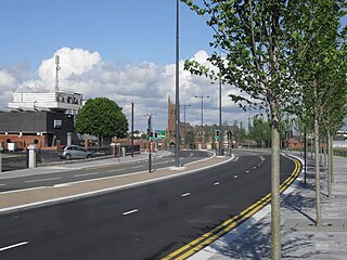
Edge Lane is a main road running from the periphery of Liverpool city centre at Hall Lane towards the M62 motorway. Edge Lane technically comprises two roads, that of 'Edge Lane' and that of 'Edge Lane Drive' and passes through the districts of Old Swan, Kensington, Wavertree and Edge Hill. It forms part of the A5047.

The architecture of Liverpool is rooted in the city's development into a major port of the British Empire. It encompasses a variety of architectural styles of the past 300 years, while next to nothing remains of its medieval structures which would have dated back as far as the 13th century. Erected 1716–18, Bluecoat Chambers is supposed to be the oldest surviving building in central Liverpool.

The A749 road in Scotland connects East Kilbride with Glasgow city centre via Rutherglen and Bridgeton.

There are over 2500 listed buildings in Liverpool, England. A listed building is one considered to be of special architectural, historical or cultural significance, which is protected from being demolished, extended or altered, unless special permission is granted by the relevant planning authorities. Of the listed buildings in Liverpool, 27 are classified as Grade I listed and are recognised as buildings of outstanding architectural or historic interest. The following list provides information on all the Grade I listed buildings in the city.
There are over 2500 listed buildings in Liverpool, England. A listed building is one considered to be of special architectural, historical or cultural significance, which is protected from being demolished, extended or altered, unless special permission is granted by the relevant planning authorities. Of the listed buildings in Liverpool, at least 85 are classified as Grade II* listed and are recognised as being particularly important with more than special architectural or historic interest. The following list provides information on all the Grade II* listed buildings located in all the L postcodes outside the city centre.

Kingsway is a dual carriageway in Greater Manchester, England, which runs from Levenshulme to Cheadle. It is approximately 7.3 miles long and is a link road between the city centre and the southern suburbs of Greater Manchester, forming part of the A34. Kingsway was built in the late 1920s between Levenshulme and Parrs Wood, and was originally designed as a combined road and tram route. The tram tracks were eventually removed and the road was later extended to bypass Cheadle and join onto the M60 motorway.

Merseyside is a metropolitan county in North West England. It was created by the Local Government Act 1972, and consists of the metropolitan boroughs of Knowsley, St Helens, Sefton, Wirral, and the city of Liverpool. Buildings are listed on the recommendation of English Heritage to the Secretary of State for Culture, Media and Sport, who makes the decision whether or not to list the structure. Grade I listed buildings are defined as being of "exceptional interest, sometimes considered to be internationally important"; only 2.5 per cent of listed buildings are included in this grade. This is a complete list of Grade I listed churches in the metropolitan county of Merseyside as recorded in the National Heritage List for England.
Culshaw and Sumners was a firm of English architects and surveyors who practised in Liverpool in the 19th and early 20th centuries. The work of the practice reflected the growing economic prosperity of the city during this period. Much of its work was routine and mundane, but it did produce some notable buildings, including office blocks, warehouses, domestic properties, workhouses, churches, and a hospital. The firm was established by 1839 by William Culshaw, who was joined by Henry Sumners in 1861. Following Culshaw's death in 1874, the practice was continued until 1916 by his son, Alfred.

John Cragg was an English ironmaster who ran a foundry in Liverpool, Merseyside, England. He was born in Warrington. His business was the Merseyside Iron Foundry, which was located in Tithebarn Street, Liverpool. Cragg was an enthusiast in the use of prefabricated ironwork in the structure of buildings, and in the early 19th century became interested in building churches. He had been discussing building a church in Toxteth Park, Liverpool, and in 1809 plans had been drawn up for this by J. M. Gandy. This church was never built, but in 1812 Cragg met Thomas Rickman, and together they designed the three churches in Liverpool incorporating Cragg's cast iron elements. The first of these was St George's Church, Everton (1813–14). The exterior of this church is largely in stone, but the framework of its interior, including the galleries, and the window tracery are in cast iron. The ceilings consist of slate slabs supported by cast iron rafters, which are decorated with cast iron tracery. The second church resulting from this collaboration was St Michael's Church, Aigburth (1813–15), Here, in addition to the cast iron framework of the interior, and the window tracery, the parapets, battlements, pinnacles, hoodmoulds, the dado, and other details are also in cast iron. The area around the church, known as St Michael's Hamlet contains five villas containing many cast iron features. The third cast iron church was St Philip's Church (1815–16) in Hardman Street, Liverpool, which was closed in 1882 and demolished. Some cast iron fragments have been incorporated in the fabric of the block of buildings now occupying the site of the churchyard. Cragg died on 17 July 1854, aged 87, and was buried in St James Cemetery, Liverpool.

Christ Church, Toxteth Park, is in Linnet Lane, Liverpool, Merseyside, England. It is an active Anglican parish church in the deanery of Wavertree and Toxteth, the archdeaconry of Liverpool, and the diocese of Liverpool. Its benefice is united with that of St Michael, Aigburth. The church is recorded in the National Heritage List for England as a designated Grade II listed building.
The city of Liverpool in Merseyside, England includes a diverse variety of historical housing architectures, some dating back several hundred years, from small working class terrace houses to larger mansions, mostly from the Victorian era. While many remain in the present day, large numbers were demolished and redeveloped during the slum clearances of the 1960s and 1970s and of those that survived, many have since been refurbished.

