
The River Goyt is a tributary of the River Mersey in North West England.

The Upper Goyt Valley is the southern section of the valley of the River Goyt in North West England.

The A6 is one of the main north–south roads in England. It runs from Luton in Bedfordshire to Carlisle in Cumbria, although it formerly started at a junction with the A1 at Barnet. It is the fourth longest numbered road in Britain; only the A1, A38 and A30 are longer.
New Mills is a town in the Borough of High Peak, Derbyshire, England, 8 miles (13 km) south-east of Stockport and 13 miles (21 km) from Manchester at the confluence of the River Goyt and Sett. It is close to the border with Cheshire and above the Torrs, a 70 feet (21 m) deep gorge cut through carboniferous sandstone, on the north-western edge of the Peak District national park.

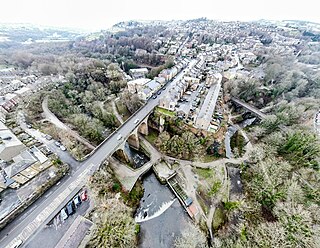
Whaley Bridge is a town and civil parish in the High Peak district of Derbyshire, England. It is situated on the River Goyt, 16 miles (26 km) south-east of Manchester, 7 miles (11 km) north of Buxton, 9 miles (14 km) north-east of Macclesfield and 28 miles (45 km) west of Sheffield. It had a population of 6,455 at the 2011 census, including Furness Vale, Horwich End, Bridgemont, Fernilee, Stoneheads and Taxal.

The Cromford and High Peak Railway (C&HPR) was a standard-gauge line between the Cromford Canal wharf at High Peak Junction and the Peak Forest Canal at Whaley Bridge. The railway, which was completed in 1831, was built to carry minerals and goods through the hilly rural terrain of the Peak District within Derbyshire, England. The route was marked by a number of roped worked inclines. Due to falling traffic, the entire railway was closed by 1967.

The A53 is a primary route in the English Midlands, that runs from Buxton in Derbyshire to Shrewsbury in Shropshire.

The Midshires Way is a long-distance footpath and bridleway that runs for 230 miles (370 km) from the Chiltern Hills from near Bledlow in Buckinghamshire, through the Midlands counties of Northamptonshire, Leicestershire, Nottinghamshire and Derbyshire, to Stockport, Greater Manchester. It also links several other long-distance walking routes or trackways including The Ridgeway, the Pennine Bridleway and the Trans Pennine Trail.

Furness Vale is a village in the High Peak district of Derbyshire, England, between New Mills and Whaley Bridge. It is bisected by the A6 road and the Peak Forest Canal, whose towpath is followed by the Goyt Way, part of the 230-mile (370 km) Midshires Way. It comes under the administration of Whaley Bridge town council and has a population of approximately 1,500.

The Buxton line is a railway line in Northern England, connecting Manchester with Buxton in Derbyshire. Passenger services on the line are currently operated by Northern Trains.

The A54 road is a road in England linking Chester in Cheshire with Buxton in Derbyshire. Its route through both urban and steep rural areas presents a challenge to Cheshire County Council in maintaining the safety of the road. Many years ago it was the main east–west route in Cheshire. The importance of the A54 through Middlewich and Winsford decreased in the 1970s and 1980s with the building of the M56 motorway and dualling of the A556 at Northwich. The section through Winsford carries approximately 30,000 vehicles per day.
New York State Route 52 (NY 52) is a 108.72-mile-long (174.97 km) state highway in the southeastern part of the state. It generally runs from west to east through five counties, beginning at the Pennsylvania state line in the Delaware River near Narrowsburg, crossing the Hudson River on the Newburgh–Beacon Bridge, and ending in Carmel. NY 52 and NY 55, both major east–west routes of the Mid-Hudson Region, run parallel to each other, intersecting in downtown Liberty.

The Cat and Fiddle is a road in England between Buxton, Derbyshire and Macclesfield, Cheshire, named after the Cat and Fiddle Inn public house at its summit. Formed by parts of the A537, A54 and A53, it is famous for its scenic views across the Greater Manchester conurbation, the Peak District National Park and the Cheshire Plain, and for its many bends. It is extremely popular with motorcyclists, and is often classed as the most dangerous road in the United Kingdom.

The A537 is a road linking Knutsford, in Cheshire, and Buxton, in Derbyshire. Part of the route includes the Cat and Fiddle Road, one of the most dangerous roads in Great Britain.

The A624 road is a main road in the English county of Derbyshire. It connects Glossop to Chapel-en-le-Frith passing through Chunal, Hayfield, and New Smithy.
The Stockport, Disley and Whaley Bridge Railway was an early railway company in England which was opened in 1857 between Stockport Edgeley and Whaley Bridge.
Shallcross is a small village in northwestern Derbyshire, England. It is located 15 miles (24 km) south of Manchester, at the edge of the Peak District, on the eastern side of the River Goyt. Located between Whaley Bridge and Fernilee, it is now administered as part of the larger community of Whaley Bridge. The area attracts many outdoors enthusiasts, especially hikers, because of the beauty and variety of the scenery. The country rises steeply as it ascends the Goyt Valley from the canal terminal at Whaley Bridge, past the Fernilee Reservoir, and onto the highlands of Axe Edge Moor.
The Peak District Boundary Walk is a circular 190-mile (310 km) walking trail, starting and finishing at Buxton and broadly following the boundary of the Peak District, Britain's first national park. The route was developed by the Friends of the Peak District and was launched on 17 June 2017.

Fernilee Reservoir is a drinking-water reservoir fed by the River Goyt in the Peak District National Park, within the county of Derbyshire and very close to the boundary with Cheshire. The village of Fernliee sits at the north end of the reservoir, with Goyt's Moss to the south and between Hoo Moor to the west and Combs Moss to the east.
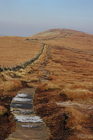
Cats Tor is a Peak District hill on the border between Cheshire and Derbyshire, between the towns of Macclesfield and Buxton. The summit is 518 metres (1,699 ft) above sea level. Tor is an Old English word for a high, rocky hill.


