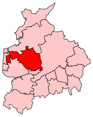
Wyre is a local government district with borough status on the coast of Lancashire, England. The council is based in Poulton-le-Fylde and the borough also contains the towns of Cleveleys, Fleetwood, Garstang, Preesall and Thornton, along with numerous villages and surrounding rural areas. Some of the borough's built-up areas form part of the wider Blackpool urban area. Eastern parts of the borough lie within the Forest of Bowland, a designated Area of Outstanding Natural Beauty.

Poulton-le-Fylde, commonly shortened to Poulton, is a market town in Lancashire, England, situated on the coastal plain called the Fylde. In the 2021 United Kingdom census, it had a population of 18,115.

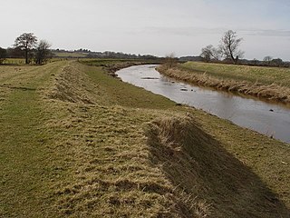
The Amounderness Hundred is one of the six subdivisions of the historic county of Lancashire in North West England, but the name is older than the system of hundreds first recorded in the 13th century and might best be described as the name of a Norse wapentake. In the Domesday Book of 1086, it was used for some territories north of the River Ribble included together with parts of Yorkshire. The area eventually became part of Lancashire, sitting geographically between the Rivers Lune and Ribble, in the strip of coast between the Irish Sea and Bowland Forest.
Wyre and Preston North is a county constituency represented in the House of Commons of the Parliament of the United Kingdom. Created in the most recent fifth periodic review of constituencies by the Boundary Commission for England, it elects one Member of Parliament (MP) by the first past the post voting system.

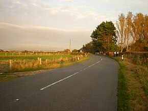
Hambleton is a village and civil parish in the English county of Lancashire. It is situated on a coastal plain called the Fylde and in an area east of the River Wyre known locally as Over Wyre. Hambleton lies approximately 3 miles (4.8 km) north-east of its post town, Poulton-le-Fylde, and about 7 miles (11 km) north-east of the seaside resort of Blackpool. In the 2001 United Kingdom census, the parish had a population of 2,678, increasing to 2,744 at the 2011 census.
The Fleetwood branch line is a railway line that ran from Preston to Fleetwood. It passed through many smaller stations along the way, most of which are now closed. When work at Fleetwood docks was under threat in the mid-1960s, the main Fleetwood station was closed, and the remainder of the branch south to Poulton followed in 1970. There are active proposals to re-open the branch to passenger services.
The Fylde is a coastal plain in western Lancashire, England. It is roughly a 13-mile-long (21-kilometre) square-shaped peninsula, bounded by Morecambe Bay to the north, the Ribble estuary to the south, the Irish Sea to the west, and the foot of the Bowland hills to the east which approximates to a section of the M6 motorway and West Coast Main Line.

Elswick is a rural village and civil parish on the Fylde coast of Lancashire, England. At the 2011 Census, it had a population of 1,079.

The A585 is a primary road in England which runs from Kirkham to Fleetwood in Lancashire.
Great Eccleston is a village and civil parish in Lancashire, England situated on a coastal plain called the Fylde. The village lies to the south of the River Wyre and the A586 road, approximately 10 miles (16 km) upstream from Fleetwood. At the 2001 census, the parish had a population of 1,473, rising slightly to 1,486 at the 2011 census.
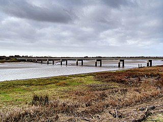
Shard Bridge is a bridge in the English county of Lancashire. It spans the River Wyre, connecting Singleton, on the southern side of the river, to Hambleton, on its northern side, carrying both automotive and pedestrian traffic of the A588 Shard Road. The word shard is a Roman term for "low crossing point on a river".

The A587 is a road in England that runs from Blackpool to Fleetwood in Lancashire.

The A586 is a road in England, which runs from Garstang to Blackpool, in Lancashire.
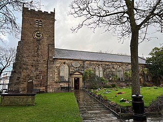
Poulton-le-Fylde is a market town in the Wyre district of Lancashire, England, situated on a coastal plain called the Fylde. There are 16 buildings and structures in the town which have been listed by the Secretary of State for Culture, Olympics, Media and Sport as being of special architectural, historical or cultural significance. One is classified as Grade II*, and the rest as Grade II; Poulton-le-Fylde has no Grade I listed buildings. The Grade II* designation is for St Chad's Church. There is written evidence of a church on the site since 1094, although it may have been built earlier. It became the Anglican parish church at the time of the Reformation and was largely rebuilt in the 18th century.

The Way of the Roses is the newest of Great Britain's coast-to-coast long-distance cycle routes and is based on minor roads, disused railway lines and specially constructed cycle paths. It lies entirely within the counties of Lancashire and Yorkshire, crossing the Yorkshire Dales and the Yorkshire Wolds in the North of England, passing through the historic cities of Lancaster, Ripon and York and scenic towns and villages including Settle and Pateley Bridge

Burn Naze is a residential area of Thornton-Cleveleys, in the Borough of Wyre, Lancashire, England. It is located about 5 miles (8 km) northeast of Blackpool and 2 miles (3 km) southeast of Fleetwood. Cleveleys is about 1.3 miles (2.1 km) to the west, while the River Wyre is about 0.8 miles (1.3 km) to the east.

Shard Riverside Inn is a public house and boutique hotel in the English village of Hambleton, Lancashire. Dating to 1766, it stands on the northern banks of the River Wyre, about 600 feet (180 m) east of Shard Bridge, for which it is named. The bridge used to be immediately to the west of the building, but a new structure was built in 1993, a few yards downstream, and its predecessor demolished. The building's address, Old Bridge Lane, references this.
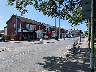
Victoria Road is a major thoroughfare in Thornton-Cleveleys, Lancashire, England. Originally known as Ramper Road, it runs for about 2 miles (3.2 km) from Station Road in Thornton, in the east, to South Promenade in Cleveleys, in the west. Its addresses are denoted as "Victoria Road East" or "Victoria Road East", the split occurring at the Amounderness Way roundabout carrying traffic of the A585 between Poulton-le-Fylde and Fleetwood. The road picks up the B5412 designation from Station Road until The Crescent and Brighton Avenue in Cleveleys.
Breck Road is a road in Poulton-le-Fylde, Lancashire, England. Originally known as Breck Street, it runs for about 0.79 miles (1.27 km) from Chapel Street, Ball Street and Vicarage Road in the south to Amounderness Way in the north.