Audlem is a village and civil parish located in Cheshire, North West England. In 2021, it had a population of 1,832.

Middlewich is a town in the unitary authority of Cheshire East and the ceremonial county of Cheshire, England. It is located 19.2 miles (30.9 km) east of Chester, 2.9 miles (4.7 km) east of Winsford, 5.3 miles (8.5 km) south-east of Northwich and 4.7 miles (7.6 km) north-west of Sandbach. The population at the 2011 Census was 13,595. Middlewich, together with Northwich and Winsford, forms part of the Central Cheshire conurbation, with an estimated 2023 population of 130,000.

The A54 road is a road in England linking Chester in Cheshire with Buxton in Derbyshire. Its route through both urban and steep rural areas presents a challenge to Cheshire County Council in maintaining the safety of the road. Many years ago it was the main east–west route in Cheshire. The importance of the A54 through Middlewich and Winsford decreased in the 1970s and 1980s with the building of the M56 motorway and dualling of the A556 at Northwich. The section through Winsford carries approximately 30,000 vehicles per day.
Baddington is a civil parish in the unitary authority of Cheshire East and the ceremonial county of Cheshire, England, which lies immediately to the south-west of Nantwich and north of Audlem. Predominantly rural with scattered farms, the civil parish has a total population of around 100 people, increasing to 212 at the 2011 Census, and includes the dispersed settlement of Hack Green, the site of a former RAF decoy station, radar station and Home Defence regional headquarters. Nearby villages include Aston, Broomhall Green, Hankelow, Ravensmoor, Sound Heath and Stapeley.

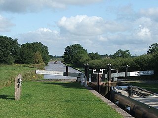
Broomhall is a civil parish in the unitary authority of Cheshire East and the ceremonial county of Cheshire, England. The main line of the Shropshire Union Canal runs through the parish and the River Weaver forms part of its boundary. The main settlement is the hamlet of Broomhall Green, which lies on the A530 about 3.5 miles (5.6 km) south-west of Nantwich. The civil parish has an area of 539 hectares, and also includes part of the small settlement of Sandford, with a total population of around 200 in 2011. Nearby villages include Aston, Sound, Wrenbury and Audlem. Broomhall appears in the Domesday survey and the name was also historically spelled Bromhall.

The A525 is a major route from Rhyl in Wales to Newcastle-under-Lyme in England. The route passes near Denbigh, through Ruthin, through Wrexham and near Whitchurch.
The First Battle of Middlewich took place on 13 March 1643, during the First English Civil War, and was fought between the Parliamentarians, under Sir William Brereton, and the Royalist supporters of King Charles I of England, under Sir Thomas Aston.

Greenbank railway station serves the village of Hartford, Cheshire as well as the Greenbank and Castle areas of Northwich, Cheshire, England. The station is situated on the A559 road from Northwich to Chester.
Middlewich is one of the Wich towns in Cheshire, England.

Cheshire East is a unitary authority area with borough status in Cheshire, England. The local authority is Cheshire East Council, which is based in the town of Sandbach. Other towns within the area include Crewe, Macclesfield, Congleton, Wilmslow, Nantwich, Poynton, Knutsford, Alsager, Bollington and Handforth.

Cholmondeston is a village and civil parish in the unitary authority of Cheshire East and the ceremonial county of Cheshire, England. The village lies 5 miles (8 km) to the northwest of Nantwich. Nearby villages include Aston juxta Mondrum, Barbridge, Calveley and Wettenhall. The Middlewich Branch of the Shropshire Union Canal and the Crewe–Chester railway line run through the civil parish. The area is predominantly rural, with a total population of around 150 in 2001, increasing to 175 at the 2011 Census.

Leighton is a scattered settlement and civil parish in the unitary authority of Cheshire East and the ceremonial county of Cheshire, England, which lies immediately north west of Crewe. The parish also includes the village of Barrows Green, which lies on the northern outskirts of Crewe, 1½ miles from the centre. Nearby villages include Bradfield Green and Worleston. The total population of the civil parish was 4,883 at the 2011 Census.

Minshull Vernon is a hamlet and civil parish in the unitary authority of Cheshire East and the ceremonial county of Cheshire, England. The hamlet lies 3 miles (5 km) to the north west of Crewe, south east of Winsford and south west of Middlewich. The parish also includes the small settlements of Bradfield Green, Eardswick, Hoolgrave, Minshull Hill, Walley's Green and Weaver Bank. The total population of the civil parish is somewhat over 200, measured at 391 in the Census 2011. Nearby villages include Church Minshull, Warmingham and Wimboldsley.
Sound is a hamlet and civil parish in the unitary authority of Cheshire East and the ceremonial county of Cheshire, England. The hamlet is located 3+1⁄4 miles (5.2 km) to the south west of Nantwich. The civil parish covers 1,089 acres (441 ha) and also includes the small settlements of Newtown and Sound Heath, with a total population at the 2011 census of 239. Nearby villages include Aston, Ravensmoor and Wrenbury.
Warmingham is a village and civil parish in the unitary authority of Cheshire East and ceremonial county of Cheshire, England, on the River Wheelock, 3.25 miles (5.23 km) north of Crewe, 3.25 miles (5.23 km) south of Middlewich and 3.25 miles (5.23 km) miles west of Sandbach. The parish also includes the small settlement of Lane Ends, with a total population of just under 250. Nearby villages include Minshull Vernon, Moston and Wimboldsley.

Coole Pilate is a civil parish in the unitary authority of Cheshire East and the ceremonial county of Cheshire, England, which lies to the north of Audlem and to the south of Nantwich. The area is predominantly rural with scattered farms, and a total population of 60 people. At the 2011 Census the population remained less than 100. Details are included in the civil parish of Austerson. Nearby villages include Broomhall Green, Hankelow, Hatherton and Newhall.

Occlestone Green is a small rural settlement in the civil parish of Stanthorne and Wimboldsley, the unitary authority of Cheshire West and Chester and the ceremonial county of Cheshire, England. Nearby settlements include the villages of Wimboldsley, Warmingham and Walley's Green. The nearest town is Middlewich.

Middlewich railway station served the Cheshire, England, salt-producing town of Middlewich between 1868 and 1960. It lay on a branch line from Sandbach to Northwich. The Mid Cheshire Rail Users' Association is campaigning for the reopening of the line to passenger traffic, and the construction of a new station at Middlewich.

Burleydam is a small English village in the civil parish of Dodcott cum Wilkesley in the unitary authority of Cheshire East and the ceremonial county of Cheshire, near the border with Shropshire. It is on the A525. The nearest town is Whitchurch in Shropshire, around 8 km (5 miles) to the west; nearby small settlements include Barnett Brook, Grindley Green and Royal's Green in Dodcott cum Wilkesley; Dodd's Green and Newhall in Newhall civil parish; and Old Woodhouses and New Woodhouses in Shropshire.
The ceremonial county of Cheshire, which comprises the unitary authorities of Cheshire East, Cheshire West and Chester, Halton and Warrington, returned 11 MPs to the UK Parliament from 1997 to 2024. Under the 2023 review of Westminster constituencies, coming into effect for the 2024 general election, the boundary commission proposed 12 constituencies, including two which crossed the border into the county of Merseyside.