A ring road is a road or a series of connected roads encircling a town, city or country. The most common purpose of a ring road is to assist in reducing traffic volumes in the urban centre, such as by offering an alternate route around the city for drivers who do not need to stop in the city core. Ring roads can also serve to connect suburbs to each other, allowing efficient travel between them.

The Boulevard Périphérique, often called the Périph, is a controlled-access dual-carriageway ring road in Paris, France. With a few exceptions, it is situated along Paris's administrative limit.

The London Inner Ring Road, or Ring Road as signposted, is a 12-mile (19 km) route with an average diameter of 2.75–5.5 miles (4.43–8.85 km) formed from a number of major roads that encircle Central London. The ring road forms the boundary of the London congestion charge zone, although the ring road itself is not part of the zone.

Temple Bar was the principal ceremonial entrance to the City of London from the City of Westminster. In the middle ages, London expanded city jurisdiction beyond its walls to gates, called ‘bars’, which were erected across thoroughfares. To the west of the City of London, the bar was located adjacent to the area known as the Temple. Temple Bar was situated on the historic royal ceremonial route from the Tower of London to the Palace of Westminster, the two chief residences of the medieval English monarchs, and from the Palace of Westminster to St Paul's Cathedral. The road east of the bar within the City was Fleet Street, while the road to the west, in Westminster, was The Strand.

Deshengmen is a city gate that was once part of Beijing's northern city wall. It is one of Beijing's few preserved city gates and now stands as a landmark on the northern 2nd Ring Road.

Chang'an Avenue, literally "Eternal Peace Street", is a major thoroughfare in Beijing, China.

The Leeds Inner Ring Road is part-motorway and part-A roads in Leeds, West Yorkshire, England, which forms a ring road around the city centre. It has six different road numbers that are all sections of longer roads. Clockwise, the roads are the A58(M), a motorway section of the A58 road; the A64(M), part of the A64 road; the A61 between York Road and the M621; the M621 between junctions 4 and 2; and the A643 between the M621 and A58. The motorway section is in total is 2.5 miles (4.0 km) long and is subject to a 40 miles per hour (64 km/h) speed limit throughout.
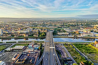
The city of Glasgow, Scotland, has a transport system encompassing air, rail, road and an underground light metro line. Prior to 1962, the city was also served by trams. Commuters travelling into Glasgow from the neighbouring local authorities of North and South Lanarkshire, Renfrewshire, East Renfrewshire, and East and West Dunbartonshire have a major influence on travel patterns, with tens of thousands of residents commuting into the city each day. The most popular mode of transport in the city is the car, used by two-thirds of people for journeys around the city.

Leicester City Centre is Leicester's historical commercial, cultural and transport hub and is home to its central business district. Its inner core is roughly delineated by the A594, Leicester's inner ring road, although the various central campuses of the University of Leicester, De Monfort University and Leicester College are adjacent to the inner ring road and could be considered to be a continuation of the City centre. In a similar way, the Leicester Royal Infirmary precinct, the New Walk business district (Southfields), the Welford Road Stadium of Leicester Tigers' RUFC and the King Power Stadium of Leicester City to the south, and the Golden Mile to the north could also be deemed to be extensions to the central core.

The A594 Central Ring is the name of Leicester's central distributor road network.

Queensway is the name of a number of roads in central Birmingham, England. The name most often refers to the Queensway tunnel, part of the A38. However the name is also used as a suffix of several other roads and circuses, such as Smallbrook Queensway and Colmore Circus Queensway; all of these were once part of the historic A4400 Inner Ring Road, which was often called collectively the Queensway.
The A56 is a road in England which extends between the city of Chester in Cheshire and the village of Broughton in North Yorkshire. The road contains a mixture of single and dual carriageway sections, and traverses environments as diverse as the dense urban sprawl of inner city Manchester and the lightly populated region of rural east Lancashire. The road includes a short section of trunk road between the end of the M66 motorway near Ramsbottom and the M65 motorway west of Burnley.
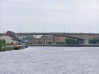
The Glasgow Inner Ring Road was a proposed ring road encircling the city centre of Glasgow, Scotland. Construction of the roads began in 1965, and half of its circumference was completed by 1972, but no subsequent construction was made and the remaining plans were formally abandoned in 1980. After 30 years, a route following roughly the southern section of the proposals have also been created as the new M74.
The Los Alamitos Traffic Circle, informally known as the Long Beach Traffic Circle, is a roundabout at the intersection of Lakewood Boulevard, Pacific Coast Highway and Los Coyotes Diagonal in Long Beach, California. The intersection was originally constructed as a traffic circle in 1930 and reconstructed as a modern roundabout in 1993.

The R136 road is a regional road in Ireland, located in the southwest of Dublin. Named the Outer Ring Road, the route, which is dual carriageway, runs from the N4 at Lucan to the N81 at Tallaght, bypassing west of Clondalkin and crossing the N7 near Citywest. It was built as part of the planning for the new town of Adamstown.

Chester city walls consist of a defensive structure built to protect the city of Chester in Cheshire, England. Their construction was started by the Romans when they established the fortress of Deva Victrix between 70 and 80 [CE]. It originated with a rampart of earth and turf surmounted by a wooden palisade. From about 100 CE they were reconstructed using sandstone, but were not completed until over 100 years later. Following the Roman occupation nothing is known about the condition of the walls until Æthelflæd refounded Chester as a burgh in 907. The defences were improved, although the precise nature of the improvement is not known. After the Norman conquest, the walls were extended to the west and the south to form a complete circuit of the medieval city. The circuit was probably complete by the middle of the 12th century.

The A40 is a major trunk road connecting London to Fishguard, Wales. The A40 in London starts in the City of London and passes through six London Boroughs: Camden, Westminster, Kensington & Chelsea, Hammersmith & Fulham, Ealing and Hillingdon, to meet the M40 motorway junction 1 at Denham, Buckinghamshire.
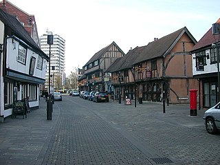
Spon Street is an historic street in central Coventry, in the West Midlands of England. The street was once part of a route that ran from Gosford to Birmingham – a route which remained intact until the 1960s. During the construction of Coventry's Inner Ring Road, built to relieve traffic on the narrow city centre streets, Spon Street was cut in half and the route severed.

Road building was central to planning policy for much of the 20th century in Bristol, England. The planned road network evolved over time but at its core was a network of concentric ring roads and high-capacity radial roads.