
The M11 is a 55 miles (89 km) motorway that runs north from the North Circular Road (A406) in South Woodford to the A14, northwest of Cambridge, England. Originally proposed as a trunk road as early as 1915, various plans were considered throughout the 1960s, with final construction being undertaken between 1975 and 1980. The motorway was opened in stages, with the first stage between junctions 7 and 8 opening in June 1975, and the completed motorway becoming fully operational in February 1980. Running from Woodford to Girton, the motorway provides direct access to Harlow, Cambridge and since 2002, greatly improved access to London Stansted Airport.

The A12 is a major road in Eastern England. It runs north-east/south-west between London and the coastal town of Lowestoft in the north-eastern corner of Suffolk, following a similar route to the Great Eastern Main Line until Ipswich. A section of the road between Lowestoft and Great Yarmouth became part of the A47 in 2017. Between the junctions with the M25 and the A14, the A12 forms part of the unsigned Euroroute E30. Unlike most A roads, this section of the A12, together with the A14 and the A55, has junction numbers as if it were a motorway.
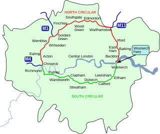
The North Circular Road is a 25.7-mile-long (41.4 km) ring road around Central London in England. It runs from Chiswick in the west to Woolwich in the east via suburban North London, connecting various suburbs and other trunk roads in the region. Together with its counterpart, the South Circular Road, it forms a ring road around central London. This ring road does not make a complete circuit of the city, being C-shaped rather than a complete loop as the crossing of the River Thames in the east is made on the Woolwich Ferry.
The A10 is a major road in England which runs between The City of London and King's Lynn in Norfolk.
The A11 is a major trunk road in England. It originally ran roughly north east from London to Norwich, Norfolk. It now consists of a short section in Inner London and a much longer section in Cambridgeshire, Suffolk and Norfolk. The lengthy section between these was renumbered as a result of the opening of the M11 in the 1970s and then the A12 extension in 1999.

Roy Chadwick, CBE, FRSA, FRAeS was an aircraft design engineer for the Avro Company.

Poynton is a town in the civil parish of Poynton-with-Worth, in the Cheshire East district, in the ceremonial county of Cheshire, England, on the easternmost fringe of the Cheshire Plain, 11 miles (18 km) south-east of Manchester, 7 miles (11 km) north of Macclesfield and 5 miles (8 km) south of Stockport. From 1974 to 2009 it was in Macclesfield district.

The A53 is a primary route in the English Midlands, that runs from Buxton in Derbyshire to Shrewsbury in Shropshire.

Illinois Route 116 is a 176.07-mile-long (283.36 km) cross-state rural state highway that runs from U.S. Route 34 by Gladstone east to the intersection of US 45 and Old US 45, on the north side of Ashkum.

The A16 road is a principal road of Lincolnshire in the East Midlands region of England, connecting the port of Grimsby and Peterborough, where it meets the A1175, A47 & A1139 then on to the A1 and the A605; the latter, in turn, giving a through route to Northampton and the west, and south west of England. Its length is 78 miles (126 km). The road was "de-trunked", with responsibility largely returned to Lincolnshire County Council from the Highways Agency in 2002.

Woodford is a suburban village in the Metropolitan Borough of Stockport, Greater Manchester, England, 5.2 miles (8.4 km) south of Stockport, 5.7 miles (9.2 km) north-west of Macclesfield and 10.7 miles (17.2 km) south-east of Manchester. Woodford is the most southerly point of Greater Manchester; it consists of a ribbon of properties and a housing development along the A5102 road, around which is open countryside.

The Martha Layne Collins Blue Grass Parkway is a controlled-access highway running from Elizabethtown, Kentucky to Woodford County, Kentucky, for a length of 71.134 miles (114.479 km). It intersects with Interstate 65 at its western terminus, and U.S. Route 60 at its eastern terminus. It is one of seven highways that are part of the Kentucky parkway system. The road is designated unsigned Kentucky Route 9002. It is constructed similar to the Interstate Highway system, though sections do not measure up to current Interstate standards.

State Route 88 is a 7.868-mile (12.662 km) north–south state highway in the Carson Valley in western Douglas County, Nevada, United States. It runs from the California state line along Woodfords Road to U.S. Route 395 in Minden. Prior to 1957, the highway existed as State Route 37.
State Highway 170 (SH 170), also known as the Alliance Gateway Freeway, is a Texas state highway in the northern suburbs of Fort Worth in the Alliance area. The highway was designated in 1988.

Cheshire East is a unitary authority area with borough status in Cheshire, England. The local authority is Cheshire East Council. Towns within the area include Crewe, Macclesfield, Congleton, Sandbach, Wilmslow, Handforth, Knutsford, Poynton, Bollington, Alsager and Nantwich. The council is based in the town of Sandbach.

Kentucky Route 33 is a 32.094-mile-long (51.650 km), two-lane, north–south state highway in Kentucky managed by the Kentucky Transportation Cabinet.

U.S. Route 67 is a U.S. highway running from Presidio, Texas northeast to Sabula, Iowa. In the U.S. state of Arkansas, the route runs 279.15 miles (449.25 km) from the Texas border in Texarkana northeast to the Missouri border near Corning. The route passes through several cities and towns, including Hope, Benton, Little Rock, Jacksonville, Cabot, Beebe, Walnut Ridge, and Pocahontas.

The A555 road is in Greater Manchester, England, along its southern border with Cheshire. It is officially known as the Manchester Airport Eastern Link and runs between Manchester Airport and the A6 south of Hazel Grove in the borough of Stockport.

Interstate 2 (I-2) is a partially completed Interstate Highway running through the Lower Rio Grande Valley of South Texas. It begins at the intersection of US Highway 83 (US 83) and Business US 83 in Peñitas and heads eastward before terminating at I-69E/US 77/US 83 in Harlingen. A westward extension around La Joya has been partially completed, but not yet part of I-2. For almost its entire length, I-2 runs concurrently with US 83. I-2 also parallels Mexican Federal Highway 2 (Fed. 2), another major east–west route that traces the Mexico–US border along the Mexican side of the Rio Grande. When completed, the western terminus will be the city of Laredo. The route is one of the more recently designated Interstate Highways; it was signed as an Interstate in 2013. Its construction is part of an expansion of the Interstate System into southern Texas that includes the three branches of I-69. It currently intersects I-69E and I-69C and will, when completed to Laredo, terminate I-69W as well. This complex of Interstate Highways does not yet connect to the rest of the system.
