Audlem is a village and civil parish located in Cheshire, North West England. In 2021, it had a population of 1,832.

The A41 is a trunk road between London and Birkenhead, England. Now in parts replaced by motorways, it passes through or near Watford, Kings Langley, Hemel Hempstead, Aylesbury, Bicester, Solihull, Birmingham, West Bromwich, Wolverhampton, Newport, Whitchurch, Chester and Ellesmere Port.

The M40 motorway links London, Oxford, and Birmingham in England, a distance of approximately 89 miles (143 km).

The A34 is a major road in England. It runs from the A33 and M3 at Winchester in Hampshire, to the A6 and A6042 in Salford, close to Manchester City Centre. It forms a large part of the major trunk route from Southampton, via Oxford, to Birmingham, The Potteries and Manchester. For most of its length, it forms part of the former Winchester–Preston Trunk Road. Improvements to the section of road forming the Newbury Bypass around Newbury were the scene of significant direct action environmental protests in the 1990s. It is 151 miles (243 km) long.
The A483, officially described as the Swansea to Manchester Trunk Road, although now ending in Chester, is a major road in the United Kingdom. It runs from Swansea in Wales to Chester in England via Llandovery, Llandrindod Wells, Oswestry and Wrexham, a distance of around 153 miles (246 km).
The A19 is a major road in England running approximately parallel to and east of the A1 road. Although the two roads meet at the northern end of the A19, the two roads originally met at the southern end of the A19 in Doncaster, but the old route of the A1 was changed to the A638. From Sunderland northwards, the route was formerly the A108. In the past the route was known as the East of Snaith-York-Thirsk-Stockton-on-Tees-Sunderland Trunk Road. Most traffic joins the A19, heading for Teesside, from the A168 at Dishforth Interchange.

The A49 is an A road in western England, which traverses the Welsh Marches region. It runs north from Ross-on-Wye in Herefordshire via Hereford, Leominster, Ludlow, Shrewsbury and Whitchurch, then continues through central Cheshire to Warrington and Wigan before terminating at its junction with the A6 road just south of Bamber Bridge, near the junction of the M6, M65 and M61 motorways.

Woore is a village and civil parish in the north east of Shropshire, England. The population of the village as recorded in the 2011 census is 633, and for the civil parish is 1,069. The civil parish extends to about 3,950 acres.

The A500 is a major primary A road in Staffordshire and Cheshire, England. It is dual carriageway for most of its length and connects Nantwich, junctions 16 and 15 of the M6 motorway with the city of Stoke-on-Trent. It is 19 miles (31 km) long.

The A53 is a primary route in the English Midlands, that runs from Buxton in Derbyshire to Shrewsbury in Shropshire.

The A689 is a road in northern England that runs east from the A595, 3.1 miles (5.0 km) to the west of Carlisle in Cumbria, to Hartlepool in County Durham.
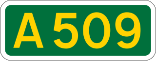
The A509 is a short A-class road for north–south journeys in south central England, forming the route from Kettering in Northamptonshire to the A5 in Milton Keynes, via M1 junction 14.

The A530 road is a road linking the A525 east of Whitchurch, Shropshire, England with the A559 east of Northwich, in Cheshire. The road follows the route:

Bwlchgwyn is a village in Wrexham County Borough, Wales, on the A525 road, 5 miles (8 km) west of the city of Wrexham and 10 miles (16 km) south-east of the town of Ruthin. Bwlchgwyn is part of the community of Brymbo. In the 2011 Census the population of the village was 855.

The A498 is a 16-mile road between Pen-y-Gwryd and Porthmadog in North Wales.
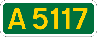
The A5117 is a road in Cheshire, England. It runs between Shotwick (53.2374°N 2.9875°W) and Helsby (53.2613°N 2.7814°W) and connects the A550 at Woodbank to the M56. As such it forms a northerly bypass to Chester and a shorter route between the North West and North Wales than the A55.

The A146 is an A road that connects Norwich in Norfolk and Lowestoft in Suffolk, two of East Anglia's largest population centres. It is around 27 miles (43 km) in length and has primary classification along its entire route. It is mainly single carriageway throughout its route, with the exception of a section of dual carriageway on the southern edge of Norwich.

The A405 is a 4.8 miles dual carriageway road in Hertfordshire, England, from the A41 at Leavesden Green, near Watford, to the A414 at Park Street Roundabout near St Albans.

The A158 road is a major route that heads from Lincoln in the west to Skegness on the east coast. The road is located entirely in the county of Lincolnshire and is single carriageway for almost its entirety. The road is approximately 40 miles (64 km) long. The road gets quite congested with holiday traffic during the summer.
The A25 is the name given to the sections of the main route connecting Strangford with Castleblayney that lie in Northern Ireland. It is a road of regional importance, serving much of south Armagh and south Down. The road commences in the village of Strangford, on the shores of Strangford Lough, from which the Portaferry - Strangford Ferry service transports vehicles to Portaferry on the Ards peninsula. The entirety of the route is 61.2 miles, of which 54.5 miles are located north of the border, forming the A25 - the remaining 6.7 miles form the R182 in the Republic of Ireland.

