Marchwiel

Last updated

Marchwiel
  • Welsh: Marchwiail or Marchwiel
Marchwiel Parish Church - geograph.org.uk - 65687.jpg
Marchwiel Parish Church
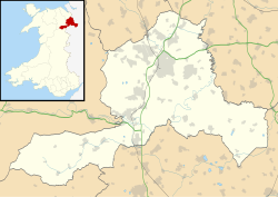
Wrexham UK location map.svg
Red pog.svg
Marchwiel
Location within Wrexham
Population1,379 (2011)
OS grid reference SJ356476
Community
  • Marchwiel
Principal area
Country Wales
Sovereign state United Kingdom
Post town WREXHAM
Postcode district LL13
Dialling code 01978
Police North Wales
Fire North Wales
Ambulance Welsh
UK Parliament
Senedd Cymru – Welsh Parliament
List of places
UK
Wales
Wrexham

53°01′19″N2°57′32″W / 53.022°N 2.959°W / 53.022; -2.959

Contents

Wales Wrexham Community Marchwiel map.svg
Map of the community

Marchwiel (Welsh : Marchwiail; standardised: Marchwiel [1] ) is a village and community in Wrexham County Borough, Wales.

It is about 2 miles south-east of Wrexham city on the A525 road towards Bangor-on-Dee. The community has an area of 1,488 hectares and a population of 1,418 (2001 census), the population falling to 1,379 at the 2011 Census. [2]

There are several large country houses in the area including Marchwiel Hall, Bryn-y-grog, Old Sontley and Erddig Hall, now a National Trust property and a popular tourist attraction. The churchyard is the resting place of the penultimate owner of Erddig, Simon Yorke (1903-1966). The 19th century, Marchwiel Hall was acquired by Sir Alfred McAlpine, founder of Alfred McAlpine and son of 'Concrete' Bob McAlpine. [3]

In the Middle Ages there was a church at Marchwiel dedicated to Saint Deiniol. It was recorded in early times as Plwyf y Marchwiail, "the parish of the saplings"; [4] this is sometimes taken to refer to the materials used to build the first church. The current church building dates from 1778 and is dedicated to Saint Marcella. The church contains a number of memorials to members of the Yorke family of Erddig and has a stained-glass window showing the Yorke family tree. The public house is the Red Lion which dates back to the early 1900s and is said to be the centre of the village.

Marchwiel had a station on the Wrexham and Ellesmere Railway. The station closed in 1962, when the Wrexham and Ellesmere Railway closed to passengers. [5]
Governance

An electoral ward in the same name exists. This ward includes Erbistock and at the 2011 census had a total population of 2,371. [6]

Related Research Articles

<span class="mw-page-title-main">Wrexham</span> City in north-east Wales

Wrexham is a city and the administrative centre of Wrexham County Borough in Wales. It is located between the Welsh mountains and the lower Dee Valley, near the border with Cheshire in England. Historically in the county of Denbighshire, and later the county of Clwyd in 1974, it has been the principal settlement of Wrexham County Borough since 1996.

<span class="mw-page-title-main">Bangor-on-Dee</span> Village in Wales

Bangor-on-Dee is a village and community in Wrexham County Borough, Wales, on the banks of the River Dee. Until 1974 it was in the exclave of Flintshire known as the Maelor Saesneg, and from 1974 to 1996 in the county of Clwyd.

<span class="mw-page-title-main">Chirk</span> Town in Wales

Chirk is a town and community in Wrexham County Borough, Wales, 10 miles south of Wrexham, between it and Oswestry. At the 2011 census, it had a population of 4,468. Historically in the traditional county of Denbighshire, and later Clwyd, it has been part of Wrexham County Borough since a local government reorganisation in 1996. The border with the English county of Shropshire is immediately south of the town, on the other side of the River Ceiriog.

<span class="mw-page-title-main">Wrexham County Borough</span> County borough in Wales

Wrexham County Borough is a county borough, with city status, in the north-east of Wales. It borders the English ceremonial counties of Cheshire and Shropshire to the east and south-east respectively along the England–Wales border, Powys to the south-west, Denbighshire to the west and Flintshire to the north-west. The city of Wrexham is the administrative centre. The county borough is part of the preserved county of Clwyd.

<span class="mw-page-title-main">Deiniol</span> Welsh saint, first bishop of Bangor

Saint Deiniol was traditionally the first Bishop of Bangor in the Kingdom of Gwynedd, Wales. The present Bangor Cathedral, dedicated to Deiniol, is said to be on the site where his monastery stood. He is venerated in Brittany as Saint Denoual. In English and Latin his name is sometimes rendered as Daniel.

<span class="mw-page-title-main">Erddig</span> Country house and estate in Wrexham, North Wales

Erddig is a country house and estate in the community of Marchwiel, approximately 2 miles (3.2 km) south of Wrexham, Wales. It is centred on a country house which dates principally from between 1684 and 1687, when the central block was built by Joshua Edisbury, and the 1720s, when the flanking wings were added by its second owner, John Meller. Erddig was inherited by Simon Yorke in 1733, and remained in the Yorke family until it was given to the National Trust by Philip Yorke III in 1973.

<span class="mw-page-title-main">Minera</span> Village in Wales

Minera is a village and community in Wrexham County Borough, Wales. It adjoins the village of Coedpoeth.

<span class="mw-page-title-main">Llanuwchllyn</span> Human settlement in Wales

Llanuwchllyn is a village and community in Gwynedd, Wales, near the southern end of Bala Lake. It is one of the most sparsely populated communities in Wales.

<span class="mw-page-title-main">Gwersyllt</span> Village in Wales

Gwersyllt is an urban village and community in Wrexham County Borough, Wales.

<span class="mw-page-title-main">Penley</span> Village in Wales

Penley is a village in the County Borough of Wrexham, in Wales close to the border with Shropshire, England, and had a population of 606 as of the 2011 census.

<span class="mw-page-title-main">Garden Village, Wrexham</span> Suburb and ward of Wrexham, Wales

Garden Village is a suburb of the city of Wrexham and an electoral division (ward) in the community of Rhosddu in Wrexham County Borough, Wales. The population of the ward at the 2011 census was 2,035 It lies to the west of Chester Road and borders the wards of Stansty to the south and east, Gwersyllt East and South to the north west, Little Acton and Acton to the west, and a small section of Gresford to the north.

<span class="mw-page-title-main">Rhostyllen</span> Village in Wrexham County Borough, Wales

Rhostyllen is a village in Wrexham County Borough, Wales, south-west of the city of Wrexham. At the time of the 2001 census, area Wrexham 014A, which includes Rhostyllen itself, had a population of 1,383 in 599 households.

<span class="mw-page-title-main">Willington Worthenbury</span> Community in Wrexham County Borough, Wales

Willington Worthenbury is a community in Wrexham County Borough, Wales, and is situated near the England–Wales border.

<span class="mw-page-title-main">Tanyfron</span> Village in Wrexham County Borough, Wales

Tanyfron is a village in Wrexham County Borough in Wales. At the time of the 2001 census, the population of area Wrexham 006A, which includes Tanyfron and a number of other small settlements, was 1,347. The village is part of the local government Community of Brymbo and is in the Vron electoral ward. The built-up area had a population of well over 2,000 as of the 2011 census.

<span class="mw-page-title-main">Esclusham</span> Community in Wrexham County Borough, Wales

Esclusham is a community and electoral ward in Wrexham County Borough, Wales.

<span class="mw-page-title-main">Sesswick</span> Community in Wrexham County Borough, Wales

Sesswick is a community in Wrexham County Borough, Wales. It lies south-east of Wrexham near Marchwiel. The population of the community at the 2011 Census was 609.

Philip Yorke was a Welsh politician who sat in the House of Commons between 1775 and 1792 and an antiquary who developed an interest in Welsh history and genealogy relatively late in life. He was the author of The Royal Tribes of Wales (1799).

<span class="mw-page-title-main">Offa, Wrexham</span> Community in Wrexham County Borough, Wales

Offa is a community and electoral ward in Wrexham County Borough, Wales, covering most of the south-western portion of the city of Wrexham. It is bordered by the communities of; Rhosddu, and Caia Park to the north, Abenbury to the east, Esclusham, and Marchwiel to the south, and Broughton, Coedpoeth, and Gwersyllt to the west.

Marchwiel Hall is a Grade II listed building in the village of Marchwiel, Wrexham County Borough in North Wales.

References

  1. The Welsh Language Commissioner recommends "Marchwiel" is to be used in Welsh, just as in English. "Standardised Welsh Place names". www.welshlanguagecommissioner.wales. Retrieved 29 March 2023.
  2. "Community population 2011" . Retrieved 19 November 2015.
  3. Historic Marchwiel Hall on the market for £2.5 million, 9 July 2010 BBC North West
  4. Archaeologia Cambrensis, 1917, 308
  5. "Wrexham and Ellesmere Railway". Archived from the original on 16 April 2019.{{cite web}}: CS1 maint: unfit URL (link)
  6. "Ward population 2011". Archived from the original on 20 November 2015. Retrieved 19 November 2015.