Pentre Maelor

Last updated

Pentre Maelor
Village
Housing at Pentre Maelor (geograph 7100543).jpg
Housing of the estate along Bridge Road South
Wrexham UK location map.svg
Red pog.svg
Pentre Maelor
Location within Wrexham
Area0.3375 km2 (0.1303 sq mi)
Population305 (2011 census) [1]
  Density 904/km2 (2,340/sq mi)
OS grid reference SJ 3735 4888
Community
Principal area
Preserved county
Country Wales
Sovereign state United Kingdom
Post town WREXHAM
Postcode district LL13
Dialling code 01978
Police North Wales
Fire North Wales
Ambulance Welsh
UK Parliament
Senedd Cymru – Welsh Parliament
List of places
UK
Wales
Wrexham
53°02′01″N2°56′08″W / 53.033578°N 2.935621°W / 53.033578; -2.935621

Pentre Maelor is a housing estate near Wrexham Industrial Estate in Wrexham County Borough, Wales. In the 2011 census, its built-up area had a population of 305. [1]

The village is part of the community of Abenbury, and forms the majority of the community's population. The River Clywedog flows just south of the village. Pentre Maelor was established in 1947 as a housing estate to provide accommodation for workers from factories in the area. [2] The village has retained its original layout, which consists of a rectangular central lock and connected 'wings' of houses, each of which is built around a green space. [3] One of those green spaces located in the centre of the estate, is an Owain Glyndwr Field protected by Fields in Trust, and operated by Wrexham County Borough Council. [4]

History

The housing estate was originally known as "Pilgrim's Place", as the area served as a burial place for non-conformists who were not allowed a burial at Wrexham Cemetery. The first non-conformist to be buried was J Lloyd of Bryn Agog Hall of which the area surrounding his grave was given the name. [5]

During World War II, the UK Government built a Royal Ordnance Factory in the area, producing cordite, for use in firing shells. Following the war, the area was developed into a trading estate when the land came under the ownership of the Board of Trade. The first factories on the estate, were built for Courtaulds, Johnson & Johnson and British Tissue. Pentre Maelor was developed as a housing estate to accommodate these factory workers. The housing estate was built in 1947 by Edward Gittings and the first residents moved in by 1948. [5]

HM Prison Berwyn was built in 2017, to a short distance north-east of the housing estate. [6] Prior to its eventual construction, residents of the estate were consulted on the proposals. [7]

Related Research Articles

<span class="mw-page-title-main">Wrexham</span> City in north-east Wales

Wrexham is a city and the administrative centre of Wrexham County Borough in Wales. It is located between the Welsh mountains and the lower Dee Valley, near the border with Cheshire in England. Historically in the county of Denbighshire, and later the county of Clwyd in 1974, it has been the principal settlement of Wrexham County Borough since 1996.

<span class="mw-page-title-main">Denbighshire (historic)</span> Historic county in Wales

Until 1974, Denbighshire, or the County of Denbigh, was an administrative county in the north of Wales, later classed as one of the thirteen historic counties of Wales. It was a maritime county, that was bounded to the north by the Irish Sea, to the east by Flintshire, Cheshire and Shropshire, to the south by Montgomeryshire and Merionethshire, and to the west by Caernarfonshire.

<span class="mw-page-title-main">David Hanmer</span>

Sir David Hanmer, KS, SL (c.1332–1387) was a fourteenth century Anglo-Welsh Justice of the King's Bench from Hanmer, Wales, best known as Owain Glyndŵr's father-in-law and the father of Glyndŵr's chief supporters.

<span class="mw-page-title-main">Wrexham County Borough</span> County borough in Wales

Wrexham County Borough is a county borough, with city status, in the north-east of Wales. It borders the English ceremonial counties of Cheshire and Shropshire to the east and south-east respectively, Powys to the south-west, Denbighshire to the west and Flintshire to the north-west. The city of Wrexham is the administrative centre. The county borough is part of the preserved county of Clwyd.

<span class="mw-page-title-main">Wrexham Maelor</span> Former district of Clwyd, Wales

Wrexham Maelor was a local government district with borough status, being one of six districts in the county of Clwyd, north-east Wales, from 1974 to 1996.

<span class="mw-page-title-main">Glyndŵr</span> Former district of Clwyd, Wales

Glyndŵr was one of six local government districts in the county of Clwyd in Wales from 1974 to 1996.

<span class="mw-page-title-main">Acton, Wrexham</span> Community in Wrexham County Borough, Wales

Acton is a suburb and community in Wrexham, Wrexham County Borough, Wales. It spans the north-eastern part of Wrexham. The area is largely residential and at its centre, lies Acton Park, the location of the former Acton Hall.

<span class="mw-page-title-main">Abenbury</span> Community in Wrexham County Borough, Wales

Abenbury is a community in Wrexham County Borough, Wales. It is situated south-east of Wrexham city and includes the village of Pentre Maelor and part of the Wrexham Industrial Estate.

<span class="mw-page-title-main">Wrexham Industrial Estate</span> Industrial area in Wrexham County Borough, Wales

Wrexham Industrial Estate is a well defined industrial area in Wrexham. It is sited on the eastern outskirts of the city and 3 miles from the centre of Wrexham.

<span class="mw-page-title-main">Brymbo</span> Village in Wales

Brymbo is a village and community in Wrexham County Borough, Wales. It lies in the hilly country to the west of Wrexham city, largely surrounded by farmland.

<span class="mw-page-title-main">Pentre Bychan</span> Hamlet in Wrexham County Borough, Wales

Pentre Bychan is a semi-rural hamlet in Wrexham County Borough, Wales.

<span class="mw-page-title-main">Gwersyllt</span> Village in Wales

Gwersyllt is an urban village and community in Wrexham County Borough, Wales.

<span class="mw-page-title-main">Wrexham County Borough Council</span> Local government authority in north-east Wales

Wrexham County Borough Council is the governing body for Wrexham County Borough, a principal area with city status in north Wales, covering Wrexham and the surrounding area.

<span class="mw-page-title-main">Rhosddu</span> Community in Wrexham County Borough, Wales

Rhosddu is a suburb and community in Wrexham County Borough, Wales, covering the north-western parts of the city of Wrexham and comprises the wards of Grosvenor, Garden Village and Stansty.

<span class="mw-page-title-main">Garden Village, Wrexham</span> Suburb and ward of Wrexham, Wales

Garden Village is a suburb of the city of Wrexham and an electoral division (ward) in the community of Rhosddu in Wrexham County Borough, Wales. The population of the ward at the 2011 census was 2,035 It lies to the west of Chester Road and borders the wards of Stansty to the south and east, Gwersyllt East and South to the north west, Little Acton and Acton to the west, and a small section of Gresford to the north.

<span class="mw-page-title-main">Plas Coch</span> Area of Wrexham

Plas Coch is an area of the community of Rhosddu, in the city of Wrexham, Wales. A major retail and educational area of Wrexham, it lies to the north-west of Wrexham city centre. Formerly known as Lower Stansty, the term has fallen out of use in preference for Plas Coch in recent years, likely due to the popular retail area which shares its name.

<span class="mw-page-title-main">History of Wrexham</span> Aspect of history

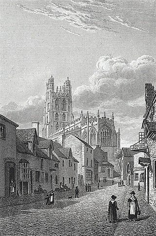
The city of Wrexham in north-east Wales has a history dating back to ancient times. The former market town was the site of heavy industry in the 19th and 20th centuries, and is now an active commercial centre. Wrexham was granted city status in 2022.

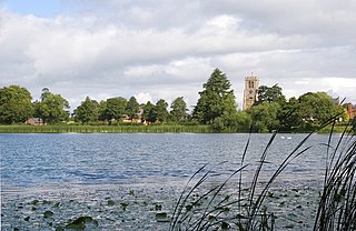
The city of Wrexham has two main city parks, these being Bellevue Park and Acton Park. On the outskirts of the city there is also open parkland on and surrounding the Erddig estate. There is also a city centre green and various smaller parks and open spaces.

<span class="mw-page-title-main">Offa, Wrexham</span> Community in Wrexham County Borough, Wales

Offa is a community and electoral ward in Wrexham County Borough, Wales, covering most of the south-western portion of the city of Wrexham. It is bordered by the communities of; Rhosddu, and Caia Park to the north, Abenbury to the east, Esclusham, and Marchwiel to the south, and Broughton, Coedpoeth, and Gwersyllt to the west.

References

  1. 1 2 Under the dataset as "Pentre Maelor" in "Best fit of Lower Super Output Areas to built up areas: 2011". GOV.WALES. 20 May 2015. Retrieved 19 July 2023.
  2. "About – Abenbury Community Council". Archived from the original on 3 July 2022. Retrieved 3 July 2022.
  3. "Pentre Maelor Housing Estate, Wrexham (409234)". Coflein. RCAHMW . Retrieved 3 July 2022.
  4. "Owain Glyndwr Field (Pentre Maelor)". Fields in Trust. Archived from the original on 3 July 2022. Retrieved 3 July 2022.
  5. 1 2 "Pentre Maelor – A Brief History". Abenbury Community Council. Archived from the original on 29 January 2022. Retrieved 3 July 2022.
  6. "Wrexham's New Prison HMP Berwyn Opens". Wrexham.com. Archived from the original on 26 April 2022. Retrieved 3 July 2022.
  7. "Open meeting in Pentre Maelor over super prison site". BBC News. 19 September 2013. Archived from the original on 3 July 2022. Retrieved 3 July 2022.