
Flintshire is a county in the north-east of Wales. It borders England to the east, Denbighshire to the west and Wrexham County Borough to the south. It is named after the historic county of the same name which has notably different borders. Flintshire is considered part of the Welsh Marches and formed part of the historic Earldom of Chester and Flint. The county is governed by Flintshire County Council which has its main offices in County Hall, Mold.
Flintshire, also known as the County of Flint, is one of Wales' thirteen historic counties, and a former administrative county. It mostly lies on the north-east coast of Wales.
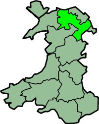
Historic Denbighshire is one of thirteen traditional counties in Wales, a vice-county and a former administrative county, which covers an area in north east Wales. It is a maritime county, bounded to the north by the Irish Sea, to the east by Flintshire, Cheshire and Shropshire, to the south by Montgomeryshire and Merionethshire, and to the west by Caernarfonshire.

The River Dee is a river in the United Kingdom. It flows through parts of both Wales and England, forming part of the border between the two countries.
The Maelor is an area of north-east Wales along the border with England. It is now entirely part of Wrexham County Borough.

English Maelor comprises one half of the Maelor region on the Welsh side of the Wales-England border, being the area of the Maelor east of the River Dee. The region has changed counties several times, previously being part of Cheshire and later a detached portion of Flintshire. The area is currently in Wales, despite its name, and administered as part of Wrexham County Borough.

Wrexham County Borough is a county borough in the north-east of Wales. It borders England to the east and south-east, Powys to the south-west, Denbighshire to the west and Flintshire to the north-west. The county borough has a population of over 135,000 inhabitants, with around 65,000 residing in either the town of Wrexham, the surrounding conurbation of urban villages around Wrexham, or the two other towns in the county borough, Chirk and Holt. The remainder lives to the south and east of Wrexham in more rural areas, including the county borough's large salient into the Ceiriog Valley, and the English Maelor.

Overton or Overton-on-Dee is a village and community in Wrexham County Borough, Wales. It is situated close to the Welsh-English border on the edge of an escarpment that winds its way around the course of the River Dee, from which Overton-on-Dee derives its name.
Maelor was a rural district in the administrative county of Flintshire, Wales, from 1894 to 1974. The area approximated to the hundred of Maelor or English Maelor, and was notable for forming a detached part of the county, surrounded by Cheshire, Denbighshire and Shropshire. The administrative centre was located at Overton.

Erbistock is a village and community in Wrexham County Borough, Wales. The village lies on the banks of the River Dee.
Maelor Way is a key long distance footpath, running 38 kilometres / 24 miles from the Offa's Dyke Path National Trail at Bronygarth to the Shropshire Way, Sandstone Trail, Llangollen Canal, South Cheshire Way, and the Marches Way all at Grindley Brook near Whitchurch.

Penley is a village in the County Borough of Wrexham, in Wales close to the border with Shropshire, England, and had a population of 606 as of the 2011 census.

The Marches Way is a partially waymarked long-distance footpath in the United Kingdom. It runs for 351 kilometres (218 mi) through the Welsh–English borderlands, traditionally known as the Welsh Marches, and links the cities of Chester in the north and Cardiff in the south.

Bronington is a village and community in Wrexham County Borough, Wales, forming a large part of the Maelor Saesneg. Historically part of Flintshire, the community has an area of 3,482 hectares and a population of 1,228, increasing to 1,242 at the 2011 Census.
Willington Worthenbury is a community in Wrexham County Borough, Wales, and is situated near the England–Wales border.

The England–Wales border, sometimes referred to as the Wales–England border or the Anglo–Welsh border, runs for 160 miles (260 km) from the Dee estuary, in the north, to the Severn estuary in the south, separating England and Wales.

The River Eitha is a small river in Wrexham County Borough, Wales. It is part of the River Dee catchment. Its name was probably derived from the Welsh word eithaf - "extremity", "farthest".
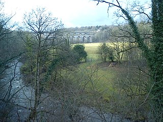
The River Ceiriog is an 18 miles (29 km) long river in north east Wales, whose name may derive from a term meaning "favoured one". It is a tributary of the River Dee. It rises at an altitude of around 1,800 ft (549 m) on the south east slopes of Moel Fferna in the Berwyn Mountains, and flows through the Ceiriog Valley in Wrexham County Borough. It flows below Chirk Castle and the town of Chirk, where the Chirk Aqueduct carries the Llangollen Canal over the river. The Ceiriog joins the Dee east of the town. In its lower reaches the river forms the border between Wales and Shropshire in England. Home to a Trout fishing club, the river and its valley were described by British prime minister David Lloyd George as "a little bit of heaven on earth". As well as being a home to trout the first grayling to be artificially reared in Wales were released into the river in 2009.

Whitewell is a small dispersed rural settlement, and surrounding ecclesiastical parish, in the east of Wrexham County Borough, Wales.


