Bronington

Last updated

Bronington
Bronington Church.jpg
Holy Trinity Church
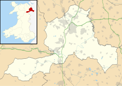
Wrexham UK location map.svg
Red pog.svg
Bronington
Location within Wrexham
Population1,242 (2011 Census)
OS grid reference SJ484395
Community
  • Bronington
Principal area
Preserved county
Country Wales
Sovereign state United Kingdom
Post town WHITCHURCH
Postcode district SY13
Dialling code 01948
Police North Wales
Fire North Wales
Ambulance Welsh
UK Parliament
Senedd Cymru – Welsh Parliament
List of places
UK
Wales
Wrexham
52°57′00″N2°46′08″W / 52.950°N 2.769°W / 52.950; -2.769

Bronington is a village and community in Wrexham County Borough, Wales, forming a large part of the Maelor Saesneg. Within the boundaries of the historic county of Flintshire, the community has an area of 3,482 hectares and a population of 1,228 (2001 Census), [1] increasing to 1,242 at the 2011 Census. [2]

Contents

The village church, Holy Trinity, was converted from a former brick tithe barn in 1836. [3] To the north-east of the village is Iscoyd Park, a stately home with surrounding parkland which was built around 1740 and enlarged in the 19th century. South of the village is Fenn's Moss, an area of peat bog stretching over into Shropshire, which was declared a national nature reserve in 1996 because of its importance for wildlife.
Governance

An electoral ward in the same name exists. This ward stretches north-west to Bangor-on-Dee with a total population at the 2011 Census of 3,179. [4]

The community itself is made up of three wards: Bronington, Iscoyd and Tybroughton.

Related Research Articles

<span class="mw-page-title-main">Wrexham</span> City in north-east Wales

Wrexham is a city and the administrative centre of Wrexham County Borough in Wales. It is located between the Welsh mountains and the lower Dee Valley, near the border with Cheshire in England. Historically in the county of Denbighshire, and later the county of Clwyd in 1974, it has been the principal settlement of Wrexham County Borough since 1996.

<span class="mw-page-title-main">Holywell, Flintshire</span> Market town and community in Wales

Holywell is a market town and community in Flintshire, Wales. It lies to the west of the estuary of the River Dee. The community includes Greenfield.

<span class="mw-page-title-main">Wrexham County Borough</span> County borough in Wales

Wrexham County Borough is a county borough, with city status, in the north-east of Wales. It borders the English ceremonial counties of Cheshire and Shropshire to the east and south-east respectively, Powys to the south-west, Denbighshire to the west and Flintshire to the north-west. The city of Wrexham is the administrative centre. The county borough is part of the preserved county of Clwyd.

<span class="mw-page-title-main">Overton-on-Dee</span> Village in Wales

Overton or Overton-on-Dee is a village and community in Wrexham County Borough, Wales. It is situated close to the Welsh-English border on the edge of an escarpment that winds its way around the course of the River Dee, from which Overton-on-Dee derives its name.

<span class="mw-page-title-main">Llysfaen</span> Village in Conwy County Borough, Wales

Llysfaen is a village and community in Conwy County Borough overlooking the north coast of Wales, and situated on the hill Mynydd Marian. For local government purposes, it is also a ward. The community includes the Peulwys estate of Old Colwyn.

<span class="mw-page-title-main">Minera</span> Village in Wales

Minera is a village and community in Wrexham County Borough, Wales. It adjoins the village of Coedpoeth.

<span class="mw-page-title-main">Penyffordd</span> Village and community in Flintshire, Wales

Penyffordd or Pen-y-ffordd is a village, community and electoral ward in Flintshire, Wales, situated to the south east of Buckley and to the west of Chester. The name is derived from the Welsh Pen Y Ffordd – roughly translated as "the highest or furthest point of the road". The resident population of Penyffordd, as measured in the 2001 Census, was 3,715, increasing to 3,874 at the 2011 census.

<span class="mw-page-title-main">Hope, Flintshire</span> Village in Flintshire, Wales

Hope is a small village and community in Flintshire, north-east Wales. The village is located approximately 3 miles / 4.5 km from the Wales-England border, on the course of the River Alyn, and less than 5 miles from Wrexham.

<span class="mw-page-title-main">Brymbo</span> Village in Wales

Brymbo is a village and community in Wrexham County Borough, Wales. It lies in the hilly country to the west of Wrexham city, largely surrounded by farmland.

<span class="mw-page-title-main">Erbistock</span> Village in Wales

Erbistock is a village and community in Wrexham County Borough, Wales. The village lies on the banks of the River Dee.

<span class="mw-page-title-main">Gwersyllt</span> Village in Wales

Gwersyllt is an urban village and community in Wrexham County Borough, Wales.

<span class="mw-page-title-main">Caerhun</span> Human settlement in Wales

Caerhun is a scattered rural community, and former civil parish, on the west bank of the River Conwy. It lies to the south of Henryd and the north of Dolgarrog, in Conwy County Borough, Wales, and includes several small villages and hamlets including Llanbedr-y-cennin, Rowen, Tal-y-bont and Ty'n-y-groes. It was formerly in the historic county of Caernarvonshire. At the 2001 census, it had a population of 1,200, increasing to 1,292 at the 2011 census. It includes a large part of the Carneddau range including the lakes of Llyn Eigiau, Llyn Dulyn and Llyn Melynllyn.

<span class="mw-page-title-main">Garden Village, Wrexham</span> Suburb and ward of Wrexham, Wales

Garden Village is a suburb of the city of Wrexham and an electoral division (ward) in the community of Rhosddu in Wrexham County Borough, Wales. The population of the ward at the 2011 census was 2,035 It lies to the west of Chester Road and borders the wards of Stansty to the south and east, Gwersyllt East and South to the north west, Little Acton and Acton to the west, and a small section of Gresford to the north.

<span class="mw-page-title-main">Llandow</span> Human settlement in Wales

Llandow is a village and community in the Vale of Glamorgan, Wales. The community population taken at the 2011 census was 726. The village is located 15 miles (24 km) south west of Cardiff. The community includes the villages of Sigingstone and Llysworney.

<span class="mw-page-title-main">Rhostyllen</span> Village in Wrexham County Borough, Wales

Rhostyllen is a village in Wrexham County Borough, Wales, south-west of the city of Wrexham. At the time of the 2001 census, area Wrexham 014A, which includes Rhostyllen itself, had a population of 1,383 in 599 households.

<span class="mw-page-title-main">Trefnant</span> Village in Denbighshire, Wales

Trefnant is a village and community in Denbighshire, Wales. It is located on the A525 road in the Vale of Clwyd, about halfway between St Asaph (Llanelwy) to the north and Denbigh to the south. At the 2001 Census, the community had a population of 1,409, increasing to 1,581 at the 2011 Census.

<span class="mw-page-title-main">Marchwiel</span> Village in Wales

Marchwiel is a village and community in Wrexham County Borough, Wales.

<span class="mw-page-title-main">Willington Worthenbury</span> Community in Wrexham County Borough, Wales

Willington Worthenbury is a community in Wrexham County Borough, Wales, and is situated near the England–Wales border.

<span class="mw-page-title-main">Borras Park</span> Suburb and electoral ward in Wrexham, Wales

Borras Park is a suburb and electoral ward in the community of Acton, Wrexham, Wrexham County Borough, Wales. The name is derived from the nearby hamlet of Borras.

<span class="mw-page-title-main">Whitewell, Wrexham</span> Rural settlement in Wales

Whitewell is a dispersed rural settlement, and surrounding ecclesiastical parish, in the community of Bronington, in the east of Wrexham County Borough, Wales.

References

Notes

  1. "2001 Census: Bronington". Office for National Statistics. Archived from the original on 26 May 2011. Retrieved 19 October 2008.
  2. "community population 2011" . Retrieved 17 November 2015.
  3. "Holy Trinity Church". Wrexham County Borough Council. Archived from the original on 26 May 2011. Retrieved 2 June 2008.
  4. "Ward population 2011" . Retrieved 17 November 2015.

Sources