New Brighton, Wrexham

Last updated

New Brighton
Hamlet
Wrexham UK location map.svg
Red pog.svg
New Brighton
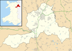
Location within Wrexham
OS grid reference SJ264513
Community
Principal area
Preserved county
Country Wales
Sovereign state United Kingdom
Post town MINERA
Postcode district LL11
Police North Wales
Fire North Wales
Ambulance Welsh
UK Parliament
Senedd Cymru – Welsh Parliament
List of places
UK
Wales
Wrexham
53°03′00″N3°05′06″W / 53.04997°N 3.08489°W / 53.04997; -3.08489

New Brighton is a small hamlet near Minera, in north-east Wales.

Background

This part of Minera parish was originally known as 'City Land', and was bequeathed by Owen Jones (died 1659), a butcher of Chester, to 'the poor of every Company of Merchants and Craftsmen in the City of Chester'. The area was steeply sloping agricultural land until the mid 18th century when a trustee of the charity, Alderman Richardson, encouraged prospecting for lead ore that was so successfully that between 1761 and 1781 some £13,000 were paid to the charity in royalties. [1]

In 1868 49 freehold building plots 'in the midst of the celebrated lead-mine district' were put up for auction by the Owen Jones' Charity at the nearby City Arms Hotel, Minera. [2] The name change to New Brighton appears to have occurred about this time as from 1869 buildings auctioned in that area began stating their location as New Brighton, Minera. [3] There were a number of public houses in the area from about 1870, including the White Lion Inn (of City Land, Minera), [4] the New Brighton Inn (also of City Land, Minera), [5] and the Rock Tavern - which was described in a dispute over renewal of its licence in 1895 as 'nothing more than a shanty on the side of the mountain, for the express purpose of catching the miners as they went home' - the licence was renewed on the basis that it was originally granted before 1869, which narrowed the options for refusing it. [6] While these appear to have closed around the time the lead mining ceased, the City Arms continued in business, providing a link to the original name of the hamlet, until it closed in 2006.

New Brighton had a Hermon Welsh Methodist Chapel (a Wesleyan chapel) which was built in 1890 of corrugated iron. [7] The building survives but is no longer used as a chapel. The Welsh Independent Chapel built nearby at The Wern in 1805 was closed in 1975 and since demolished (thought the graveyard survives). The chapel's records of deaths and baptisms survive (in the Bangor University Library) and contain the names and occupations of many from City Lands/New Brighton. [8]

These days New Brighton is a quiet residential area immediately up-slope from the car park and visitor centre for the Minera Lead Mines Country Park. [1] It has 5 listed buildings, all good examples of late 19th century workers' buildings associated with the lead mines. The former railway route that served the mines is now a footpath that links the Minera Lead Mines Country Park to Minera Limeworks.

Related Research Articles

<span class="mw-page-title-main">Tywyn</span> Small coastal town in Gwynedd, Wales

Tywyn, formerly spelled Towyn, is a town, community, and seaside resort on the Cardigan Bay coast of southern Gwynedd, Wales. It was previously in the historic county of Merionethshire. It is famous as the location of the Cadfan Stone, a stone cross with the earliest known example of written Welsh, and the home of the Talyllyn Railway.

<span class="mw-page-title-main">Rhosllanerchrugog</span> Village in Wales

Rhosllanerchrugog is a village and community in Wrexham County Borough, Wales. It lies within the historic county of Denbighshire. The entire built-up area including Penycae, Ruabon and Cefn Mawr had a population of 25,362.

<span class="mw-page-title-main">Crymych</span> Human settlement in Wales

Crymych is a village of around 800 inhabitants and a community in the northeast of Pembrokeshire, Wales. It is situated approximately 800 feet (240 m) above sea level at the eastern end of the Preseli Mountains, on the old Tenby to Cardigan turnpike road, now the A478.

<span class="mw-page-title-main">Coedpoeth</span> Village in Wales

Coedpoeth is a village and community in Wrexham County Borough, Wales. The built-up area with Minera had a population of 5,723 in the 2011 census.

<span class="mw-page-title-main">Gresford</span> Village in Wales

Gresford is a village and community in Wrexham County Borough, Wales.

The Wrexham and Minera Railway or Wrexham and Minera Branch was a railway line in North Wales between the city of Wrexham, the village of Brymbo where it served the Brymbo Steelworks, and the lead mines and limeworks at Minera. A further branch ran from Brymbo to Coed Talon, where it connected with lines to Mold. The system was constructed in several stages between 1844 and 1872, while the various lines making up the system closed in 1952, 1972 and 1982.

<span class="mw-page-title-main">Minera Lead Mines</span> Country park and former mine in Wrexham County Borough, Wales

The Minera Lead Mines were a mining operation and are now a country park and tourist centre in the village of Minera near Wrexham, in Wrexham County Borough, Wales.

<span class="mw-page-title-main">River Clywedog</span> River in Wales

The River Clywedog is a river in Wrexham County Borough, Wales. Its uses have been watering crops, powering industrial machinery but is now used as walking trails or geography trips. The river originates to the west of Wrexham, and joins the River Dee some four miles south east of the city.

<span class="mw-page-title-main">Minera</span> Village in Wales

Minera is a village and community in Wrexham County Borough, Wales. It adjoins the village of Coedpoeth.

<span class="mw-page-title-main">Bwlchgwyn</span> Village in Wales

Bwlchgwyn is a village in Wrexham County Borough, Wales, on the A525 road, 5 miles (8 km) west of the city of Wrexham and 10 miles (16 km) south-east of the town of Ruthin. Bwlchgwyn is part of the community of Brymbo. In the 2011 Census the population of the village was 855.

<span class="mw-page-title-main">Brymbo</span> Village in Wales

Brymbo is a village and community in Wrexham County Borough, Wales. It lies in the hilly country to the west of Wrexham city, largely surrounded by farmland.

<span class="mw-page-title-main">History of Wrexham</span> Aspect of history

The city of Wrexham in north-east Wales has a history dating back to ancient times. The former market town was the site of heavy industry in the 19th and 20th centuries, and is now an active commercial centre. Wrexham was granted city status in 2022.

<span class="mw-page-title-main">Farndon Bridge</span> Bridge between England and Wales

Farndon Bridge, also known as Holt Bridge, crosses the River Dee and the England-Wales border between the villages of Farndon, Cheshire, England and Holt, Wrexham, Wales. The bridge, which was built in the mid-14th century, is recorded in the National Heritage List for England and by Cadw as a designated Grade I listed building and scheduled monument. It is built from locally quarried red sandstone and had eight arches, of which five are over the river. On the Farndon side there is one flood arch and two flood arches are on the Holt side.

<span class="mw-page-title-main">Llanfechain</span> Village in northern Powys, Wales

Llanfechain is a village and community in Powys, Wales, on the B4393 road between Llanfyllin and Llansantffraid-ym-Mechain. Historically it belonged to Montgomeryshire. The River Cain runs through. The population of 465 at the 2011 Census was estimated at 476 in 2019.

<span class="mw-page-title-main">Tanyfron</span> Village in Wrexham County Borough, Wales

Tanyfron is a village in Wrexham County Borough in Wales. At the time of the 2001 census, the population of area Wrexham 006A, which includes Tanyfron and a number of other small settlements, was 1,347. The village is part of the local government Community of Brymbo and is in the Vron electoral ward. The built-up area had a population of well over 2,000 as of the 2011 census.

<span class="mw-page-title-main">Gwynfryn, Wrexham</span> Village in Wales

Gwynfryn is a hill-top village in the community of Minera in Wrexham County Borough, Wales. Its name, originally that of the village chapel, is formed from the Welsh words bryn, "hill", and gwyn, "white": "white hill". At the time of the 2001 census, its population combined with that of the neighbouring, larger village of Bwlchgwyn was 1,148.

<span class="mw-page-title-main">Llandecwyn</span> Human settlement in Wales

Llandecwyn is a hamlet near Penrhyndeudraeth in Gwynedd, Wales.

<span class="mw-page-title-main">Gresford Methodist Church</span> Church in Gresford, Wales

The Gresford Methodist Church, historically known as the Gresford Wesleyan Methodist Church, is a church on Chester Road in Gresford, Wrexham County Borough, Wales. The Wesleyan Methodist Church held its first service in 1879, and was built as a replacement for the Pant Methodist Chapel, located on Turnpike Lane in Gresford. It remains a place of worship.

References

  1. 1 2 "Gwylfa Cottage, New Brighton, Minera". Coflein (The online catalogue of archaeology, buildings, industrial and maritime heritage in Wales). Retrieved 3 March 2023.
  2. "Sale by Auction - Sale by Mr Richards". Wrexham Advertiser. 20 June 1868. p. 1.
  3. "Sale by Auction - Sales by Mr W Connor". Wrexham Advertiser. 5 June 1869. p. 1.
  4. "To be Let". Wrexham Advertiser. 7 October 1871. p. 4.
  5. "To Let". Wrexham Advertiser. 6 November 1875. p. 4.
  6. "Wrexham County Magistrates Court". Wrexham Advertiser. 5 October 1895. p. 6.
  7. "Hermon Welsh Methodist Chapel (Wesleyan), New Brighton, Minera". Coflein (The online catalogue of archaeology, buildings, industrial and maritime heritage in Wales). Retrieved 7 March 2023.
  8. "Wern Chapel Baptism & Burial Register. Wrexham". Scribd. Retrieved 18 June 2023.