
Llangollen is a town and community, situated on the River Dee, in Denbighshire, Wales. Its riverside location forms the edge of the Berwyn range, and the Dee Valley section of the Clwydian Range and Dee Valley Area of Outstanding Natural Beauty, with the easternmost point of the Dee Valley Way being within the town. It had a population of 3,658 at the 2011 census.

Wrexham is a city and the administrative centre of Wrexham County Borough in Wales. It is located between the Welsh mountains and the lower Dee Valley, near the border with Cheshire in England. Historically in the county of Denbighshire, and later the county of Clwyd in 1974, it has been the principal settlement of Wrexham County Borough since 1996.

Chirk is a town and community in Wrexham County Borough, Wales, 10 miles south of Wrexham, between it and Oswestry. At the 2011 census, it had a population of 4,468. Historically in the traditional county of Denbighshire, and later Clwyd, it has been part of Wrexham County Borough since a local government reorganisation in 1996. The border with the English county of Shropshire is immediately south of the town, on the other side of the River Ceiriog.

Wrexham County Borough is a county borough, with city status, in the north-east of Wales. It borders the English ceremonial counties of Cheshire and Shropshire to the east and south-east respectively, Powys to the south-west, Denbighshire to the west and Flintshire to the north-west. The city of Wrexham is the administrative centre. The county borough is part of the preserved county of Clwyd.

The Glyn Valley Tramway was a narrow gauge railway that ran through the Ceiriog Valley in north-east Wales, connecting Chirk with Glyn Ceiriog in Denbighshire. The gauge of the line was 2 feet 4+1⁄4 inches (718 mm) while it was horse-drawn, which was unofficially increased to 2 ft 4+1⁄2 in when steam locomotives were introduced. The total length of the line was 8+1⁄4 miles (13.3 km), 6+1⁄2 miles (10.5 km) of which were worked by passenger trains, the remainder serving a large granite quarry and several minor slate quarries.

The Ceiriog Valley is the valley of the River Ceiriog in north-east Wales. Its Welsh name, "Dyffryn Ceiriog", is the name of an electoral ward of Wrexham County Borough. The ward is the largest ward of the county borough by area and forms a strikingly-shaped salient of the county borough between Powys and Denbighshire.

Glyn Ceiriog is the principal settlement of the Ceiriog Valley and a community in Wrexham County Borough, north-east Wales. Glyn Ceiriog translates simply as Ceiriog Valley, though there are other villages in the valley. The village and community is technically known, in traditional Welsh naming style, as Llansantffraid Glyn Ceiriog or sometimes Llansanffraid Glyn Ceiriog, which means church of St Ffraid in the Ceiriog Valley, but it has come to be known simply as Glyn Ceiriog, or even Glyn for short. The name Llansanffraid is now more associated with other villages of the same name.
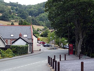
Pontfadog is a village in the Ceiriog Valley west of Chirk in Wrexham County Borough, Wales; it is part of the community of Glyntraian. Like the neighbouring village of Glyn Ceiriog, the growth of Pontfadog is connected to the area's former quarrying industry.

Llanarmon Dyffryn Ceiriog is a village in Wrexham County Borough, Wales. It lies on the River Ceiriog and is at the end of the B4500 road, five miles (8 km) south-west of Glyn Ceiriog and ten miles (16 km) north-west of Oswestry. It is within the Ceiriog Valley ward, Clwyd South Senedd constituency and Clwyd South UK parliamentary constituency. It is in the community of Ceiriog Ucha.
Ceiriog Ucha, also spelled as Ceiriog Uchaf, is a community in Wrexham County Borough, Wales. The community lies in the Ceiriog Valley and comprises the villages of Llanarmon Dyffryn Ceiriog and Tregeiriog as well as surrounding farmland and grouse and pheasant moors. It is a rural district set in low hills. The area is governed by Ceiriog Uchaf Community Council, and had a total population of 346, in 129 households, at the 2001 census. reducing to 317 in 2011.
The city of Wrexham in north-east Wales has a history dating back to ancient times. The former market town was the site of heavy industry in the 19th and 20th centuries, and is now an active commercial centre. Wrexham was granted city status in 2022.
Glyn[ˈɡlɪn] means "Valley" in Welsh and may refer to:

Pandy is a village near Gwersyllt and Rhosrobin, in Wrexham, Wrexham County Borough, Wales. The main entrance to Gresford Colliery stood in the village. Gresford Colliery Social Club is in the village and alongside it a memorial to the Gresford Disaster, which killed 266 men on September 22, 1934.
A pandy is a Welsh name for a fulling mill, and may refer to:
Glyntraian is a community in Wrexham County Borough, Wales.

Tregeiriog is a village in Wrexham County Borough, Wales. It is in the community of Ceiriog Ucha on the B4500 road between Glyn Ceiriog and Llanarmon Dyffryn Ceiriog.
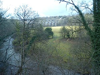
The River Ceiriog is an 18 miles (29 km) long river in north east Wales, whose name may derive from a term meaning "favoured one". It is a tributary of the River Dee. It rises at an altitude of around 1,800 ft (549 m) on the south east slopes of Moel Fferna in the Berwyn Mountains, and flows through the Ceiriog Valley in Wrexham County Borough. It flows below Chirk Castle and the town of Chirk, where the Chirk Aqueduct carries the Llangollen Canal, and the Chirk Viaduct carries the Shrewsbury–Chester line over the river. The Ceiriog joins the Dee east of the town. In its lower reaches, the river forms the border between Wales and Shropshire in England. Home to a trout fishing club, the river and its valley were described by British prime minister David Lloyd George as "a little bit of heaven on earth". As well as being a home to trout, the first grayling to be artificially reared in Wales were released into the river in 2009.

The 2022 Wrexham County Borough Council election took place on 5 May 2022 to elect 56 members to Wrexham County Borough Council, the principal council of Wrexham County Borough, Wales. On the same day, elections were held to the other 21 local authorities, and community councils in Wales as part of the 2022 Welsh local elections. The previous Wrexham County Borough all-council election took place in May 2017 and future elections will take place every five years, with the next scheduled for 2027.


