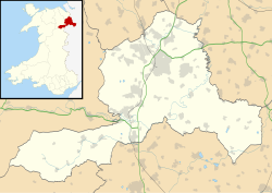
Llangollen Rural | |
---|---|
Community | |
View of the village of Froncysyllte, in Llangollen Rural | |
Location within Wrexham | |
Principal area | |
Country | Wales |
Sovereign state | United Kingdom |
Police | North Wales |
Fire | North Wales |
Ambulance | Welsh |
Llangollen Rural (Welsh : Llangollen Wledig) is a community and electoral ward in Wrexham County Borough, Wales. It contains the villages of Froncysyllte, Garth, and Trevor, and had a population of 1,999 at the 2001 census, [1] increasing to 2,059 at the 2011 Census. [2] The Pontcysyllte aqueduct is a World Heritage Site. Although named Rural, it is actually densely populated.
The area was, until 1974, the civil parish of Llangollen Rural, governed by Llangollen Rural Parish Council and located in the county of Denbighshire. [3] It became the Community of Llangollen Rural under the terms of the Local Government Act 1972, which also saw it transferred into the new county of Clwyd. When the latter was abolished in 1996, Llangollen Rural was initially included in the new county of Denbighshire, but was transferred to Wrexham County Borough following a 1998 referendum.
The community elects or co-opts 10 community councillors to Llangollen Rural Community Council, at the lowest level of local government. [4]
Denbighshire is a county in the north-east of Wales. It borders the Irish Sea to the north, Flintshire to the east, Wrexham to the southeast, Powys to the south, and Gwynedd and Conwy to the west. Rhyl is the largest town, and Ruthin is the administrative centre. Its borders differ from the historic county of the same name.
Denbighshire, or the County of Denbigh, was one of the thirteen historic counties of Wales, in the north of Wales. It was a maritime county, that was bounded to the north by the Irish Sea, to the east by Flintshire, Cheshire and Shropshire, to the south by Montgomeryshire and Merionethshire, and to the west by Caernarfonshire.
Clwyd is a preserved county of Wales, situated in the north-east corner of the country; it is named after the River Clwyd, which runs through the area. To the north lies the Irish Sea, with the English ceremonial counties of Cheshire to the east and Shropshire to the south-east. Powys and Gwynedd lie to the south and west respectively. Clwyd also shares a maritime boundary with Merseyside along the River Dee. Between 1974 and 1996, a slightly different area had a county council, with local government functions shared with six district councils. In 1996, Clwyd was abolished, and the new principal areas of Conwy County Borough, Denbighshire, Flintshire and Wrexham County Borough were created; under this reorganisation, "Clwyd" became a preserved county, with the name being retained for certain ceremonial functions.
Chirk is a town and community in Wrexham County Borough, Wales, 10 miles south of Wrexham, between it and Oswestry. At the 2011 census, it had a population of 4,468. Historically in the traditional county of Denbighshire, and later Clwyd, it has been part of Wrexham County Borough since a local government reorganisation in 1996. The border with the English county of Shropshire is immediately south of the town, on the other side of the River Ceiriog.
Wrexham County Borough is a county borough, with city status, in the north-east of Wales. It borders the English ceremonial counties of Cheshire and Shropshire to the east and south-east respectively along the England–Wales border, Powys to the south-west, Denbighshire to the west and Flintshire to the north-west. The city of Wrexham is the administrative centre. The county borough is part of the preserved county of Clwyd.
Colwyn was a local government district with borough status from 1974 to 1996, being one of six districts in the county of Clwyd, north-east Wales.
Wrexham Maelor was a local government district with borough status, being one of six districts in the county of Clwyd, north-east Wales, from 1974 to 1996.
Glyndŵr was one of six local government districts in the county of Clwyd in Wales from 1974 to 1996.
Overton or Overton-on-Dee is a village and community in Wrexham County Borough, Wales. It is situated close to the Welsh-English border on the edge of an escarpment that winds its way around the course of the River Dee, from which Overton-on-Dee derives its name.
Clwyd South was a constituency of the House of Commons of the Parliament of the United Kingdom (Westminster). The constituency was created in 1997, and it elected one Member of Parliament (MP) by the first past the post method of election.
Abenbury is a community in Wrexham County Borough, Wales. It is situated south-east of Wrexham city and includes the village of Pentre Maelor and part of the Wrexham Industrial Estate.
Glyn Ceiriog is the principal settlement of the Ceiriog Valley and a community in Wrexham County Borough, north-east Wales. Glyn Ceiriog translates simply as Ceiriog Valley, though there are other villages in the valley. The village and community is technically known, in traditional Welsh naming style, as Llansantffraid Glyn Ceiriog or sometimes Llansanffraid Glyn Ceiriog, which means church of St Ffraid in the Ceiriog Valley, but it has come to be known simply as Glyn Ceiriog, or even Glyn for short. The name Llansanffraid is now more associated with other villages of the same name.
Gwersyllt is an urban village and community in Wrexham County Borough, Wales.
Wrexham was a rural district in the administrative county of Denbighshire from 1894 and 1974.
Ceiriog Ucha, also spelled as Ceiriog Uchaf, is a community in Wrexham County Borough, Wales. The community lies in the Ceiriog Valley and comprises the villages of Llanarmon Dyffryn Ceiriog and Tregeiriog as well as surrounding farmland and grouse and pheasant moors. It is a rural district set in low hills. The area is governed by Ceiriog Uchaf Community Council, and had a total population of 346, in 129 households, at the 2001 census. reducing to 317 in 2011.
Froncysyllte, colloquially known as Fron, is a village in Wrexham County Borough, Wales and stands on the banks of the River Dee and the Llangollen Canal. It is situated on the main A5 road which runs from London to Holyhead. It is in the community of Llangollen Rural. The population was 606 as of 2011 UK census.
Glyntraian is a community in Wrexham County Borough, Wales.
Broughton is a community in Wrexham County Borough, Wales. It has an area of 469 hectares and had a population of 6,498 in the 2001 census, increasing to 7,454 at the 2011 Census. The area is dominated by the Moss Valley, which was known for its coal mining. Today it is operated as a country park, and there is a golf course of the same name in the vicinity.
Trevor is a village in Wrexham County Borough, Wales. It is situated in the scenic Vale of Llangollen, on the A539 between Llangollen and Wrexham, in the community of Llangollen Rural, and in the historic county of Denbighshire.
The Clwydian Range and Dee Valley is a designated Area of Outstanding Natural Beauty located in north-east Wales, covering the Clwydian Range, and the valley of the River Dee.