Bettisfield

Last updated

Bettisfield
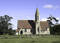
Bettisfield Church - geograph.org.uk - 224951.jpg
Bettisfield Church
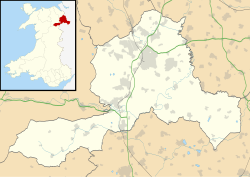
Wrexham UK location map.svg
Red pog.svg
Bettisfield
Location within Wrexham
OS grid reference SJ459351
Community
Principal area
Preserved county
Country Wales
Sovereign state United Kingdom
Post town WHITCHURCH
Postcode district SY13
Dialling code 01948
Police North Wales
Fire North Wales
Ambulance Welsh
UK Parliament
Senedd Cymru – Welsh Parliament
List of places
UK
Wales
Wrexham
52°54′47″N2°48′18″W / 52.913°N 2.805°W / 52.913; -2.805

Bettisfield (Welsh : Llys Bedydd; standardised : Bettisfield [i] ) is a village of about 150 dwellings in Wrexham County Borough, Wales and stands on the Wales-England border, and in the community of Maelor South. It lies south of the Llangollen Canal on the border with Shropshire, England within the historic English Maelor region which was formerly part of the historic county of Flintshire. The village lies close to Fenn's, Whixall and Bettisfield Mosses, an area of peat bog which was declared a national nature reserve in 1996 because of its importance for wildlife. The English market towns of Whitchurch, Ellesmere and Wem each lie about 6 miles distant to the northeast, west and southeast respectively.

It is described in the Domesday book (1086) within the Cheshire Hundred of Dudeston, recording 28 households and a value to Lord Edwin in 1066 of £18 9s, reducing to £3 in 1086. [2]

The village no longer has a shop, post office, pub, smithy or baker. [3]

Politician and poet John Hanmer, 1st Baron Hanmer (1809-1881) is buried in Bettisfield churchyard. [4]
Notes

  1. 1 2 Alternatively the English name may be used in Welsh, following the Welsh Language Commissioner's standardisation policy. [1]

Related Research Articles

<span class="mw-page-title-main">Flintshire</span> County in Wales

Flintshire is a county in the north-east of Wales. It borders the English ceremonial counties of Merseyside and Cheshire, across the Dee Estuary to the north and by land to the east respectively, Wrexham County Borough to the south, and Denbighshire to the west. Connah's Quay is the largest town, while Flintshire County Council is based in Mold.

<span class="mw-page-title-main">Bangor-on-Dee</span> Village in Wales

Bangor-on-Dee is a village and community in Wrexham County Borough, Wales, on the banks of the River Dee. Until 1974 it was in the exclave of Flintshire known as the Maelor Saesneg, and from 1974 to 1996 in the county of Clwyd.

<span class="mw-page-title-main">David Hanmer</span>

Sir David Hanmer, KS, SL (c.1332–1387) was a fourteenth century Anglo-Welsh Justice of the King's Bench from Hanmer, Wales, best known as Owain Glyndŵr's father-in-law and the father of Glyndŵr's chief supporters.

<span class="mw-page-title-main">Maelor</span> Area of Wales

The Maelor is an area of north-east Wales along the border with England. It is now entirely part of Wrexham County Borough. The name Maelor is an old Welsh word: it can be translated as "land of the prince", from mael ("prince") and llawr.

<span class="mw-page-title-main">Maelor Saesneg</span> Area of Wrexham County Borough, east of the River Dee

Maelor Saesneg, also known as English Maelor, comprises one half of the Maelor region on the Welsh side of the Wales-England border, being the area of the Maelor east of the River Dee. The region has changed counties several times, previously being part of Cheshire and later a detached portion of Flintshire. The area is currently in Wales, despite its name, and administered as part of Wrexham County Borough.

<span class="mw-page-title-main">Overton-on-Dee</span> Village in Wales

Overton or Overton-on-Dee is a village and community in Wrexham County Borough, Wales. It is situated close to the Welsh-English border on the edge of an escarpment that winds its way around the course of the River Dee, from which Overton-on-Dee derives its name.

<span class="mw-page-title-main">Fenn's, Whixall and Bettisfield Mosses National Nature Reserve</span> Nature reserve in England and Wales

Fenn's, Whixall and Bettisfield Mosses National Nature Reserve is a national nature reserve (NNR) which straddles the border between England and Wales, near Whixall and Ellesmere in Shropshire, England and Bettisfield in Wrexham County Borough, Wales. It comprises three peat bogs, Bettisfield Moss, Fenn's Moss and Whixall Moss. With Wem Moss and Cadney Moss, they are collectively a Site of Special Scientific Interest called The Fenn's, Whixall, Bettisfield, Wem & Cadney Moss Complex and form Britain's third-largest lowland raised bog, covering 2,388 acres (966 ha). The reserve is part of the Midland Meres and Mosses, an Important Plant Area which was declared a Wetland of International Importance under the Ramsar Convention in 1997. It is also a European Special Area of Conservation.

Maelor was a rural district in the administrative county of Flintshire, Wales, from 1894 to 1974. The area approximated to the hundred of Maelor or English Maelor, and was notable for forming a detached part of the county, surrounded by Cheshire, Denbighshire and Shropshire. The administrative centre was located at Overton.

<span class="mw-page-title-main">Hope, Flintshire</span> Village in Flintshire, Wales

Hope is a small village and community in Flintshire, north-east Wales. The village is located approximately 3 miles / 4.5 km from the Wales-England border, on the course of the River Alyn, and less than 5 miles from Wrexham.

<span class="mw-page-title-main">Erbistock</span> Village in Wales

Erbistock is a village and community in Wrexham County Borough, Wales. The village lies on the banks of the River Dee.

<span class="mw-page-title-main">Hanmer, Wrexham</span> Village in Wrexham County Borough, Wales

Hanmer is a village and community in Wrexham County Borough, Wales. At the 2001 Census the population of the Hanmer community area, which includes Hanmer village itself, Horseman's Green, Halghton and Arowry along with a number of small hamlets, was recorded at 726, reducing to 665 at the 2011 Census.

<span class="mw-page-title-main">Whixall</span> Village in Shropshire, England

Whixall is, by land area, the third largest inland village in England and a civil parish in Shropshire, England. It is documented in the Domesday Book as having been in existence in 1086.

<span class="mw-page-title-main">Willington Worthenbury</span> Community in Wrexham County Borough, Wales

Willington Worthenbury is a community in Wrexham County Borough, Wales, and is situated near the England–Wales border.

<span class="mw-page-title-main">Arowry</span> Village in Wales

Arowry is a village in the community of Hanmer in the rural south-east of Wrexham County Borough, Wales, near the border with England. The origin of its name is unclear but is thought to have a Welsh-language root. It has also been referred to as "Big Arowry", or "Great Arowry", in order to distinguish it from the hamlet of Little Arowry around a mile to the north near Horseman's Green. "Big Arowry" is the recommended name by the Welsh Language Commissioner.

<span class="mw-page-title-main">England–Wales border</span> National boundary between England and Wales

The England–Wales border, sometimes referred to as the Wales–England border or the Anglo-Welsh border, runs for 160 miles (260 km) from the Dee estuary, in the north, to the Severn estuary in the south, separating England and Wales.

<span class="mw-page-title-main">Oldcastle, Cheshire</span> Former civil parish in Cheshire, England

Oldcastle is a former civil parish, now in the parishes of Malpas and Threapwood, in the Cheshire West and Chester district and ceremonial county of Cheshire in England. In 2001 it had a population of 54.

<span class="mw-page-title-main">Maelor South</span> Community in Wrexham County Borough, Wales

Maelor South is a community in the area of Maelor Saesneg, Wrexham County Borough, Wales. It contains the villages of Penley and Bettisfield along with a number of other small hamlets and is represented by the Maelor South Community Council. At the time of the 2001 census, the community area had a total population of 1,137 people, increasing to 1,268 at the 2011 Census.

<span class="mw-page-title-main">Whitewell, Wrexham</span> Rural settlement in Wales

Whitewell is a dispersed rural settlement, and surrounding ecclesiastical parish, in the community of Bronington, in the east of Wrexham County Borough, Wales.

Tybroughton, occasionally written Ty Broughton, is the name of a former civil parish, historically in the Maelor Saesneg area of Flintshire, Wales and now in Wrexham County Borough. The rather isolated rural area contains no nucleated villages, although there are a few small hamlets such as Eglwys Cross.

<span class="mw-page-title-main">Halghton</span> Human settlement in Wales

Halghton is a dispersed settlement and former civil parish in the east of Wrexham County Borough, Wales. It is part of the community of Hanmer.

References

  1. "List of Standardised Welsh Place-names". GOV.WALES. Retrieved 26 December 2021.
  2. "Bettisfield | Domesday Book". Archived from the original on 5 December 2013. Retrieved 21 April 2014.
  3. "Bettisfield Village Web" . Retrieved 27 January 2014.
  4. Wikisource-logo.svg This article incorporates text from a publication now in the public domain : Porter, Bertha (1890). "Hanmer, John (1809-1881)". In Stephen, Leslie; Lee, Sidney (eds.). Dictionary of National Biography . Vol. 24. London: Smith, Elder & Co. p. 295.