Broughton, Wrexham

Last updated • 2 min readFrom Wikipedia, The Free Encyclopedia

Broughton
Mossvalley boating.jpg
Moss Valley
Wrexham UK location map.svg
Red pog.svg
Broughton
Location within Wrexham
Population7,454 (2011)
OS grid reference SJ307526
Community
  • Broughton
Principal area
Country Wales
Sovereign state United Kingdom
Post town WREXHAM
Postcode district LL11
Dialling code 01978
Police North Wales
Fire North Wales
Ambulance Welsh
UK Parliament
Senedd Cymru – Welsh Parliament
List of places
UK
Wales
Wrexham

53°03′58″N3°01′59″W / 53.066°N 3.033°W / 53.066; -3.033

Contents

Wales Wrexham Community Broughton map.svg
Map of the community

Broughton is a community in Wrexham County Borough, Wales. It has an area of 469 hectares and had a population of 6,498 in the 2001 census, increasing to 7,454 at the 2011 Census. [1] The area is dominated by the Moss Valley, which was known for its coal mining. Today it is operated as a country park, and there is a golf course of the same name in the vicinity.

History

Broughton was recorded in the reign of Henry VII as one of the townships of the manor of Eglwysegle (a name preserved in the area known as Eglwyseg near Llangollen), part of the lordship of Bromfield. The Wrexham historian Alfred Neobard Palmer noted:

Three villages [called Broughton] are situated in that part of Wales which was settled by Englishmen. They appear in Domesday as "Brochetune" or "Broctune," which can hardly mean anything else than "Brook-town". The brook which may have given the Bromfield Broughton its name is now almost always dry, but "Rhyd Broughton" (or Broughton ford) preserves the memory of it. [2]

Under the ecclesiastical administration the township of Broughton was part of the parish of Wrexham, and later of Brymbo. Population changes led to it being made a parish in its own right in 1909. [3]

The corresponding civil parish of Broughton, which was ultimately based on the boundaries of the ancient township, became the community of Broughton under the terms of the Local Government Act 1972. [4] It today contains the villages of Moss, Pentre Broughton, Brynteg, New Broughton, Southsea and Caego. [5] The majority of the villages date from the 19th century, when the area became heavily industrialised through coal mining and its proximity to the Brymbo Steelworks. [6] A number of coal mines were located in the area known as Moss Valley, [7] along with a number in Pentre Broughton near Brymbo such as the Brynmally and Pwll Cadi collieries. [8] Most of the area's coal mines had closed by the 1930s and the Moss Valley has now been reclaimed as a park. [7] Continuing development has urbanised much of the rest of the community's area, with some agricultural land remaining in the south and east. The Moss Valley Golf Club was built in the 1980s by five designers, and was initially run by the local council. [9]

Related Research Articles

<span class="mw-page-title-main">Wrexham</span> City in north-east Wales

Wrexham is a city and the administrative centre of Wrexham County Borough in Wales. It is located between the Welsh mountains and the lower Dee Valley, near the border with Cheshire in England. Historically in the county of Denbighshire, and later the county of Clwyd in 1974, it has been the principal settlement of Wrexham County Borough since 1996.

<span class="mw-page-title-main">Chirk</span> Town in Wales

Chirk is a town and community in Wrexham County Borough, Wales, 10 miles south of Wrexham, between it and Oswestry. At the 2011 census, it had a population of 4,468. Historically in the traditional county of Denbighshire, and later Clwyd, it has been part of Wrexham County Borough since a local government reorganisation in 1996. The border with the English county of Shropshire is immediately south of the town, on the other side of the River Ceiriog.

<span class="mw-page-title-main">Wrexham County Borough</span> County borough in Wales

Wrexham County Borough is a county borough, with city status, in the north-east of Wales. It borders the English ceremonial counties of Cheshire and Shropshire to the east and south-east respectively along the England–Wales border, Powys to the south-west, Denbighshire to the west and Flintshire to the north-west. The city of Wrexham is the administrative centre. The county borough is part of the preserved county of Clwyd.

<span class="mw-page-title-main">Coedpoeth</span> Village in Wales

Coedpoeth is a village and community in Wrexham County Borough, Wales. The built-up area with Minera had a population of 5,723 in the 2011 census.

<span class="mw-page-title-main">Abenbury</span> Community in Wrexham County Borough, Wales

Abenbury is a community in Wrexham County Borough, Wales. It is situated south-east of Wrexham city and includes the village of Pentre Maelor and part of the Wrexham Industrial Estate.

The Wrexham and Minera Railway or Wrexham and Minera Branch was a railway line in North Wales between the city of Wrexham, the village of Brymbo where it served the Brymbo Steelworks, and the lead mines and limeworks at Minera. A further branch ran from Brymbo to Coed Talon, where it connected with lines to Mold. The system was constructed in several stages between 1844 and 1872, while the various lines making up the system closed in 1952, 1972 and 1982.

<span class="mw-page-title-main">Minera</span> Village in Wales

Minera is a village and community in Wrexham County Borough, Wales. It adjoins the village of Coedpoeth.

<span class="mw-page-title-main">Moss Valley, Wrexham</span> Area and country park in Wrexham County Borough, Wales

The Moss Valley is an area and country park in Wrexham County Borough, Wales. The area, informally known as "The Moss" and The Aggey by local people, has an extensive coal mining history.

<span class="mw-page-title-main">Brymbo</span> Village in Wales

Brymbo is a village and community in Wrexham County Borough, Wales. It lies in the hilly country to the west of Wrexham city, largely surrounded by farmland.

<span class="mw-page-title-main">Erbistock</span> Village in Wales

Erbistock is a village and community in Wrexham County Borough, Wales. The village lies on the banks of the River Dee.

<span class="mw-page-title-main">Gwersyllt</span> Village in Wales

Gwersyllt is an urban village and community in Wrexham County Borough, Wales.

<span class="mw-page-title-main">Stansty</span> Area of Wrexham, Wales

Stansty is an area and electoral ward in Wrexham County Borough, Wales, lying to the immediate north-west of the city of Wrexham. It is a former civil parish and township. Stansty is also an electoral ward to Wrexham County Borough Council. The ward population as taken at the 2011 Census was 2,114.

<span class="mw-page-title-main">History of Wrexham</span>

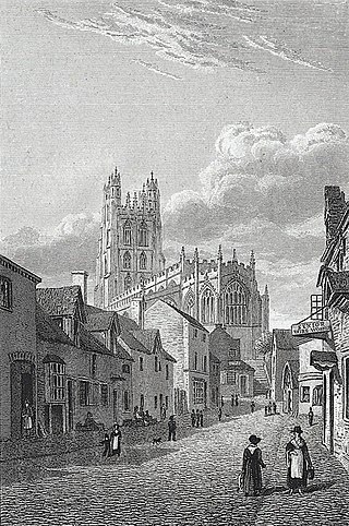
The city of Wrexham in north-east Wales has a history dating back to ancient times. The former market town was the site of heavy industry in the 19th and 20th centuries, and is now an active commercial centre. Wrexham was granted city status in 2022.

<span class="mw-page-title-main">Esclusham</span> Community in Wrexham County Borough, Wales

Esclusham is a community and electoral ward in Wrexham County Borough, Wales.

<span class="mw-page-title-main">Caego</span> Village in Wales

Caego is a village in Wrexham County Borough, Wales, immediately to the west of the city of Wrexham in the community of Broughton. It is contiguous with the neighbouring larger village of New Broughton; the main road passing through the centre of the village is the B5101. Its name can perhaps be translated as "the field (cae) of the smith".

Pentre Broughton is a formerly industrial village in the community of Broughton in Wrexham County Borough, Wales. It is contiguous with the neighbouring villages of Moss and Brynteg.

Moss Valley branch was a two mile long single track line built by the Great Western Railway in what is now the county borough of Wrexham, Wales. It ran from a junction with the Wrexham and Minera Railway at Moss Valley Junction to Moss Halt via three intermediate stations: Gatewen Halt, Pentre Broughton Halt, and Gwersyllt Hill Halt.

<span class="mw-page-title-main">Brymbo railway branch lines</span>

The Brymbo railway branch lines served the rich reserves of coal, iron, limestone and other minerals in an area around Brymbo to the west of Wrexham in Wales. Coalowners and others needed transport to get their products to market and lines were built from the main line into the mineral-bearing area. The topography was difficult and gradients were steep. The Great Western Railway became dominant, but a rival company built a competing line and branches.

References

  1. "Community population 2011" . Retrieved 18 November 2015.
  2. Palmer, A. N. and Owen, E. A History of Ancient Tenures of Land in North Wales and the Marches, 2nd ed, 1910, p.245
  3. "Broughton, St Paul's". GENUKI . Retrieved 25 April 2016.
  4. "Wrexhm County Borough Council" (PDF). NWN Media. Retrieved 25 April 2016.
  5. "Broughton Estate Office". Wrexham County Borough Council. Retrieved 25 April 2016.
  6. The Official Guide to the Great Western Railway. 1897. p. 306.
  7. 1 2 "Moss Valley Country Park" (PDF). Retrieved 25 April 2016.
  8. Nurse, Keith (1998). Footsteps to the Past: A Welsh Quest. K. Nurse. p. 52. ISBN   978-0-9534219-0-9.
  9. "Moss Valley Golf Course". Welshgolfcourses.com. Retrieved 25 April 2016.