Llay

Last updated • 3 min readFrom Wikipedia, The Free Encyclopedia

Llay
Llay Miners Welfare Institute - geograph.org.uk - 204700.jpg
The Miners' Welfare Institute, the largest such building in the country at completion in 1931
Wrexham UK location map.svg
Red pog.svg
Llay
Location within Wrexham
Population4,814 (2011 Census) [1]
OS grid reference SJ334561
Community
  • Llay
Principal area
Preserved county
Country Wales
Sovereign state United Kingdom
Post town WREXHAM
Postcode district LL12
Dialling code 01978
Police North Wales
Fire North Wales
Ambulance Welsh
UK Parliament
Senedd Cymru – Welsh Parliament
List of places
UK
Wales
Wrexham

53°05′53″N2°59′42″W / 53.098°N 2.995°W / 53.098; -2.995

Contents

Wales Wrexham Community Llay map.svg
Map of the community

Llay (Welsh : Llai; meaning meadow; Welsh pronunciation ) is a village and community in Wrexham County Borough, Wales.

It borders several other villages including Gwersyllt and Gresford. At the 2001 Census, the total population of the community of Llay, including Llay village, was 4,905, [2] reducing to 4,814 at the 2011 Census.

Prior to the 1960s, Llay was a coal mining village. Llay Main Colliery, at one time the largest colliery in Wales and after 1952 the deepest pit in the UK, was a major employer for the area before its coal reserves were exhausted in 1966. [3]

History

Llay first appears in mediaeval records as a hamlet - a small settlement without a church - of the township and manor of Burton. [4] It later formed an outlying part of the parish of Gresford, but the relatively late growth of the village is shown by the fact that the first church service was not held there until 1916, and its church was not completed until 1925. [5] Llay was eventually made a separate parish in its own right in 1944. [5]

Much of the growth of the village is connected with the development of coal mines, particularly the Llay Main Colliery. It was first established by the industrialist Sir Arthur Markham in 1913, but sinking of the shafts was interrupted by the First World War and by Markham's death in 1916. [3] The shafts were eventually completed in 1921, and coal production started in 1923. The colliery had a reputation as a well-run, modern pit with a relatively satisfied workforce, and by the 1930s was employing more than 3,000 men, 450 families being installed in new housing schemes in Llay. [3]

Today

There is a country park in Llay called Alyn Waters country park, which has a sister country park in Gwersyllt of the same name. The site includes a children's play park and pathways for pedestrian and cycle access through the forest. There were numerous original artworks around the park such as carved wooden animals along the paths, however many of the artworks have now been stolen or destroyed. There is a small golfing range at the park, and other sporting events take place on the large playing fields, such as football (home of Llay United Youth Football Club) and archery.

There are four churches in the village of Llay; the Roman Catholic St. Francis of Assisi, Llay Community Church of the Nazarene, St. Martin of Tours of the Church in Wales and the Bethel Baptist Church.

There are three drinking establishments, which are the Royal British Legion club, the Crown public house and Llay Miners' Welfare, also known as Miners' Welfare Institute. The Welfare had its grand opening in 1931 after negotiations in 1929 for monies to build a Miners' Institute with sports facilities. The Welfare was refurbished in 2005 after receiving a grant for the work.

There is an industrial estate in Llay, being similar in size to the whole village itself, which it includes a Sharp Electronics factory.

The Llay Resource Centre was opened in 2005 by Chris Armstrong. [6] The Resource Centre features a library, cafe, youth club and runs various courses and groups for the local community. [7]

Notable residents

Related Research Articles

<span class="mw-page-title-main">Wrexham</span> City in north-east Wales

Wrexham is a city and the administrative centre of Wrexham County Borough in Wales. It is located between the Welsh mountains and the lower Dee Valley, near the border with Cheshire in England. Historically in the county of Denbighshire, and later the county of Clwyd in 1974, it has been the principal settlement of Wrexham County Borough since 1996.

<span class="mw-page-title-main">Wrexham County Borough</span> County borough in Wales

Wrexham County Borough is a county borough, with city status, in the north-east of Wales. It borders the English ceremonial counties of Cheshire and Shropshire to the east and south-east respectively along the England–Wales border, Powys to the south-west, Denbighshire to the west and Flintshire to the north-west. The city of Wrexham is the administrative centre. The county borough is part of the preserved county of Clwyd.

<span class="mw-page-title-main">Rhosllanerchrugog</span> Village in Wales

Rhosllanerchrugog is a village and community in Wrexham County Borough, Wales. It lies within the historic county of Denbighshire. The entire built-up area including Penycae, Ruabon and Cefn Mawr had a population of 25,362.

<span class="mw-page-title-main">Rhosrobin</span> Village in Wrexham, Wales

Rhosrobin is a village situated in Wrexham County Borough, Wales, about 2 miles (3.2 km) north west of Wrexham city centre, close to the A483 road.

<span class="mw-page-title-main">Gresford</span> Village in Wales

Gresford is a village and community in Wrexham County Borough, Wales.

<span class="mw-page-title-main">Gresford disaster</span> 1934 coal mining disaster near Wrexham, Wales

The Gresford disaster occurred on 22 September 1934 at Gresford Colliery, near Wrexham, when an explosion and underground fire killed 261 men. Gresford is one of Britain's worst coal mining disasters: a controversial inquiry into the disaster did not conclusively identify a cause, though evidence suggested that failures in safety procedures and poor mine management were contributory factors. Further public controversy was caused by the decision to seal the colliery's damaged sections permanently, meaning that the bodies of only 8 of the miners were ever recovered. Two of the three rescue men who died were brought out leaving the third body in situ until recovery operations began the following year.

<span class="mw-page-title-main">Moss Valley, Wrexham</span> Area and country park in Wrexham County Borough, Wales

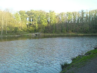
The Moss Valley is an area and country park in Wrexham County Borough, Wales. The area, informally known as "The Moss" and The Aggey by local people, has an extensive coal mining history.

<span class="mw-page-title-main">Wrexham (Senedd constituency)</span> Constituency of the Senedd

Wrexham is a constituency of the Senedd. It elects one Member of the Senedd by the first past the post method of election. Also, however, it is one of nine constituencies in the North Wales electoral region, which elects four additional members, in addition to nine constituency members, to produce a degree of proportional representation for the region as a whole.

<span class="mw-page-title-main">Gwersyllt</span> Village in Wales

Gwersyllt is an urban village and community in Wrexham County Borough, Wales.

<span class="mw-page-title-main">Rhosddu</span> Community in Wrexham County Borough, Wales

Rhosddu is a suburb and community in Wrexham County Borough, Wales, covering the north-western parts of the city of Wrexham and comprises the wards of Grosvenor, Garden Village and Stansty.

<span class="mw-page-title-main">Stansty</span> Area of Wrexham, Wales

Stansty is an area and electoral ward in Wrexham County Borough, Wales, lying to the immediate north-west of the city of Wrexham. It is a former civil parish and township. Stansty is also an electoral ward to Wrexham County Borough Council. The ward population as taken at the 2011 Census was 2,114.

<span class="mw-page-title-main">Garden Village, Wrexham</span> Suburb and ward of Wrexham, Wales

Garden Village is a suburb of the city of Wrexham and an electoral division (ward) in the community of Rhosddu in Wrexham County Borough, Wales. The population of the ward at the 2011 census was 2,035 It lies to the west of Chester Road and borders the wards of Stansty to the south and east, Gwersyllt East and South to the north west, Little Acton and Acton to the west, and a small section of Gresford to the north.

Oakdale is a large village in Caerphilly county borough, Wales, 9½ miles north of Caerphilly itself, within the historic boundaries of Monmouthshire. Situated in the Sirhowy valley, it is 1.5 miles (2.4 km) east of Blackwood, with which it forms a conurbation. At the 2001 census Oakdale had a population of 4,478.

<span class="mw-page-title-main">Pandy, Gwersyllt</span> Village in Wrexham County Borough, Wales

Pandy is a village near Gwersyllt and Rhosrobin, in Wrexham, Wrexham County Borough, Wales. The main entrance to Gresford Colliery stood in the village. Gresford Colliery Social Club is in the village and alongside it a memorial to the Gresford Disaster, which killed 266 men on September 22, 1934.

<span class="mw-page-title-main">Caerau, Bridgend</span>

Caerau is a former mining village in the community of Maesteg, Bridgend County Borough, Wales, located approximately 2 miles north of the centre of Maesteg town in the Llynfi Valley. Caerau, surrounded by mountainous terrain and forestry, is one of the border points between Bridgend County Borough and Neath Port Talbot County Borough, bordered to the north by Croeserw and Cymmer, Neath Port Talbot. Caerau, borders Dyffryn and Spelter to the south in Nantyffyllon, Maesteg.

<span class="mw-page-title-main">Gresford Colliery</span> Former coal mine in Gresford, Wrexham, Wales

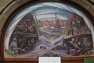
Gresford Colliery was a coal mine located a mile from the North Wales village of Gresford, near Wrexham.

<span class="mw-page-title-main">Tanyfron</span> Village in Wrexham County Borough, Wales

Tanyfron is a village in Wrexham County Borough in Wales. At the time of the 2001 census, the population of area Wrexham 006A, which includes Tanyfron and a number of other small settlements, was 1,347. The village is part of the local government Community of Brymbo and is in the Vron electoral ward. The built-up area had a population of well over 2,000 as of the 2011 census.

Sydallt is a village in Gwersyllt community, Wrexham County Borough, north Wales. It had a population of 422 as of the 2011 UK census.

References

  1. "Community population 2011" . Retrieved 18 November 2015.
  2. "2001 Census: Llay (Parish)". Office for National Statistics. Retrieved 10 November 2008.
  3. 1 2 3 Llay Main Colliery, BBC North East Wales
  4. Palmer, A. N. A History of Ancient Tenures of Land in North Wales and the Marches, 1910, p.232
  5. 1 2 Llay, St Martin, GENUKI
  6. [ permanent dead link ], Minutes of Llay Community Committee. 23 February 2005.
  7. "Llay Park Resource Centre | Llay.Org". Archived from the original on 15 August 2013. Retrieved 15 August 2013.