Isycoed

Last updated
Isycoed
Village and community
St. Paul's Church at Isycoed Geograph-419052-by-Geoff-Evans.jpg
St. Paul's Church at Isycoed
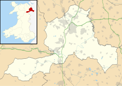
Wrexham UK location map.svg
Red pog.svg
Isycoed
Location within Wrexham
Principal area
Country Wales
Sovereign state United Kingdom
Police North Wales
Fire North Wales
Ambulance Welsh
List of places
UK
Wales
Wrexham

53°02′45″N2°53′33″W / 53.04573°N 2.8924°W / 53.04573; -2.8924

Contents

Wales Wrexham Community Isycoed map.svg
Map of the community

Isycoed (Welsh : Is-y-coed [1] ) is a village and community in Wrexham County Borough, Wales. It lies around 5 miles to the east of Wrexham, close to the River Dee on the border with England. [2] [3] [4]

There is a primary school in Bowling Bank, and a late-Georgian church, dedicated to St. Paul, in Isycoed village, [5] which was designated as a Grade II listed building on 20 June 1996.

It will be the location of the 2025 Wrexham National Eisteddfod. [6]
Governance

The area was traditionally considered part of the parish of Holt, but was made a separate parish in 1827, incorporating the townships of Cacca Dutton, Dutton Diffaeth, Dutton y Bran, Ridley, and Sutton. [5] The civil parish, established in 1935, was replaced by the Community of Isycoed under the Local Government Act 1972. [7]

The community today contains the village of the same name, and the hamlets of Bowling Bank, and Ridleywood; part of the Wrexham Industrial Estate occupies the western side of the community area. At the time of the 2001 census, the population was 348, [8] increasing to 388 at the 2011 Census. [9]

St Paul's Church

The first church on this site was built in 1718 and it was replaced by another building in 1742. The present church was built in 1829 and is dedicated to St Paul. It is built of brown brick with light headers to give a chequer-board effect. The side door and the adjacent windows have been blocked up. The medium-height tower is at the west end, the top stage is octagonal with a leaded roof and it is surmounted by a weather vane. The church was designated as a Grade II listed building on 20 June 1996, assessed as being "a good example of an earlier C19 church". [10]

Related Research Articles

<span class="mw-page-title-main">Clwyd</span> Preserved county of Wales

Clwyd is a preserved county of Wales, situated in the north-east corner of the country; it is named after the River Clwyd, which runs through the area. To the north lies the Irish Sea, with the English ceremonial counties of Cheshire to the east and Shropshire to the south-east. Powys and Gwynedd lie to the south and west respectively. Clwyd also shares a maritime boundary with Merseyside along the River Dee. Between 1974 and 1996, a slightly different area had a county council, with local government functions shared with six district councils. In 1996, Clwyd was abolished, and the new principal areas of Conwy County Borough, Denbighshire, Flintshire and Wrexham County Borough were created; under this reorganisation, "Clwyd" became a preserved county, with the name being retained for certain ceremonial functions.

Llanwrtyd is a small settlement in Powys, mid-Wales, giving its name to a community, in the historic county of Brecknockshire (Breconshire), through which flows the River Irfon. It lies 1.5 miles north of the town of Llanwrtyd Wells.

<span class="mw-page-title-main">Wrexham County Borough</span> County borough in Wales

Wrexham County Borough is a county borough, with city status, in the north-east of Wales. It borders the English ceremonial counties of Cheshire and Shropshire to the east and south-east respectively along the England–Wales border, Powys to the south-west, Denbighshire to the west and Flintshire to the north-west. The city of Wrexham is the administrative centre. The county borough is part of the preserved county of Clwyd.

<span class="mw-page-title-main">Overton-on-Dee</span> Village in Wales

Overton or Overton-on-Dee is a village and community in Wrexham County Borough, Wales. It is situated close to the Welsh-English border on the edge of an escarpment that winds its way around the course of the River Dee, from which Overton-on-Dee derives its name.

<span class="mw-page-title-main">Chirk Castle</span> Castle in north-east Wales, built in 1295

Chirk Castle is a Grade I listed castle located in Chirk, Wrexham County Borough, Wales, 1.5 mi (2.4 km) from Chirk railway station, now owned and run by the National Trust.

<span class="mw-page-title-main">Llandinam</span> Human settlement in Wales

Llandinam is a village and community in Montgomeryshire, Powys, central Wales, between Newtown and Llanidloes, located on the A470. As a community, Llandinam is made up of the village itself, small hamlets including Plas Dinam and Little London and several farms. The village itself has a population of around 576 with 56% born in Wales.

<span class="mw-page-title-main">Minera</span> Village in Wales

Minera is a village and community in Wrexham County Borough, Wales. It adjoins the village of Coedpoeth.

<span class="mw-page-title-main">Erbistock</span> Village in Wales

Erbistock is a village and community in Wrexham County Borough, Wales. The village lies on the banks of the River Dee.

<span class="mw-page-title-main">Llanfyllin</span> Human settlement in Wales

Llanfyllin is a market town and community in Powys, Wales. The community population in 2021 was 1,586 and the town's name means church or parish (llan) of St Myllin. The community includes the settlements of Bodfach, Ty Crwyn, Abernaint and several farms.

<span class="mw-page-title-main">Penley</span> Village in Wales

Penley is a village in the County Borough of Wrexham, in Wales close to the border with Shropshire, England, and had a population of 606 as of the 2011 census.

<span class="mw-page-title-main">Llanarmon Dyffryn Ceiriog</span> Village in Wrexham County Borough, Wales

Llanarmon Dyffryn Ceiriog is a village in Wrexham County Borough, Wales. It lies on the River Ceiriog and is at the end of the B4500 road, five miles (8 km) south-west of Glyn Ceiriog and ten miles (16 km) north-west of Oswestry. It is within the Ceiriog Valley ward, Clwyd South Senedd constituency and Clwyd South UK parliamentary constituency. It is in the community of Ceiriog Ucha.

<span class="mw-page-title-main">Llansannan</span> Human settlement in Wales

Llansannan is a rural village and community in Conwy County Borough, Wales. It lies on the bank of the River Aled and is about 8 miles to the south of Abergele and 9 miles (14 km) to the west of Denbigh. The population was 1,291 in 2001, with 67% able to speak Welsh. The figures for the 2011 census were: population 1,335 with 63% able to speak Welsh. The community includes the hamlets of Bylchau, Rhydgaled and Y Groes, and the lake Llyn Aled and reservoir Aled Isaf on Mynydd Hiraethog. Llansannan is in the traditional county of Denbighshire.

<span class="mw-page-title-main">Froncysyllte</span> Village in Wrexham County Borough, Wales

Froncysyllte, colloquially known as Fron, is a village in Wrexham County Borough, Wales and stands on the banks of the River Dee and the Llangollen Canal. It is situated on the main A5 road which runs from London to Holyhead. It is in the community of Llangollen Rural. The population was 606 as of 2011 UK census.

<span class="mw-page-title-main">Marchwiel</span> Village in Wales

Marchwiel is a village and community in Wrexham County Borough, Wales.

<span class="mw-page-title-main">Willington Worthenbury</span> Community in Wrexham County Borough, Wales

Willington Worthenbury is a community in Wrexham County Borough, Wales, and is situated near the England–Wales border.

<span class="mw-page-title-main">St Berres' Church, Llanferres</span> Church in Denbighshire, Wales

St Berres' Church, Llanferres, is in the village of Llanferres, Denbighshire, Wales on the A494 road between Mold and Ruthin. It is an Anglican church in the Bro Famau Group of Churches, the Mission Area of Mold, the archdeaconry of Wrexham and the diocese of St Asaph. The church is designated by Cadw as a Grade II listed building.

<span class="mw-page-title-main">Tanyfron</span> Village in Wrexham County Borough, Wales

Tanyfron is a village in Wrexham County Borough in Wales. At the time of the 2001 census, the population of area Wrexham 006A, which includes Tanyfron and a number of other small settlements, was 1,347. The village is part of the local government Community of Brymbo and is in the Vron electoral ward. The built-up area had a population of well over 2,000 as of the 2011 census.

<span class="mw-page-title-main">Manafon</span> Human settlement in Wales

Manafon is a small rural community located in the hills of Montgomeryshire, the Northern part of the Welsh county of Powys. The Parish focuses on the valley of the River Rhiew that runs west to east into the River Severn". The community of Manafon consists of "two main villages within about a mile of one another, Manafon and New Mills. The remainder of the population lives in scattered farms and dwellings and in the small rural settlement of The Green."

<span class="mw-page-title-main">Whitewell, Wrexham</span> Rural settlement in Wales

Whitewell is a dispersed rural settlement, and surrounding ecclesiastical parish, in the community of Bronington, in the east of Wrexham County Borough, Wales.

<span class="mw-page-title-main">Bangor Bridge</span> Bridge in Wrexham, Wales

Bangor Bridge is a Grade I listed bridge crossing the River Dee in Bangor-on-Dee, Wrexham County Borough, Wales. It is situated on the community boundary between Bangor-is-y-Coed and Sesswick. Located to the west of Bangor-on-Dee, it connects the village's high street and the A525 road bypass. The narrow bridge is a one-way traffic bridge, west to east, and is downstream (north) of the Bangor by-pass bridge.

References

  1. "Standardised Welsh Place names". www.welshlanguagecommissioner.wales. Retrieved 2023-03-29.
  2. Concise Road Atlas: Britain. AA Publishing. 2015. p. 48. ISBN   978-0-7495-7743-8.
  3. "Home - Isycoed Community Council". www.isycoedcommunitycouncil.gov.uk. Retrieved 2024-10-24.
  4. "Clwyd Powys Archaeological Trust - Historic Settlement Survey – Wrexham County Borough - Isycoed" (PDF). cpat.org.uk. Clwyd-Powys Archaeological Trust.
  5. 1 2 Isycoed, St Paul, GENUKI
  6. "National Eisteddfod reveals Wrexham site for 2025 – Isycoed !". Wrexham.com. Retrieved 2024-10-24.
  7. "Local Government Act 1972". National Archives. Legislation.gov.uk. Retrieved 2 May 2016.
  8. Isycoed Community, Office for National Statistics.
  9. "Community population 2011" . Retrieved 18 November 2015.
  10. "Church of St Paul, Isycoed". British Listed Buildings. Retrieved 2 May 2016.

Commons-logo.svg Media related to Isycoed at Wikimedia Commons