Bradley, Wrexham

Last updated

Bradley
Village
Heol-y-Parc, Bradley (geograph 2808828).jpg
Heol-y-Parc, Bradley
Wrexham UK location map.svg
Red pog.svg
Bradley
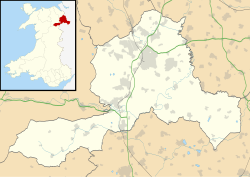
Location within Wrexham
OS grid reference SJ316537
Community
Principal area
Ceremonial county
Country Wales
Sovereign state United Kingdom
Post town WREXHAM
Postcode district LL11
Dialling code 01978
Police North Wales
Fire North Wales
Ambulance Welsh
UK Parliament
Senedd Cymru – Welsh Parliament
List of places
UK
Wales
Wrexham
53°04′43″N3°00′32″W / 53.0786°N 3.0089°W / 53.0786; -3.0089 Coordinates: 53°04′43″N3°00′32″W / 53.0786°N 3.0089°W / 53.0786; -3.0089

Bradley (Welsh : Bradle) is a village in Wrexham County Borough, Wales. Situated in the community of Gwersyllt, it is bounded by Alyn Waters Country Park to the north, the village of Gwersyllt to the west and south, and Bradley Hill, Wat's Dyke and the River Alyn to the east. The Bradley Built-up Area Sub-division (BUASD) is a subdivision of the Wrexham Built-up Area. [1]

The village is home to a cricket club, village hall, and a Toyota dealership at Lindop. Until 2009, there was also a Post Office and a Pub known as the "Queens Head", the latter being replaced with a housing estate.

Prior to the building of the 'Old Mill Estate' the village housing stock consisted primarily of Council houses. There are ruins of six mill cottages and part of the Bradley Wire Mill to the east of the village on the banks of the River Alyn. [2]

Bradley Park Rangers F.C. was a football club in the village between 1951 and 1965.
Related Research Articles

Wrexham Town and prospective city in north-east Wales

Wrexham is a market town and the administrative centre of Wrexham County Borough in Wales. It is located between the Welsh mountains and the lower Dee Valley, where it borders with the county of Cheshire in England. Historically in the county of Denbighshire, the town became part of the county of Clwyd in 1974 and then the principal settlement of the Wrexham County Borough in 1996.

River Dee, Wales River in Wales and England

The River Dee is a river in the United Kingdom. It flows through parts of both Wales and England, forming part of the border between the two countries.

Wrexham County Borough County borough in Wales

Wrexham County Borough is a county borough in the north-east of Wales. It borders England to the east and south-east, Powys to the south-west, Denbighshire to the west and Flintshire to the north-west. The county borough has a population of 136,055. The town of Wrexham is its largest settlement, which together with villages such as Gwersyllt, New Broughton, Bradley and Rhostyllen form a built-up area with 65,692 residents. Other villages in the county borough include Ruabon, Rhosllanerchrugog, Johnstown, Acrefair, Bangor-on-Dee, and Coedpoeth amongst other villages. The county borough has two outlying towns, Chirk and Holt, and various rural settlements in the county borough's large salient in the Ceiriog Valley, and the English Maelor.

Eccleston, Lancashire Village and civil parish in England

Eccleston is a village and civil parish of the Borough of Chorley in Lancashire, England. It is beside the River Yarrow, and was formerly an agricultural and later a weaving settlement.

Gresford Village in Wales

Gresford is a village and community in Wrexham County Borough, Wales.

Hope, Flintshire Human settlement in Wales

Hope is a small village and community in Flintshire, north-east Wales. The village is located approximately 3 miles / 4.5 km from the Wales-England border, on the course of the River Alyn, and less than 5 miles from Wrexham.

Rossett Village in Wrexham County Borough, Wales

Rossett is a village, community and electoral ward in Wrexham County Borough, Wales. Rossett is served by the A483 road.

Moss Valley, Wrexham Area and country park in Wrexham County Borough, Wales

The Moss Valley is an area and country park in Wrexham County Borough, Wales. The area, informally known as "The Moss" and The Aggey by local people, has an extensive coal mining history.

Wrexham (Senedd constituency) Constituency of the Senedd

Wrexham is a constituency of the Senedd. It elects one Member of the Senedd by the first past the post method of election. Also, however, it is one of nine constituencies in the North Wales electoral region, which elects four additional members, in addition to nine constituency members, to produce a degree of proportional representation for the region as a whole.

Summerhill is a semi-urban village in the suburbs of Wrexham, Wales and forms part of the community of Gwersyllt.

Gwersyllt Village in Wales

Gwersyllt is an urban village and community in Wrexham County Borough, Wales.

Llay Village in Wales

Llay is a village and community in Wrexham County Borough, Wales.

Stansty Human settlement in Wales

Stansty is an area and electoral ward in Wrexham County Borough, Wales, lying to the immediate north-west of the town of Wrexham. It is a former civil parish and township. Stansty is also an electoral ward to Wrexham County Borough Council. The ward population as taken at the 2011 Census was 2,114.

Garden Village, Wrexham Human settlement in Wales

Garden Village is a suburb of the town of Wrexham and an electoral division (ward) in the community of Rhosddu in Wrexham County Borough, Wales. The population of the ward at the 2011 Census was 2,035 It lies to the west of Chester Road and borders the wards of Stansty to the south and east, Gwersyllt East and South to the north west, Little Acton and Acton to the west, and a small section of Gresford to the north.

The town of Wrexham has two main town parks, these being Bellevue Park and Acton Park. On the outskirts of the town there is also open parkland on and surrounding the Erddig estate. There is also a town centre green.

Pandy, Gwersyllt

The Pandy is a village near Gwersyllt and Rhosrobin, in Wrexham, Wrexham County Borough, Wales. The main entrance to Gresford Colliery stood in the village. Gresford Colliery Social Club is in the village and alongside it a memorial to the Gresford Disaster, which killed 266 men on September 22, 1934.

Offa, Wrexham Community in Wrexham County Borough, Wales

Offa is a community and electoral ward in Wrexham County Borough, Wales, covering most of the south-western portion of the town of Wrexham. It is bordered by the communities of; Rhosddu, and Caia Park to the north, Abenbury to the east, Esclusham, and Marchwiel to the south, and Broughton, Coedpoeth, and Gwersyllt to the west.

Alyn Waters Country park in Wrexham County Borough

Alyn Waters is a country park situated between Gwersyllt and Llay in Wrexham County Borough, in the north-east of Wales, and is managed by Wrexham County Borough Council.

Clwydian Range and Dee Valley Area of Outstanding Natural Beauty in Wales

The Clwydian Range and Dee Valley is a designated Area of Outstanding Natural Beauty (AONB) and proposed national park, located in north-east Wales, covering the Clwydian Range, and the valley of the River Dee. Designated in 1985 as the Clwydian Range AONB, and expanded to its current form in 2011, the Area of Outstanding Natural Beauty includes: medieval field systems, open heather moorland, prehistoric hillforts, limestone crags, broad leaved woodland, wooded valleys, and farmland. In 2018, an estimated 1.1 million people visited six key sites across the AONB, generating approximately £24.1 million to the Welsh economy, according to Natural Resources Wales. The AONB falls within the jurisdiction of the local authorities of Denbighshire, Flintshire, and Wrexham County Borough, with the majority, 80% of the AONB in Denbighshire, and the remaining 20% split evenly between the other two authorities. The AONB is the largest of only five AONBs in Wales, and one of the 46 in the United Kingdom. Additionally, it is one of only 8 protected areas of Wales. Long-distance footpaths; Offa's Dyke Path, and the Clwydian Way pass through the AONB. The area of the Clwydian Range and Dee Valley AONB is 390 km2 (150 sq mi), and has been proposed by the Welsh Government to become Wales' fourth national park.

Wrexham Built-up area Urban area of Wrexham, Wales

The Wrexham Built-up area is an area of land defined by the United Kingdom Office for National Statistics (ONS) for population monitoring purposes. It is an urban conurbation fully within Wrexham County Borough and consists of the urban area centred on the town of Wrexham and the historically industrial settlements to the west including Gwersyllt, Rhostyllen, Brymbo, Bradley and New Broughton.

References

  1. "W37 Built-up Area – Wrexham BUA". statistics.data.gov.uk. Office for National Statistics. Archived from the original on 4 December 2021. Retrieved 26 December 2021.
  2. "Bradley Wire Mill, Bradley, Wrexham". Coflein. Archived from the original on 26 December 2021. Retrieved 26 December 2021.