Tregeiriog

Last updated

Tregeiriog
Tregeiriog - geograph.org.uk - 269220.jpg
Tregeiriog, in the community of Ceiriog Ucha
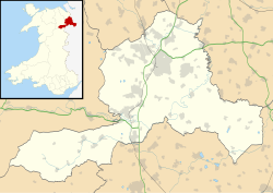
Wrexham UK location map.svg
Red pog.svg
Tregeiriog
Location within Wrexham
OS grid reference SJ177337
Community
Principal area
Country Wales
Sovereign state United Kingdom
Post town LLANGOLLEN
Postcode district LL20
Dialling code 01691
Police North Wales
Fire North Wales
Ambulance Welsh
UK Parliament
Senedd Cymru – Welsh Parliament
List of places
UK
Wales
Wrexham
52°53′42″N3°13′23″W / 52.895°N 3.223°W / 52.895; -3.223 Coordinates: 52°53′42″N3°13′23″W / 52.895°N 3.223°W / 52.895; -3.223

Tregeiriog (a Welsh name translating roughly as "settlement [on the] River Ceiriog") is a village in Wrexham County Borough, Wales. It is in the community of Ceiriog Ucha on the B4500 road between Glyn Ceiriog and Llanarmon Dyffryn Ceiriog.

The Battle of Crogen, between Welsh forces under Owain Gwynedd and English forces under Henry II of England, took place near Tregeirog in 1165.

Richard Jones Berwyn (1838–1917), one of the founders of the Welsh settlement in Patagonia, was a native of the village.

Tregeiriog was formerly in the old ecclesiastical parish of Llangadwaladr, of which it was a detached township, surrounded by other parishes. [1] The village of Tregeiriog and the surrounding area were transferred to the parish of Llanarmon Dyffryn Ceiriog in the late 1980s. [2] Although the village had no church, there was formerly a small Calvinistic Methodist chapel in Tregeiriog.

Tregeiriog was also in the corresponding civil parish of Llangadwaladr; subsequent to the 1972 Local Government Act it was placed in the community of Ceiriog Ucha.

The cartographer Samuel Lewis, in his 1849 edition of A Topographical Dictionary of Wales, recorded that "the inhabitants have a tradition, that there were formerly a church and a considerable town at Tregeiriog; and in ploughing the land, quantities of large paving stones have been thrown up at different times, which seemed to have been placed in regular order: the name of a farm, Pen-yr-hôwl, the "head of the street," is also adduced in corroboration". [3]
Related Research Articles

John Ceiriog Hughes Welsh poet and folk-tune collector, 1832–1887

John Ceiriog Hughes, was a Welsh poet and collector of Welsh folk tunes, sometimes termed a Robert Burns of Wales. He was born at Penybryn Farm, overlooking the village of Llanarmon Dyffryn Ceiriog in the Ceiriog Valley of north-east Wales, then in Denbighshire, now part of Wrexham County Borough. One of eight children, he was a favourite of his mother, Phoebe, a midwife and herbal-medicine expert.

Hawarden Human settlement in Wales

Hawarden is a village, community and electoral ward, in Flintshire, Wales. It is located as part of the Deeside conurbation on the Wales-England border and is home to Hawarden Castle. In the 2011 census, the ward of the same name had a population of 1,887, whereas the community of the same name, which also includes Ewloe, Mancot and Aston had a population of 13,920. The scenic, wooded Hawarden Park abuts the clustered settlement in the south. Hawarden Bridge constitutes distribution and industrial business premises beyond Shotton/Queensferry and the Dee. The west of the main street is called 'The Highway', its start marked by the crossroads with a fountain in the middle, near which are public houses, some centred on restaurants.

Tywyn Small coastal town in mid Wales

Tywyn, formerly spelled Towyn, is a town, community, and seaside resort on the Cardigan Bay coast of southern Gwynedd, Wales. It was previously in the historic county of Merionethshire. It is famous as the location of the Cadfan Stone, a stone cross with the earliest known example of written Welsh, and the home of the Talyllyn Railway.

Diocese of St Asaph Anglican diocese of the Church in Wales

The Diocese of Saint Asaph is a diocese of the Church in Wales in north-east Wales, named after Saint Asaph, its second bishop.

Ceiriog Valley Valley in north-east Wales

The Ceiriog Valley is the valley of the River Ceiriog in north-east Wales. Its Welsh name "Dyffryn Ceiriog" is the name of an electoral ward of Wrexham County Borough. The ward is the largest ward of the county borough by area and forms a strikingly-shaped salient of the county borough between Powys and Denbighshire.

Glyn Ceiriog Village and community in Wrexham County Borough, Wales

Glyn Ceiriog is the principal settlement of the Ceiriog Valley and a community in Wrexham County Borough, north-east Wales. Glyn Ceiriog translates simply as Ceiriog Valley, though there are other villages in the valley. The village and community is technically known, in traditional Welsh naming style, as Llansantffraid Glyn Ceiriog or sometimes Llansanffraid Glyn Ceiriog, which means church of St Ffraid in the Ceiriog Valley, but it has come to be known simply as Glyn Ceiriog, or even Glyn for short. The name Llansanffraid is now more associated with other villages of the same name.

Llanarmon Dyffryn Ceiriog Human settlement in Wales

Llanarmon Dyffryn Ceiriog is a village in Wrexham County Borough, Wales. It lies on the River Ceiriog and is at the end of the B4500 road, five miles (8 km) south-west of Glyn Ceiriog and ten miles (16 km) north-west of Oswestry. It is within the Ceiriog Valley ward, Clwyd South Senedd constituency and Clwyd South UK parliamentary constituency. It is in the community of Ceiriog Ucha.

Ceiriog Ucha Community in Wrexham County Borough, Wales

Ceiriog Ucha, also spelled as Ceiriog Uchaf, is a community in Wrexham County Borough, Wales. The community lies in the Ceiriog Valley and comprises the villages of Llanarmon Dyffryn Ceiriog and Tregeiriog as well as surrounding farmland and grouse and pheasant moors. It is a rural district set in low hills. The area is governed by Ceiriog Uchaf Community Council, and had a total population of 346, in 129 households, at the 2001 census. reducing to 317 in 2011.

Llanwnda is a rural village and parish to the north of the Welsh county of Pembrokeshire and part of the community of Pencaer. It lies some two miles northwest of the port of Fishguard and is inside the boundaries of the Pembrokeshire Coast National Park.

Llan and its variants are a common element of Celtic placenames in the British Isles and Brittany, especially of Welsh toponymy. In Welsh an name of a local saint or a geomorphological description follows the Llan morpheme to form a single word: for example Llanfair is the parish or settlement around the church of St. Mair. Goidelic toponyms end in -lann.

St Lythans Human settlement in Wales

St Lythans is an affluent hamlet and former parish in the Vale of Glamorgan, southeast Wales, just outside western Cardiff. It lies southwest of Culverhouse Cross, west of Wenvoe and southwest of Twyn-yr-Odyn and is also connected by road from Dyffryn and the Five Mile Lane in the west. It is one of the wealthiest communities in the Vale of Glamorgan, containing some notable mansions and cottages, valued on average at over £500,000 as of 2011. The megalithic St Lythans burial chamber, over 6000 years old, lies 1 km to the west of the village and the hamlet also contains the St.Lythans Parish Church or Church of St Bleddian, a Grade II* listed building.

Thomas Williams (1658–1726) was a Welsh Anglican priest and translator.

Llanarmon, Gwynedd Human settlement in Wales

Llanarmon(English: Garmon's Church) is a small village and former civil parish in the old commote of Eifionydd and Cantref Dunoding in the Welsh county of Gwynedd. The parish was abolished in 1934 and incorporated into Llanystumdwy. The village lies 4 miles (6.4 km) north east of Pwllheli and is close to the village of Llangybi, a holy well and the mountain of Carn Pentrych. A well-preserved 15th-century manor house at Penarth-fawr is maintained by Cadw, and another ancient monument Plas Du(Welsh: Black Place) is a well-preserved, substantial sub-medieval gentry house. It also has important historical associations; it was known as the centre of the Roman Catholic faith in the region and was the home of Thomas Owen, High Sheriff of Caernarfonshire from 1569, who was imprisoned for sheltering missionary priests in the house in 1571.

"The village is pleasantly situated in a fertile plain, and the neighbour-hood partakes of the pleasing scenery which prevails in this part of the country. The living is a rectory not in charge, annexed to that of Llangybi, in the archdeaconry of Merioneth, and diocese of Bangor, and in the patronage of the Bishop of Bangor. The church, dedicated to Saint Garmon, is an ancient and spacious structure in good repair : some additional windows have lately been inserted, previously to which alteration the interior was very dark."

Samuel Lewis, Topographical Dictionary of Wales (1833)

Llangybi, Gwynedd Human settlement in Wales

Llangybi(English: Cybi's Church) is a village and former civil parish in the Eifionydd area of the Welsh county of Gwynedd, near Llanarmon. The parish was abolished in 1934 and divided between Llanystumdwy and Llannor.

Llanarmon may refer to one of several villages in Wales:

St Garmon's Church may refer to one of several churches in Wales dedicated to Saint Germanus of Auxerre. The Welsh place name, Llanarmon, means "church of Saint Garmon".

Llanarmon Mynydd Mawr Human settlement in Wales

Llanarmon Mynydd Mawr, occasionally referred to as Llanarmon Fach, is an isolated rural parish in Powys, Wales. It was formerly in Denbighshire, and from 1974 to 1996 was in the county of Clwyd. It measures 2 square miles (5 km2) and has a population of 40.

Llangadwaladr, Powys

Llangadwaladr, formerly spelt Llancadwaladr in some sources, is an isolated mountain parish in Powys, Wales. It was formerly in the historic county of Denbighshire, and from 1974 to 1996 was in Clwyd. Some 7 miles west of the nearest town, Oswestry, it covers an area of sparsely settled hill farming country around the valley of the Afon Ysgwennant beneath Gyrn Moelfre.

Hayscastle Human settlement in Wales

Hayscastle or Hays-Castle is a village, parish and community of Pembrokeshire in West Wales, 7½ miles from Haverfordwest on the B4330 road.

Llanegryn Human settlement in Wales

Llanegryn is a village and a community in Gwynedd, north-west Wales. It was formerly part of the historic county of Merionethshire. It is located within Snowdonia National Park south of the Snowdonia (Eryri) mountain range. Travelling by road, it is around 4 miles (6 km) north-east of Tywyn and 17 miles (27 km) south-west of Dolgellau. The nearest railway stations are at Tonfanau and Llwyngwril, both less than 3 miles (5 km) away.

References

  1. Llangadwaladr, GENUKI
  2. St Cadwaladr's Church, Llangadwaladr Archived 2012-03-13 at the Wayback Machine , Llanfyllin Deanery
  3. Lewis, S. A topographical dictionary of Wales, 1845, p.494