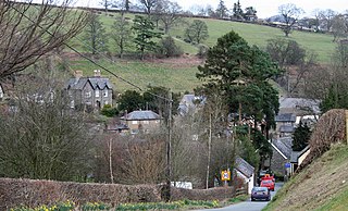
Llanrhaeadr-ym-Mochnant is a village, community and an ecclesiastical parish in the extreme north of Powys, Wales; about 9 miles west of Oswestry and 12 miles south of Llangollen, on the B4580. It lies near the foothills of the Berwyn mountains on the river Rhaeadr. At the top end of the valley is the Pistyll Rhaeadr waterfall, one of the Seven Wonders of Wales in the old rhyme. One mile north of the town is the hill Moel Hen-fache. The community includes the hamlet of Llanarmon Mynydd Mawr.

Chirk is a town and community in Wrexham County Borough, Wales, 10 miles south of the city of Wrexham, between it and Oswestry. At the 2011 census, it had a population of 4,468. Historically in the traditional county of Denbighshire, and later Clwyd, it has been part of Wrexham County Borough since a local government reorganisation in 1996. The border with the English county of Shropshire is immediately south of the town, on the other side of the River Ceiriog.

The Diocese of Saint Asaph is a diocese of the Church in Wales in north-east Wales, named after Saint Asaph, its second bishop.

The Ceiriog Valley is the valley of the River Ceiriog in north-east Wales. Its Welsh name "Dyffryn Ceiriog" is the name of an electoral ward of Wrexham County Borough. The ward is the largest ward of the county borough by area and forms a strikingly-shaped salient of the county borough between Powys and Denbighshire.

Rhydycroesau is a tiny village on the English-Welsh border, 3.25 miles (5.23 km) west of Oswestry on the B4580 road. It lies partly in the Shropshire parish of Oswestry Rural; the other part is in Montgomeryshire, Powys.

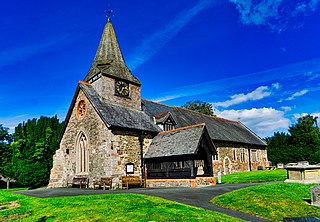
Llansilin is a village and local government community in Montgomeryshire, Powys, Wales, 5 miles (8 km) west of Oswestry. The community, which includes Llansilin village, a large rural area and the hamlets of Moelfre and Rhiwlas as well as the remote parish of Llangadwaladr, had a population of 648 at the 2001 census, increasing to 698 at the 2011 Census. There is also an electoral ward including the nearby village of Llanrhaeadr-ym-Mochnant with a population of 2,295.
Llansantffraid-ym-Mechain is a large village in Powys, mid Wales, close to the border with Shropshire in England, about 7 miles (11 km) south west of Oswestry and 8 miles (13 km) north of Welshpool. It is on the A495 road and is at the confluence of the River Vyrnwy and the Afon Cain. The population as of the 2011 UK Census was 1,415. The community includes the village of Deuddwr and several hamlets.

Glyn Ceiriog is the principal settlement of the Ceiriog Valley and a community in Wrexham County Borough, north-east Wales. Glyn Ceiriog translates simply as Ceiriog Valley, though there are other villages in the valley. The village and community is technically known, in traditional Welsh naming style, as Llansantffraid Glyn Ceiriog or sometimes Llansanffraid Glyn Ceiriog, which means church of St Ffraid in the Ceiriog Valley, but it has come to be known simply as Glyn Ceiriog, or even Glyn for short. The name Llansanffraid is now more associated with other villages of the same name.

Clwyd South is a constituency of the Senedd. It elects one Member of the Senedd by the first past the post method of election. Also, however, it is one of nine constituencies in the North Wales electoral region, which elects four additional members, in addition to nine constituency members, to produce a degree of proportional representation for the region as a whole.
Llansillin was a rural district in the administrative county of Denbighshire from 1894 to 1935.
Ceiriog was a rural district in the administrative county of Denbighshire from 1935 to 1974.

Llanfyllin is a market town, community and electoral ward in a sparsely populated area in Montgomeryshire, Powys, Wales. Llanfyllin's community population in 2011 was 1,532, of whom 34.1% could speak Welsh. Llanfyllin means church or parish (llan) of St Myllin. The community includes the tiny settlements of Bodfach, Ty Crwyn, Abernaint and several farms.

Llanarmon Dyffryn Ceiriog is a village in Wrexham County Borough, Wales. It lies on the River Ceiriog and is at the end of the B4500 road, five miles (8 km) south-west of Glyn Ceiriog and ten miles (16 km) north-west of Oswestry. It is within the Ceiriog Valley ward, Clwyd South Senedd constituency and Clwyd South UK parliamentary constituency. It is in the community of Ceiriog Ucha.
Ceiriog Ucha, also spelled as Ceiriog Uchaf, is a community in Wrexham County Borough, Wales. The community lies in the Ceiriog Valley and comprises the villages of Llanarmon Dyffryn Ceiriog and Tregeiriog as well as surrounding farmland and grouse and pheasant moors. It is a rural district set in low hills. The area is governed by Ceiriog Uchaf Community Council, and had a total population of 346, in 129 households, at the 2001 census. reducing to 317 in 2011.
Llan and its variants are a common element of Celtic placenames in the British Isles and Brittany, especially of Welsh toponymy. In Welsh an name of a local saint or a geomorphological description follows the Llan morpheme to form a single word: for example Llanfair is the parish or settlement around the church of St. Mair. Goidelic toponyms end in -lann.

The Battle of Crogen is an engagement said to have taken place in Wales during Henry II of England's summer 1165 campaign against an alliance of Welsh princedoms led by Prince Owain Gwynedd. Later Welsh chronicles recorded that a detachment of Welsh troops inflicted a number of casualties on the Anglo-Norman army in the Ceiriog Valley; Henry subsequently abandoned the campaign after an attempt to cross the Berwyn Mountains was thwarted by severe weather.
Thomas Williams (1658–1726) was a Welsh Anglican priest and translator.
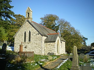
Llanarmon Mynydd Mawr, occasionally referred to as Llanarmon Fach, is an isolated rural parish in Powys, Wales. It was formerly in Denbighshire, and from 1974 to 1996 was in the county of Clwyd. It measures 2 square miles (5 km2) and has a population of 40.

Tregeiriog is a village in Wrexham County Borough, Wales. It is in the community of Ceiriog Ucha on the B4500 road between Glyn Ceiriog and Llanarmon Dyffryn Ceiriog.
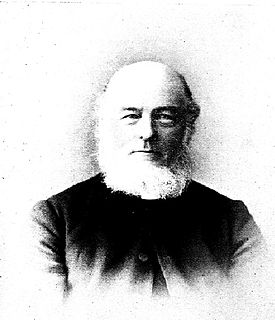
Rev. Elias Owen MA, F.S.A. was a Welsh cleric and antiquarian whose works include The Old Stone Crosses of the Vale of Clwyd, 1886 and Welsh Folk-Lore, 1896.


