Llanfechain

Last updated

Llanfechain
St Garmon's Church, Llanfechain.jpg
St Garmon's Church, Llanfechain
Powys UK location map.svg
Red pog.svg
Llanfechain
Location within Powys
Population465 (2011) [1]
OS grid reference SJ190203
Community
  • Llanfechain
Principal area
Preserved county
Country Wales
Sovereign state United Kingdom
Post town LLANFECHAIN
Postcode district SY22
Dialling code 01691
Police Dyfed-Powys
Fire Mid and West Wales
Ambulance Welsh
UK Parliament
Senedd Cymru – Welsh Parliament
List of places
UK
Wales
Powys

52°46′28″N3°12′07″W / 52.7744°N 3.2019°W / 52.7744; -3.2019

Contents

Community map
  • Wales Powys Community Llanfechain map.svg
    Map of the community

Llanfechain is a village and community in Powys, Wales, on the B4393 road between Llanfyllin and Llansantffraid-ym-Mechain. Historically it belonged to Montgomeryshire. The River Cain runs through. The population of 465 at the 2011 Census was estimated at 476 in 2019. [2]

The Battle of Mechain may have been fought near Llanfechain in 1070. [3]

Name

Llanfechain could mean "parish or church ( llan ) of the Cain valley" (from Llan ym Mach Cain meaning "church in the field or plain of the Cain" [4] to Llan ym Mechain and then Llan-mechain, which becomes Llanfechain as a result of the common mutation of 'm' to 'f' in Welsh). [5] [6] However, it might also mean "small (fechan) church or parish (llan)". Spellings of place names vary over time, so that small variations such as chain/cain and fechain/fechan are plausible. The name in the form Llanveccheyn is first encountered in 1254. [7] It has also been known as Llanarmon-ym-Mechain, [8] ym-Mechain referring to its location in the medieval cantref of Mechain, thus "Church of St Garmon in Mechain". [9]

Places of worship

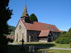
The parish church, St Garmon's, was begun in Norman times and retains many original features. [10] It is a Grade II* listed building. [11] Consisting of a single chamber, it has Romanesque windows in the east wall and two doorways in the south wall. There were some Victorian alterations, including the addition of a western bell turret. Inside, the roof dates from the 15th century, the font dates from about 1500, the pulpit bears a date of 1636, and at the western end its gallery remains. [7]

Little is known of St Garmon. Tradition has him living in the 9th century and preaching from a mound in Llanfechain churchyard. The remains of the mound, Twmpath Garmon, are still evident north of the church, although graves have been dug into it. According to the recollections of 19th-century villagers recorded in Volume 5 of the Montgomeryshire Collections, cockpits were dug near to the mound for cockfighting. Fynnon Garmon, the holy well associated with Garmon, lies to the south-east of the village. [12] St Garmon is likely to have been derived from St Germanus (410–474), the first Bishop of Man. [8]

The village once had two chapels: the Peniel Wesleyan Methodist Chapel (erected 1834, rebuilt 1875, Sunday School added 1901, closed about 1990, now residential), [13] and Zoar Calvinistic Methodist Chapel (erected 1827, rebuilt 1914, [14] closed 2008). [15] [16]

Notable sites and buildings

Notable residents

In order of birth date:

Railway

Llanfechain was served by a station on the Llanfyllin branch of the Cambrian Railways from 1863. The line closed in 1965 and has since been dismantled. [33] The station building remains as a private residence. The track bed to Llanfyllin has been built over by an industrial estate.

Education and amenities

The village has a small Church in Wales primary school. It was rated Good in a May 2016 Estyn report. [34] [35]

The village has a village hall. A traditional village show had been held on the August Bank Holiday weekend every year since 1966, [36] but had to be cancelled in 2020 due to the COVID-19 pandemic. [37]

Related Research Articles

<span class="mw-page-title-main">Llanrhaeadr-ym-Mochnant</span> Human settlement in Wales

Llanrhaeadr-ym-Mochnant is a village and community in Powys, Wales; about 9 miles west of Oswestry and 12 miles south of Llangollen, on the B4580. It lies near the foothills of the Berwyn mountains on the river Rhaeadr. At the top end of the valley is the Pistyll Rhaeadr waterfall, one of the Seven Wonders of Wales in the old rhyme. One mile north of the town is the hill Moel Hen-fache. The community includes the hamlet of Llanarmon Mynydd Mawr.

<span class="mw-page-title-main">Meifod</span> Human settlement in Wales

Meifod, formerly also written Meivod, is a small village, community and electoral ward seven miles (11 km) north-west of Welshpool in Montgomeryshire, Powys, Wales, on the A495 road and located in the valley of the River Vyrnwy. The River Banwy has a confluence with the Vyrnwy approximately two miles (3.2 km) to the west of the village. The village itself had a population of 317. The community includes the village of Bwlch-y-cibau and the hamlet of Allt-y-Main.

<span class="mw-page-title-main">Diocese of St Asaph</span> Diocese of the Church in Wales

The Diocese of Saint Asaph is a diocese of the Church in Wales in north-east Wales, named after Saint Asaph, its second bishop.

<span class="mw-page-title-main">Llandinam</span> Human settlement in Wales

Llandinam is a village and community in Montgomeryshire, Powys, central Wales, between Newtown and Llanidloes, located on the A470. As a community, Llandinam is made up of the village itself, small hamlets including Plas Dinam and Little London and several farms. The village itself has a population of around 576 with 56% born in Wales.

<span class="mw-page-title-main">Llansantffraid-ym-Mechain</span> Human settlement in Wales

Llansantffraid-ym-Mechain is a large village in the community of Llansantffraid, in Powys, Mid Wales. It is close to the border with Shropshire in England, about 7 miles (11 km) south-west of Oswestry and 8 miles (13 km) north of Welshpool. It is on the A495 road and is at the confluence of the River Vyrnwy and the River Cain. The population as of the 2011 UK census was 1,415. The community includes the village of Deuddwr and several hamlets.

<span class="mw-page-title-main">Llanfyllin</span> Human settlement in Wales

Llanfyllin is a market town and community in Powys, Wales. The community population in 2021 was 1,586 and the town's name means church or parish (llan) of St Myllin. The community includes the settlements of Bodfach, Ty Crwyn, Abernaint and several farms.

The Battle of Mechain was fought in Powys, Wales, in 1070, for rule of the Welsh kingdoms of Gwynedd and Powys. The battlefield may be near Llanfechain in northern Powys. A written account is included in the Brut y Tywysogion, the medieval Welsh chronicle of the princes. It is also referred to in the work of medieval poets such as Lewys Glyn Cothi.

<span class="mw-page-title-main">Mechain</span> Welsh medieval cantref

Mechain was a medieval cantref in the Kingdom of Powys. This cantref has also been referred to as Y Fyrnwy (Vyrnwy). Mechain may owe its name to the River Cain which flows through it on its way to join the River Vyrnwy; 'Me' or 'Mach' may signify meadows or plain, in which case Mechain would mean "Meadows of the Cain". It corresponds to the later hundred of Llanfyllin.

<span class="mw-page-title-main">St Garmon's Church, Llanfechain</span> Church in Powys, Wales

St Garmon's Church, Llanfechain, is in the village of Llanfechain, Powys, Wales. It is an active Anglican parish church in the deanery of Llanfyllin, the archdeaconry of Montgomery, and the diocese of St Asaph, and is designated by Cadw as a Grade II* listed building. The church is traditionally associated with a 9th-century Celtic saint, St Garmon. St Garmon was most likely St Germanus (410–474), the first Bishop of Man. It shares it name with the church in the village of St Harmon in Radnorshire (Powys), where the diarist Francis Kilvert was a curate.

<span class="mw-page-title-main">Llandyssil</span> Village in Powys, Wales

Llandyssil is a village in the community of Abermule with Llandyssil, in Powys, Wales, in the traditional county of Montgomeryshire. It is about two miles from the town of Montgomery.

<span class="mw-page-title-main">Bro Garmon</span> Community in Conwy County Borough, Wales

Bro Garmon is a community in Conwy County Borough, in Wales. It is located on the eastern side of the Conwy Valley, stretching from north east of Llanrwst to just west of Pentrefoelas, and includes the villages of Capel Garmon, Glan Conwy, Melin-y-Coed, Nebo, Oaklands, Rhydlanfair and Pentre-tafarn-y-fedw. Moel Seisiog, on the eastern boundary, rises to a height of 1,535 feet (468 m). The main settlement, Capel Garmon, lies 2.4 miles (3.9 km) east of Betws-y-Coed, 5.2 miles (8.4 km) north west of Pentrefoelas, 4.4 miles (7.1 km) south of Llanrwst and 15.7 miles (25.3 km) south of Conwy. At the 2001 census the community had a population of 648, increasing slightly at the 2011 census to 652.

<span class="mw-page-title-main">Penderyn, Rhondda Cynon Taf</span> Village in Rhondda Cynon Taf, Wales

Penderyn is a rural village in the Cynon Valley, Rhondda Cynon Taf, Wales, located near Hirwaun.

<span class="mw-page-title-main">Castle Caereinion</span> Village and community in Powys, Wales

Castle Caereinion is a small village and community in Montgomeryshire, Powys, Wales, upon the River Banwy, around 8 miles west of Welshpool, and 4 miles east of Llanfair Caereinion.

<span class="mw-page-title-main">Penstrowed</span> Human settlement in Wales

Penstrowed is a historic Montgomeryshire parish to the west of Newtown, now in the community of Mochdre with Penstrowed, Powys, Wales.

<span class="mw-page-title-main">Tomen yr Allt</span>

Tomen yr Allt was a Medieval motte and bailey defensive castle near Llanfyllin in Powys, Wales. "Tomen ar hallt" is modern Welsh for "mound on the wooded hillside."

<span class="mw-page-title-main">River Cain</span> River in north Powys, Wales

The River Cain is a river in north Powys which flows into the River Vyrnwy.

<span class="mw-page-title-main">Registered historic parks and gardens in Powys</span> List of buildings in county of Wales

Powys is a county and preserved county in Wales. It covers an area of 5,180 km2 (2,000 sq mi) and in 2021 the population was approximately 133,600.

<span class="mw-page-title-main">Registered historic parks and gardens in Conwy County Borough</span> List of buildings in county borough of Wales

Conwy County Borough is a county borough in the north of Wales. It covers an area of 1,126 km2 (435 sq mi) and had a population of approximately 114,800 in 2021.

<span class="mw-page-title-main">St Cynhafal's Church, Llangynhafal</span> Church in Denbighshire, Wales

St Cynhafal's Church is a small, isolated church east of the scattered village of Llangynhafal in Denbighshire, Wales. Its only immediate neighbour is the former rectory, Plas-yn-llan, birthplace of the Rev. Robert Jones, friend of William Wordsworth and where Wordsworth stayed in the 1790s. The church is dedicated to Saint Cynhafal, a 7th-century monk, and is the only such dedication in the United Kingdom. Although with earlier origins, the present church dates to the 13th century, and was largely rebuilt in the 15th. It remains an active church in the Diocese of St Asaph and is a Grade I listed building.

References

  1. "Community population 2011". Neighbourhood Statistics. Office for National Statistics . Retrieved 13 November 2015.
  2. City Population. Retrieved 18 January 2021.
  3. "Mechain, Possible site of Battle, near Llanfechan (sic) (405112)". Coflein. RCAHMW . Retrieved 31 May 2023.
  4. Lloyd, John Edward (1912). A History of Wales from the Earliest Times to the Edwardian Conquest. Longmans, Green, and Co. p. 247. Retrieved 16 April 2015.
  5. Cathrall, William (1828). The History of North Wales Volume II. Manchester. p. 345.
  6. Richards, Robert (1949). "Y domen Gastell". Montgomeryshire Collections Relating to Montgomeryshire and Its Borders. 51: 72. Retrieved 15 April 2015.
  7. 1 2 3 4 5 6 "Historic Settlement Survey – Montgomeryshire – Llanfechain" (PDF). Clwyd Powys Archaeological Trust. Retrieved 23 March 2015.
  8. 1 2 Baring-Gould, Sabine; Fisher, John. The Lives of the British Saints Volume 3. p. 77.
  9. Room, Adrian (2010). Dictionary of Pseudonyms: 13,000 Assumed Names and Their Origins, 5th ed. McFarland. p. 214.
  10. "Church of St Garmon, Llanfechain". Montgomeryshire Churches Survey. Retrieved 5 May 2008.
  11. "Church of St. Garmon, Llanfechain". British Listed Buildings. Retrieved 14 December 2013.
  12. 1 2 "Trail Two – The Cain Valley Trail – St Garmon, Llanfechain" (PDF). April 2009. Retrieved 23 March 2015.
  13. "PENUEL METHODIST CHAPEL (WESLEYAN), LLANFECHAIN (11348)". Coflein. RCAHMW . Retrieved 26 March 2015.
  14. "LLANFECHAIN CHAPEL (WELSH CALVINISTIC METHODIST;SOAR), LLANFECHAIN (11347)". Coflein. RCAHMW . Retrieved 26 March 2015.
  15. "The Churches of Britain and Ireland". The Churches of Britain and Ireland. Retrieved 26 March 2015.
  16. "Llanfechain: Church History". Genuki. Retrieved 26 March 2015.
  17. 1 2 An Inventory of the Ancient Monuments in Wales and Monmouthshire: I - County of Montgomery. Royal Commission on the Ancient and Historical Monuments of Wales. 1913. p. 89.
  18. "Llanfechain". Visitor UK. Retrieved 26 March 2015.
  19. "Ty-coch, Llanfechain". British Listed Buildings. Retrieved 26 March 2015.
  20. 1 2 "Llanfechain". Visitor UK. Retrieved 14 April 2015.
  21. "Plas Cain, Llanfechain". British Listed Buildings.
  22. "Old Rectory, Llanfechain". British Listed Buildings. Retrieved 26 March 2015.
  23. "Bodynfoel Hall". Parks and Gardens UK. Retrieved 23 March 2015.
  24. "Bodynfoel Hall". British Listed Buildings. Retrieved 23 March 2015.
  25. "BODYNFOEL HALL, GARDEN, LLANFECHAIN (86672)". Coflein. RCAHMW . Retrieved 26 March 2015.
  26. Cadw. "Bodynfoel Hall (PGW(Po)42(POW))". National Historic Assets of Wales. Retrieved 6 February 2023.
  27. Koch, John T (2006). Celtic Culture: Aberdeen breviary-celticism. ABC-CLIO. p. 862. ISBN   9781851094400.
  28. Lewis, Samuel (1833). A Topographical Dictionary of Wales.
  29. "Walter Davies ('Gwallter Mechain') and The Board of Agriculture". The National Library of Wales . Retrieved 5 May 2008.
  30. "Thomas, David (1880–1967), educationalist, author and Labour Party pioneer in north Wales". Dictionary of Welsh Biography . Retrieved 11 September 2019.
  31. Fordham, pp. 203–204.
  32. Chris Gostick, "Extra Material on James Hanley's The Closed Harbour". The Closed Harbour. (Richmond, Surrey: Oneworld Classics, 2009), p. 213.
  33. "Victorian Llanfechain". Victorian Powys for Schools. Retrieved 5 May 2008.
  34. Report text.
  35. School site. Retrieved 19 January 2021.
  36. "Llanfechain Village Show" . Retrieved 5 May 2008.
  37. Show page. Retrieved 19 January 2021.