Beacons Reservoir

Last updated

Beacons Reservoir
Beacons Reservoir Snowy.jpg
Powys UK relief location map.jpg
Red pog.svg
Beacons Reservoir
Location Taff Fawr valley, South Wales
Coordinates 51°51′23″N3°28′19″W / 51.85639°N 3.47194°W / 51.85639; -3.47194
Type reservoir
Basin  countriesUnited Kingdom

Beacons Reservoir (Welsh : Cronfa'r Bannau) is the northernmost of the three reservoirs in the Taff Fawr valley in South Wales. It was built by Cardiff Corporation Waterworks between 1893 and 1897, and the water is impounded by an earth dam with a clay core. Since 1973 it has been owned by Welsh Water. [1] As its name suggests, it is located in the Brecon Beacons National Park in the Powys unitary authority area and within the historic county boundaries of Breconshire.

Contents

There is access to the Taff Trail from the car park below the dam.

History

Cardiff Corporation had bought out the Cardiff Waterworks Company in 1879, [2] and in March 1881 asked their Borough Engineer, John Avery Brandon Williams, to produce a report on all possible sources of water for Cardiff, so that they could plan for the future. Williams presented his reports in May and August 1881, suggesting that the best scheme was to impound the waters of the upper Taff Fawr. After consulting the water engineer John Frederick Bateman, who also recommended the Taff Fawr scheme in June 1882 as the one most likely to meet the needs for water at the lowest cost, [3] the Corporation presented a bill to Parliament in November 1883, which was considered by a House of Commons Committee between 1 May and 20 May 1884. It faced serious opposition from riparian landowners and there were 16 petitions against it, but several influential civil engineers was called to give evidence, notably Bateman, Thomas Hawksley James Mansergh, and George H. Hill. J A B Williams, their own Engineer, and the meteorologist George James Symonds also gave evidence, and although it cost the Corporation £3,652 to fight the case, Royal Assent was obtained for the Cardiff Corporation Act 1884 on 7 August. [4]

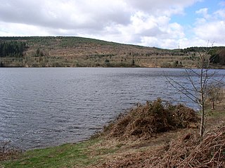
The catchment of the upper Taff Fawr was 10,400 acres (42 km2) but it was split into an upper area of 4,000 acres (16 km2) and a lower one of 6,400 acres (26 km2). Any works had to provide compensation water to maintain the flow in the Taff Fawr, and working on the upper area first meant that they only had to supply 3 million imperial gallons (14 Ml) per day of compensation flow until work started on the lower area. Cantref Reservoir, at the time known as Cantreff, was the first to be built, together with a 32-mile (51 km) pipeline to Lisvane Reservoir and Llanishen Reservoir and intermediate balancing reservoirs at Blackbrook, Cefn, and Rhubina. Work on the pipeline was completed in September 1888, and on the balancing reservoirs in November 1888. [5] Cantref Reservoir was completed on 14 September 1892, and attention then turned to the highest reservoir in the chain. [6]

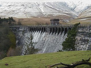
The 1884 Act had specified that the Beacons Reservoir would have a capacity of 160 million imperial gallons (730 Ml) [7] but during the detailed planning for the project, Williams found that placing the dam a little higher up the valley would more than double the capacity of the reservoir, and would also provide a solid rock foundation on which to build it. Accordingly, the Corporation went back to Parliament, and the Cardiff Corporation Act 1894 authorised the expanded reservoir, [8] which would have a capacity of 345 million imperial gallons (1,570 Ml). For Cantref Reservoir, a standard gauge railway had been constructed from the main line at Cefn-coed-y-cymmer to the dam site, some 6 miles (9.7 km) to the north. [7] They had started to extend it towards the Beacons site in 1891, and had agreed terms with the landowner, Sir William Lewis, for the existing railway to remain in place for another six years, but in March 1892 a disagreement occurred, and 1.14 miles (1.83 km) of track were lifted where the railway crossed his land. Most of the extension to Beacons passed through land owned by Lord Tredegar, with whom separate negotiations were taking place. The differences were resolved, and after the Board of Trade approved the new route on 27 April 1893, the lifted track was re-instated, and the track to Beacons was completed, making a 7.25-mile (11.67 km) railway. Some difficulties had been experienced building the Cantref dam, with two contractors failing to complete the work, which had resulted in the Corporation completing the job by using direct labour. For Beacons, they decided to use direct labour for the whole project, [9] and work began in April 1893, in advance of obtaining the Act of Parliament. [8]

The site was remote, and situated around 1,300 to 1,400 feet (400 to 430 m) Above Ordnance Datum. By the auturm of 1893, a whole village had been created near the dam site, with sidings and running roads on the railway, workshops for carpenters, a blacksmith's workshop, a boiler house, a fitting shop, a shed for the locomotives, a saw mill, stables for the horses, a wagon shop and accommodation for 335 men. Where possible, buildings had been removed from Cantref and reused, although living quarters for another 85 men remained at Cantref. One unusual item purchased at the time was 500 yards (460 m) of 15 in (381 mm)-gauge "Decauville railway", complete with turntables, points and wagons, but its use was never recorded. [9] As with Cantref, stone was obtained from a quarry near Cefn-coed-y-cymmer, close to the private railway, and puddle clay for the central core of the dam was extracted from a field which was part of the Crawshay Brothers ironworks at Cyfarthfa, where a 3 ft (914 mm)-gauge railway was used to transport the clay to the mainline railway. [10]

The busiest period was in 1895–96, when some 500 men were employed. While many were involved in building the dam, others worked on the railway, in the quarry, and at the clay field at Cyfarthfa. February 1896 was the busiest month, when 4,100 tons of clay were excavated and transferred to the dam site. There were periods where wet weather meant that men did not work on the main construction, and in some cases were laid off until the weather improved. From September 1895, the workmen's train was withdrawn, and despite petitions from the men, the Committee refused to reverse their decision. By Christmas 1896, the main core of the dam was completed, and finishing works were carried on through the spring and summer. The railway yard at Beacons, and the track to below the Cantref dam were removed between March and June 1897, impounding of water began on 17 September, while many of the buildings were dismantled prior to the opening ceremony held on 30 September, when Alderman David Jones presided. [11]

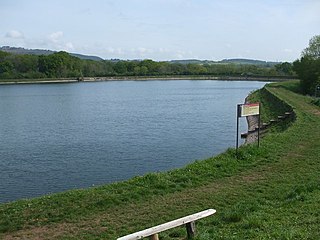
The dam consists of an earth embankment with a clay core, which is faced with masonry. A circular valve tower with castellated stonework is located on a masonry platform which projects from the inner face of the dam. The valve tower is offset towards the east side of the dam, and there is a spillway at its eastern edge, crossed by a stone bridge. The length of the dam is 1,020 feet (310 m) and it is 61 feet (18.6 m) tall at its highest point. [12]

Archaeological sites

During periods of low water, the remains of longhouses can be seen. One building overlooking the Taff Fawr has foundations of massive weathered slabs. Flint tools have been found.

Bibliography

Related Research Articles

<span class="mw-page-title-main">Brecon Beacons</span> Region and national park in south Wales

Bannau Brycheiniog, formerly known as Brecon Beacons, is a mountainous region and national park in Wales. The name 'Brecon Beacons' was originally applied only to the mountain range south of Brecon, Powys, which is now also known as the Central Beacons. The range includes South Wales' highest mountain, Pen y Fan, its twin summit Corn Du, and Craig Gwaun Taf, which are the three highest peaks in the range.

<span class="mw-page-title-main">Brecknockshire</span> Historic county of Wales

Brecknockshire, also known as the County of Brecknock, Breconshire, or the County of Brecon is one of thirteen historic counties of Wales, and a former administrative county. Named after its county town of Brecon, the county is mountainous and primarily rural.

<span class="mw-page-title-main">Elan Valley Reservoirs</span> Reservoirs in Elan Valley in Powys, Wales

The Elan Valley Reservoirs are a chain of man-made lakes created from damming the Elan and Claerwen rivers within the Elan Valley in Mid Wales. The reservoirs, which were built by the Birmingham Corporation Water Department, provide clean drinking water for Birmingham in the West Midlands of England. The five lakes are known as the Claerwen, Craig-goch, Pen-y-garreg, Garreg-ddu, and Caban-coch.

<span class="mw-page-title-main">Porth</span> Human settlement in Wales

Porth is a town and a community in the county borough of Rhondda Cynon Taf, within the historic county boundaries of Glamorgan, Wales. Lying in the Rhondda Valley, it is regarded as the gateway connecting the Rhondda Fawr and Rhondda Fach valleys due to both valleys meeting at Porth. The Welsh word "porth" means "gate". Porth is a predominantly English-speaking community.

<span class="mw-page-title-main">Taff Trail</span> Walking and cycling track in South Wales

The Taff Trail is a popular walking and cycle path that runs for 55 miles (89 km) between Cardiff Bay and Brecon in Wales. It is so named because it follows the course of the River Taff. Along much of its length, it follows the National Cycle Network Route 8 that continues to Holyhead, and is substantially off-road.

<span class="mw-page-title-main">River Taff</span> River in Wales which flows into Cardiff Bay

The River Taff is a river in Wales. It rises as two rivers in the Brecon Beacons; the Taf Fechan and the Taf Fawr before becoming one just north of Merthyr Tydfil. Its confluence with the River Severn estuary is in Cardiff.

<span class="mw-page-title-main">Dinas Rhondda</span> Human settlement in Wales

Dinas is a village near Tonypandy in the county borough of Rhondda Cynon Taf, Wales. Dinas is often referred to as Dinas Rhondda to avoid confusion with Dinas Powys in the Vale of Glamorgan. The word dinas in Modern Welsh means "city", but here it means "hill fort".

<span class="mw-page-title-main">High Bullough Reservoir</span> Reservoir in Lancashire, England

High Bullough Reservoir is the oldest of all the reservoirs in the Rivington chain, having been authorised by an Act of Parliament obtained in 1846 and completed in 1850. It was built for Chorley Waterworks by the engineer John Frederick Bateman, who had estimated the cost of the project while working for Edwin Chadwick's Towns Improvement Company, and had then acted as Engineer for the project. The outlet consisted of a pipe running through the dam, and supported by two masonry piers where it ran through the central clay puddle. The outlet valve was at the downstream end of the dam, and although this configuration is no longer thought to be good practice, there have been no serious issues with the reservoir throughout its operational life. The earth dam had a maximum height of 39 feet (12 m), was 988 feet (301 m) long and impounded 55 million imperial gallons (250 Ml) of water.

<span class="mw-page-title-main">Cantref Reservoir</span> Reservoir in Wales

Cantref Reservoir is the middle of the three reservoirs in the Taff Fawr valley in Wales. It was built by Cardiff Corporation Waterworks between 1886 and 1892, but since 1973 has been owned by Welsh Water. It is located in the Brecon Beacons National Park, mostly in the Powys unitary authority area and within the historic county boundaries of Breconshire. Part of the south west corner is in the Rhondda Cynon Taff unitary authority area.

<span class="mw-page-title-main">Llwyn-on Reservoir</span> Reservoir in South Wales

Llwyn-on Reservoir is the largest and southernmost of the three reservoirs in the Taf Fawr valley in South Wales. Cardiff Corporation Waterworks obtained an Act of Parliament in 1884 to authorise construction of the reservoirs, to increase the water supply for Cardiff, but construction of Llwyn-on Reservoir did not start until 1911 and was completed in the 1920s.

Upper Roddlesworth Reservoir is a reservoir on the River Roddlesworth near Abbey Village in Lancashire, England.

<span class="mw-page-title-main">Fan Fawr</span> Mountain (734m) in Powys, Wales

Fan Fawr is a mountain in the Fforest Fawr section of the Brecon Beacons National Park, in Powys, Wales and over 734 m (2,408 ft) high.

<span class="mw-page-title-main">Llanishen Reservoir</span> Victorian reservoir in north Cardiff, Wales

Llanishen Reservoir is a Victorian reservoir in north Cardiff, Wales. The reservoir is one of the reservoirs constructed as part of the Taff Fawr scheme for supplying water to Cardiff and was completed in 1886. It forms part of the Nant Fawr Corridor from the top of Roath Park to the countryside beyond Cyncoed.

<span class="mw-page-title-main">Ystradfellte Reservoir</span> Reservoir in Wales

Ystradfellte Reservoir is a water storage reservoir on the Afon Dringarth in the upland area of Fforest Fawr within the Brecon Beacons National Park in South Wales. It lies just north of the village of Ystradfellte in the county of Powys at OS Grid ref SN 946178.

<span class="mw-page-title-main">Pontsticill Reservoir</span> Reservoir in Merthyr Tydfil, Wales

Pontsticill Reservoir or Taf Fechan Reservoir is a large reservoir on the Taf Fechan lying partly in the county of Powys and partly within the county borough of Merthyr Tydfil in south Wales. It lies within the Brecon Beacons National Park and Fforest Fawr Geopark.

<span class="mw-page-title-main">Nidd Valley Light Railway</span> Disused railway in Yorkshire, England

Nidd Valley Light Railway was a light railway in upper Nidderdale in the West Riding of Yorkshire, England. It was owned by Bradford Corporation Waterworks Department and the corporation also operated its public passenger services. Power & Traction Ltd of London obtained a Light Railway Order for the 6.5-mile (10.5 km) railway from Pateley Bridge to Lofthouse in 1900, but these powers were taken over by Bradford Corporation. A contract to build Angram Reservoir was awarded to John Best & Son in 1903, and he also won the contract to build the public railway and a 6.5-mile (10.5 km) private extension to the reservoir site. This was initially built to 3 ft gauge but was converted to standard gauge by 1907, when the public railway opened. Best had his own locomotives, and Bradford Corporation equipped the public railway with second hand locomotives and carriages from the Metropolitan Railway.

<span class="mw-page-title-main">Cefn-coed-y-cymmer</span> Historic site

Cefn-coed-y-cymmer is a small community on the northwestern edge of Merthyr Tydfil County Borough in Wales. It is situated in the neck of land between the rivers Taf Fawr and Taf Fechan at their confluence. The village lies within the community of Vaynor. Immediately to the north of the village is the hill of Cefn Cil Sanws on the southern slopes of which is Merthyr Tydfil Golf Club. The village is bounded both to the north and the west by the Brecon Beacons National Park.

<span class="mw-page-title-main">Grwyne Fawr Reservoir</span> Reservoir in Brecon Beacons, Wales

The Grwyne Fawr Reservoir is located in the valley of the river Grwyne Fawr in the Brecon Beacons National Park, Wales. Completed in 1928, it has the capacity to hold 400,000,000 imperial gallons.

<span class="mw-page-title-main">Cardiff Corporation Waterworks</span> Defunct UK water and sewerage provider

Cardiff Corporation Waterworks, its predecessors and successors have provided a public water supply and sewerage and sewage treatment services to the Welsh city of Cardiff since 1850.

<span class="mw-page-title-main">Upper Barden Reservoir</span> Freshwater reservoir in North Yorkshire, England

Upper Barden Reservoir is an upland fresh water reservoir, one of two reservoirs that collect water from Barden Moor, and dam Barden Beck, a tributary of the River Wharfe in the Yorkshire Dales, North Yorkshire, England. The reservoir was opened in 1882 and also supplies fresh water to the Nidd Aqueduct, which transports it to Bradford. Upper Barden Reservoir was the second of the reservoirs to be built,.

References

  1. "A Guide To Recreation Around The Reservoirs Of Wales" (PDF). Welsh Water. p. 10. Retrieved 5 January 2015.
  2. Wheatley 1905, p. 459.
  3. Wheatley 1905, pp. 461–462.
  4. Wheatley 1905, pp. 462–463.
  5. Wheatley 1905, p. 463.
  6. Bowtell & Hill 2006, p. 10.
  7. 1 2 Bowtell & Hill 2006, p. 9.
  8. 1 2 Wheatley 1905, p. 464.
  9. 1 2 Bowtell & Hill 2006, p. 13.
  10. Bowtell & Hill 2006, pp. 10–11.
  11. Bowtell & Hill 2006, pp. 13–14.
  12. Timelines 2020.