
The River Usk rises on the northern slopes of the Black Mountain, Wales, in the westernmost part of the Brecon Beacons National Park. Initially forming the boundary between Carmarthenshire and Powys, it flows north into Usk Reservoir, then east by Sennybridge to Brecon before turning southeast to flow by Talybont-on-Usk, Crickhowell and Abergavenny, after which it takes a more southerly course.

Brecknockshire, also known as the County of Brecknock, Breconshire, or the County of Brecon, was one of the thirteen historic counties of Wales. It was created in 1536 under the Laws in Wales Act 1535. From 1889 it was an administrative county with a county council; the administrative county was abolished in 1974. The county was named after the medieval Welsh territory of Brycheiniog, which was anglicised to "Brecknock" and also gave its name to the county town of Brecon. The county was mountainous and primarily rural.

Crickhowell is a town and community in southeastern Powys, Wales, near Abergavenny, and is in the historic county of Brecknockshire.

The Black Mountains are a group of hills spread across parts of Powys and Monmouthshire in southeast Wales, and extending across the England–Wales border into Herefordshire. They are the easternmost of the four ranges of hills that comprise the Brecon Beacons national park, and are frequently confused with the westernmost, which is known as the Black Mountain. The Black Mountains may be roughly defined as those hills contained within a triangle defined by the towns of Abergavenny in the southeast, Hay-on-Wye in the north and the village of Llangors in the west. Other gateway towns to the Black Mountains include Talgarth and Crickhowell. The range of hills is well known to walkers and ramblers for the ease of access and views from the many ridge trails, such as that on the Black Hill in Herefordshire, at the eastern edge of the massif. The range includes the highest public road in Wales at Gospel Pass, and the highest point in southern England at Black Mountain.

Bwlch is a small village and an electoral ward in the community of Cwmdu and District, Powys, south Wales. The settlement is strung out along the A40 road which crosses a low col above the Usk Valley at this point on its route between Brecon and Crickhowell.
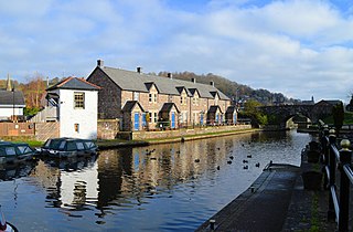
The Monmouthshire and Brecon Canal is a small network of canals in South Wales. For most of its currently (2018) navigable 35-mile (56 km) length it runs through the Brecon Beacons National Park, and its present rural character and tranquillity belies its original purpose as an industrial corridor for coal and iron, which were brought to the canal by a network of tramways and/or railroads, many of which were built and owned by the canal company.
Talybont-on-Usk is a village and community in Powys, Wales, in the historic county of Brecknockshire. It lies on both the Caerfanell river and the Monmouthshire and Brecon Canal, about 1 mile (1.6 km) from the River Usk. In 2001, it had a population of 743, reducing to 719 at the 2011 census. The community includes the settlements of Llansantffraed, Scethrog, Aber Village, and Pencelli.

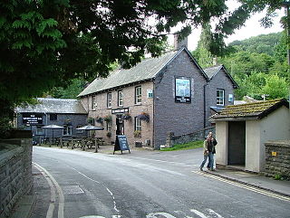
Gilwern is a village within the Brecon Beacons National Park in Monmouthshire, Wales. Historically in Brecknockshire, it extends to either side of the River Clydach on the south side of the Usk valley. Its position beside the Monmouthshire and Brecon Canal led to it being an important industrial centre at one time.

Govilon is a small Welsh village located between Llanfoist and Gilwern near Abergavenny in north Monmouthshire. It is part of the community of Llanfoist Fawr. The population was 1,447 in 2011.
The Usk Valley Walk is a waymarked long distance footpath in south east Wales, from Caerleon to Brecon.

The Beacons Way is a waymarked long distance footpath in the Brecon Beacons National Park, Wales. It is a linear route which runs for 99 miles (159 km) east to west through the National Park, and passes many of the most important landmarks and mountain peaks in the mountain range. It also includes a few of the towns in the park as well as popular attractions such as Carreg Cennen Castle near Llandeilo at the western end of the path.

Mynydd Llangatwg or Llangattock Mountain is a hill in the Brecon Beacons National Park mostly in the county of Powys, south Wales but also extending into both Monmouthshire and Blaenau Gwent. It is named from the village of Llangatwg which sits in the valley of the River Usk to the north of it. It is essentially an undulating plateau rising in the west to a height of 530 metres (1,740 ft) at grid reference SO171157 and in the east to a height of 529 metres (1,736 ft) at Hen Dy-aderyn / Twr Pen-cyrn. This latter spot is marked by a trig point. The shallow pool of Pwll Gwy-rhoc sits in a broad depression towards the northern edge of the plateau whilst a smaller pool frequently occupies a large shakehole a few hundred metres to its west. The hill forms an impressive northern scarp overlooking the Usk valley and commonly referred to as the Llangattock Escarpment. Its southern margins are more subdued. Its eastern end is defined by the drops into the Clydach Gorge. Beyond the B4560 to the west the hill merges with Mynydd Llangynidr which has a similar character.
Mynydd Llangynidr is a mountain in the Brecon Beacons National Park largely in the county of Powys, south Wales. Its southern slopes extend into the northernmost parts of the county borough of Blaenau Gwent. It is named from the village of Llangynidr which sits in the valley of the River Usk to the north of it. It is essentially an undulating plateau rising in the west to a height of 557m at Garn Fawr at OS grid ref SO 123151. A secondary high point is achieved at a point marked by a trig point at SO 147159. To the north the hill overlooks the valleys of Dyffryn Crawnon and Cwm Claisfer, themselves tributary valleys of the Usk. The shallow upper valley of the Ebbw River reaches into the plateau in the southeast whilst the upper reaches of the Sirhowy Valley and its tributary the Nant Trefil define its western margins. A further tributary, the Nant Milgatw, reaches in from the south whilst the sharp edge of Rassau Industrial Estate also defines a part of its southern margin. Passing east across the B4560, the hill merges with Mynydd Llangatwg which has a similar character.

Trefil is a small village in the county borough of Blaenau Gwent, south Wales. It lies at the top of the Sirhowy Valley, near to Brecon Beacons National Park. It is three miles northwest of Tredegar. With one public house, The Top House, serving homemade food and drinks to local visitors.

Llangattock is a village, community and electoral ward in the Brecon Beacons National Park in Powys, Wales. It lies in the Usk Valley just across the river from the town of Crickhowell. The Monmouthshire and Brecon Canal passes through the village en route between Brecon and Pontypool. It is in the historic county of Breconshire.
Tretower is a hamlet in the community of Cwmdu and District, in the southern part of the county of Powys in Wales. It lies on the A479 road within the Brecon Beacons National Park at the foot of the Black Mountains just off the Usk Valley. Tretower is frequented by tourists visiting the impressive Tretower Court and the nearby ruins of Tretower Castle, both of which are now managed by Cadw. Cadw own the Court whilst ownership of the Castle lies with the owner of Tyllys Farm in the centre of the village.

Llanfrynach is a village and community in the county of Powys, Wales, and the historic county of Brecknockshire. The population of the community as taken at the 2011 census was 571. It lies just to the southeast of Brecon in the Brecon Beacons National Park. The village sits astride the Nant Menasgin, a right bank tributary of the River Usk. The B4558 passes just to its north and the Monmouthshire and Brecon Canal also passes around the village. The Welsh name signifies the 'church of Brynach'. The community includes the hamlets of Llanhamlach and Groesffordd.
The B4558 road is a road in Powys, central Wales, with a total length of 12 miles (19 km). It begins at a junction with the A4077 road across the Usk bridge from Crickhowell and runs northwest up the southern side of the Usk valley to a junction with the A40 road 3.5 km east of Brecon. En route from Crickhowell it passes through the villages of Llangynidr, Talybont-on-Usk, and Pencelli. It is closely followed over this section by the Monmouthshire and Brecon Canal which it crosses six times. River crossings include those of the Nant Cleisfer and Afon Crawnon at Llangynidr, the Caerfanell at Talybont and the Nant Menasgin between Pencelli and Llanfrynach. It crosses the Usk itself by the historic Lock Bridge just south of the village of Groesffordd, east of Brecon.
Pencelli is a small village within the community of Talybont-on-Usk in the county of Powys, Wales, and the historic county of Brecknockshire. The Welsh name signifies the 'end of (a) grove'. It lies just to the southeast of Brecon in the Brecon Beacons National Park. The village sits near the confluence of the Nant Menasgin with the River Usk. Both the B4558 and the Monmouthshire and Brecon Canal pass through the village. There is a pub - the Royal Oak, an outdoor education centre and a campsite within the village. Pencelli Castle is likely a late eleventh century fortification which fell into disuse in the thirteenth century.
Groesffordd is a small village within the community of Llanfrynach in the county of Powys, Wales, and the historic county of Brecknockshire. The Welsh name signifies the 'crossroads'. It lies just to the east of Brecon straddling the northern boundary of the Brecon Beacons National Park. The village sits just to the north of the A40 road between Brecon and Crickhowell and north of the River Usk and Monmouthshire and Brecon Canal. The track of the former Brecon and Merthyr Railway runs through the village


