
Church Stretton is a market town in Shropshire, England, 13 miles (21 km) south of Shrewsbury and 15 miles (24 km) north of Ludlow. The population in 2011 was 4,671.

Draperstown is a village in the Sperrin Mountains in County Londonderry, Northern Ireland. It is situated in the civil parish of Ballinascreen and is part of Mid-Ulster district. It is also part of the Church of Ireland parish of Ballynascreen and the Catholic parish of Ballinascreen, and within the former barony of Loughinsholin.

March is a Fenland market town and civil parish in the Isle of Ely area of Cambridgeshire, England. It was the county town of the Isle of Ely which was a separate administrative county from 1889 to 1965. The administrative centre of Fenland District Council is located in the town.

Blanchardstown is a large outer suburb of Dublin in the modern county of Fingal, Ireland. Located ten km (6.2 mi) north-west of the Dublin city centre, it has developed since the 1960s from a small village to a point where Greater Blanchardstown is the largest urban area in Fingal.

Broughton Gifford is a village and civil parish about 1.5 miles (2.4 km) west of Melksham in Wiltshire, England. The parish includes the hamlets of Norrington Common and The Common.

Donhead St Mary is a village and civil parish in southwest Wiltshire, England, on the county border with Dorset. The village lies about 2+1⁄2 miles (4.0 km) east of the Dorset town of Shaftesbury and stands on high ground above the River Nadder, which rises in the parish.

Homersfield, also known as St Mary, South Elmham, is a village and civil parish in the north of the English county of Suffolk. It is in the East Suffolk district, 4 miles (6.4 km) south-west of the market town of Bungay and 3 miles (4.8 km) north-east of Harleston. The official name of the civil parish is St Mary, South Elmham otherwise Homersfield. It is one of the parishes around Bungay known as The Saints.

St Harmon is a village in Radnorshire, Powys, Wales. The population of the community at the 2011 census was 593. It is located on the Afon Marteg on the B4518 road running between Llanidloes and Rhayader. The parish church is called Saint Garmon,(Germanus of Auxerre), with many people assuming it has been spelt incorrectly. The community includes the settlement of Pantydwr.

Charlton Kings is a contiguous village adjoining Cheltenham in Gloucestershire, England. The area constitutes a civil parish of 10,396 residents (2011).

Llanbrynmair is a village, community and electoral ward in Montgomeryshire, Powys, on the A470 road between Caersws and Machynlleth. Llanbrynmair, in area, is the second largest in Powys. In 2011, it had a population of 920.

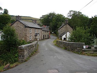
Staylittle, sometimes referred to colloquially as Y Stay or Y Stae, is a small village set in the shallow upland basin of the Afon Clywedog on the B4518 road, equidistant from Llanidloes and Llanbrynmair in the historic county of Montgomeryshire, Wales, although now administered as part of the unitary authority of Powys.
Timsbury is a village and civil parish in the Bath and North East Somerset unitary authority of the county of Somerset, 8 miles (13 km) south-west of Bath, close to the Cam Brook river. The parish, which includes the hamlets of Meadgate, Radford and Wall Mead, has a population of 2,624.

King's Walden is a civil parish in the English county of Hertfordshire. The name includes an apostrophe, but this is often omitted.

Chulmleigh is a small Saxon hilltop market town and civil parish located in North Devon in the heart of the English county of Devon. It is located 20 miles (32 km) north west of Exeter, just north of the Mid Devon boundary, linked by the A377 and B3096 roads.
Bont Dolgadfan is a small village off the B4518 road in Powys, Wales. It is part of the community of Llanbrynmair and forms a community ward for elections to the community council.

Goldington is an electoral ward within the town of Bedford, Bedfordshire, England. It encompasses much of the historic village and parish of Goldington that was merged with Bedford in 1934, although some parts of the old village are within the neighbouring Newnham ward. It also includes two modern estates that are part of Renhold Parish.

Dylife is a former mining settlement in Powys, Wales, located at the head of Afon Twymyn in the Cambrian Mountains, one mile west of the road between Llanidloes and Llanbrynmair (B4518). It is in the historic county of Montgomeryshire. The nearby lead mines intermittently sustained mining communities from Roman times until the early 20th century. During the late 19th century, as mining declined after the 1860s so did Dylife's population. The remaining buildings are two former chapels converted into homes and the Star Inn.
Cwmdauddwr is a village in Powys, Wales. It is contiguous with the town of Rhayader on the opposite side of the River Wye. The village is located on the B4518 road linking Rhayader with the Elan Valley Reservoirs.
Pennant is a small village in Powys, mid Wales located on the B4518 road between Llanbrynmair and Llanidloes.

The B4518 road is a road in Powys, central Wales, with a total length of 30.5 miles (49.1 km). It begins at 52°18′5″N3°30′41″W in Rhayader near the junction of the A470 road and the A44 road and leads eventually to the A470 again at Llanbrynmair at 52°36′42″N3°37′38″W. En route going north from Rhayader it passes through the following settlements: St Harmon, Pant-y-Dwr, Tylwch, Llanidloes, Staylittle, Pont Crugnant, Pennant, Bont Dolgadfan, Llan and Plas Esgair. It passes through the Clywedog Valley and Clywedog Reservoir, built in 1964.


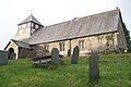 St Mary's parish church
