Caer is a placename element in Welsh meaning "stronghold", "fortress", or "citadel", roughly equivalent to an Old English suffix (-ceaster) now variously written as -caster, -cester, and -chester.

Powys is a county and preserved county in Wales. It borders Gwynedd, Denbighshire, and Wrexham to the north; the English ceremonial counties of Shropshire and Herefordshire to the east; Monmouthshire, Blaenau Gwent, Merthyr Tydfil, Caerphilly, Rhondda Cynon Taf, and Neath Port Talbot to the south; and Carmarthenshire and Ceredigion to the west. The largest settlement is Newtown, and the administrative centre is Llandrindod Wells.

Montgomeryshire is one of thirteen historic counties and a former administrative county of Wales. It is named after its county town, Montgomery, which in turn is named after one of William the Conqueror's main counsellors, Roger de Montgomerie, who was the 1st Earl of Shrewsbury.

The Cornovīī were a Celtic people of the Iron Age and Roman Britain, who lived principally in the modern English counties of Cheshire, Shropshire, north Staffordshire, north Herefordshire and eastern parts of the Welsh counties of Flintshire, Powys and Wrexham. Their capital in pre-Roman times was probably a hillfort on the Wrekin. Ptolemy's 2nd-century Geography names two of their towns: Deva Victrix (Chester) and Viroconium Cornoviorum (Wroxeter), which became their capital under Roman rule.

The Ordovīcēs were one of the Celtic tribes living in Great Britain before the Roman invasion. Their tribal lands were located in present-day North Wales and England, between the Silures to the south and the Deceangli to the north-east. Unlike the latter tribes that appear to have acquiesced to Roman rule with little resistance, the Ordovices fiercely resisted the Romans. They were eventually subjugated by the Roman governor Gnaeus Julius Agricola in the campaign of 77–78CE when the Romans overran their final strongholds on Anglesey.

Caersws is a village and community on the River Severn, in the Welsh county of Powys (Montgomeryshire) 5 miles (8 km) west of Newtown, and halfway between Aberystwyth and Shrewsbury. It has a station on the Cambrian Line from Aberystwyth to Shrewsbury. At the 2011 Census, the community had a population of 1,586 – a figure which includes the settlements of Clatter, Llanwnnog and Pontdolgoch. The village itself had a population of slightly over 800.

Wroxeter is a village and former civil parish, now in the parish of Wroxeter and Uppington, in the Shropshire district, in the ceremonial county of Shropshire, England. It is beside the River Severn, 5 miles (8.0 km) south-east of Shrewsbury. In 1961 the parish had a population of 657.
Mediolanum is the ancient name of Milan, Italy.

Meifod, formerly also written Meivod, is a small village, community and electoral ward 7 miles north-west of Welshpool in Montgomeryshire, Powys, Wales, on the A495 road and located in the valley of the River Vyrnwy. The River Banwy has a confluence with the Vyrnwy approximately two miles to the west of the village. The village itself had a population of 317. The community includes the village of Bwlch-y-cibau and the hamlet of Allt-y-Main.
The Central Wales Football League(formerly the Mid Wales Football League) is a football league in Wales at tier four of the Welsh Football pyramid, run by the Central Wales Football Association. The league consists of two regionally based divisions - a Northern Division and a Southern Division. The league offers a promotion route to the Football Association of Wales administered tier three Ardal Leagues. Relegation is possible to the relevant tier five level leagues in Aberystwyth, Ceredigion and Montgomeryshire.
Llansantffraid-ym-Mechain is a large village in Powys, Mid Wales, close to the border with Shropshire in England, about 7 miles (11 km) south-west of Oswestry and 8 miles (13 km) north of Welshpool. It is on the A495 road and is at the confluence of the River Vyrnwy and the River Cain. The population as of the 2011 UK census was 1,415. The community includes the village of Deuddwr and several hamlets.

Llanfyllin is a market town and community in Powys, Wales. The town population in 2021 was 1,586 and the town's name means church or parish (llan) of St Myllin. The community includes the settlements of Bodfach, Ty Crwyn, Abernaint and several farms.

Rhwng Gwy a Hafren was a region of medieval Wales, located in the Welsh Marches between Powys to the north and Brycheiniog to the south. It was bounded by the rivers Wye and Severn. It covered about the same territory as Radnorshire, now part of the county of Powys. The region first came into its own in the 9th or 10th centuries, when it was ruled by leaders who operated independently of the surrounding kingdoms. After the Norman invasion, it comprised the central part of the Welsh Marches and was the site of frequent struggles between Welsh and Norman forces.
The Montgomeryshire Football League is a football league in Mid Wales, sitting at the fifth level of the Welsh football league system.

Arwystli was a cantref in mid Wales in the Middle Ages, located in the headland of the River Severn. It was chiefly associated with the Kingdom of Powys, but was heavily disputed between Powys, Gwynedd, and the Norman Marcher Lords for hundreds of years, and was the scene of many skirmishes between those groups. Like many other cantrefs and subdivisions, it was divided up by the Laws in Wales Acts in the 16th century.
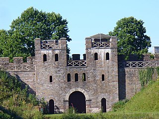
Forden Gaer, Y Gaer, Caer Flos and Lavrobrinta are respective English, Welsh and possible Latin names for the Roman fort in the township of Thornbury, in the parish of Forden, in the old county of Montgomeryshire, which now forms part of Powys, Wales. The fort lies on the E bank of the Severn a short distance N of Montgomery, and covers an important crossing of the river close to the historic ford at Rhydywhyman. It is likely that this is the same fort as Lavrobrinta, which is mentioned in the Ravenna Cosmography. The fort lies on the Roman Road between Wroxeter and Caersws. The defences were originally of earth, subsequently revetted with a timber-laced rampart of clay. Some internal buildings may have been of stone. The fort was established ca. A.D. 75-80 and was not finally abandoned before the reign of Valentinian I. The finds are in the Powysland Museum, Welshpool.
Cefn Carnedd is an Iron Age hillfort, about 1.5 miles (2 km) south-west of Caersws, in Powys, Wales. It is a scheduled monument.


