Llanerfyl | |
---|---|
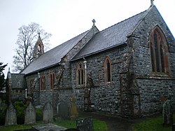
![]() St Erfyl's church, Llanerfyl | |
Location within Powys | |
Population | 406 (2011) |
OS grid reference | SJ041130 |
Community |
|
Principal area | |
Preserved county | |
Country | Wales |
Sovereign state | United Kingdom |
Post town | WELSHPOOL |
Postcode district | SY21 |
Dialling code | 01938 |
Police | Dyfed-Powys |
Fire | Mid and West Wales |
Ambulance | Welsh |
UK Parliament | |
Senedd Cymru – Welsh Parliament | |
Llanerfyl is a village and community in Montgomeryshire, Powys, Wales. Located near the River Banwy, the community includes the village of Llanerfyl, several farms and wide tracts of marchland. The southern part of the community includes Cwm Nant yr Eira, which suffered severe depopulation in the 20th century. [2] The 2001 census gives the population of the community as 402, increasing slightly to 406 at the 2011 Census. [3]
The village contains St Erfyl's church, named after Erfyl, rebuilt in 1870. It contains the remnants of a 15th-century shrine. The circular churchyard has in it a gravestone from either the 5th or 6th century commemorating the death of a young girl, identified locally with Erfyl:
HIC [IN] / TUM(V)LO IAC/IT R[O]STE/ECE FILIA PA/TERNINI / AN(N)IS XIII IN / PA(CE) ('In the grave here lies *Rhostege daughter of Padarn, 13 years, in peace').
Gwynedd is a county in the north-west of Wales. It borders Anglesey across the Menai Strait to the north, Conwy, Denbighshire, and Powys to the east, Ceredigion over the Dyfi estuary to the south, and the Irish Sea to the west. The city of Bangor is the largest settlement, and the administrative centre is Caernarfon. The preserved county of Gwynedd, which is used for ceremonial purposes, includes the Isle of Anglesey.
Llanrhaeadr-ym-Mochnant is a village and community in Powys, Wales; about 9 miles west of Oswestry and 12 miles south of Llangollen, on the B4580. It lies near the foothills of the Berwyn mountains on the river Rhaeadr. At the top end of the valley is the Pistyll Rhaeadr waterfall, one of the Seven Wonders of Wales in the old rhyme. One mile north of the town is the hill Moel Hen-fache. The community includes the hamlet of Llanarmon Mynydd Mawr.
Aberdyfi, also known as Aberdovey, is a village and community in Gwynedd, Wales, located on the northern side of the estuary of the River Dyfi.
Llanfair Caereinion is a market town and community in Montgomeryshire, Powys, Wales upon the River Banwy, around 8 miles west of Welshpool. In 2011 the ward had a population of 1,810; the town itself had a population of 1,055 according to Nomis.
Pentraeth is a village and community on the island of Anglesey, North Wales, at grid reference SH523786. The Royal Mail postcode begins LL75. The community population taken at the 2011 census was 1,178. The village itself having a population of 557.
Y Felinheli, formerly known in English as Port Dinorwic, is a village and community beside the Menai Strait between Bangor and Caernarfon in Gwynedd, northwest Wales.
Penmynydd, meaning "top of the mountain" in Welsh, is a village and community on Anglesey, Wales. It is known for being the birthplace of the Tudors of Penmynydd, which became the House of Tudor. The population according to the United Kingdom Census 2011 was 465. The community includes the village of Star and the hamlet of Castellior.
Talybont-on-Usk is a village and community in Powys, Wales, in the historic county of Brecknockshire. It lies on both the Caerfanell river and the Monmouthshire and Brecon Canal, about 1 mile (1.6 km) from the River Usk. In 2001, it had a population of 743, reducing to 719 at the 2011 census. The community includes the settlements of Llansantffraed, Scethrog, Aber Village, and Pencelli.
Clynnog Fawr, often simply called Clynnog, is a village and community on the north coast of Llŷn Peninsula in Gwynedd, north-west Wales. It is in the historic county of Caernarfonshire. The community includes Pant Glas.
Treuddyn is a village, community and electoral ward in Flintshire, Wales, located just off the A5104 road, around 4 miles south-east of Mold and 3 miles north-west of Caergwrle. The community includes the nearby village of Coed Talon, to the east, and Rhydtalog, to the south-west on the Denbighshire border.
Camrose is a village, parish and community in the historic cantref of Roose in Pembrokeshire, Wales. The community includes the villages of Keeston and Wolfsdale. Since 1987 the parish has been expanded to include the whole historic parish of Lambston and parts of Haverfordwest St Martins.
Llancarfan is a rural village and community in the Vale of Glamorgan, Wales. The village, located west of Barry and near Cowbridge, has a well-known parish church, the site of Saint Cadoc's 6th-century clas, famed for its learning. Cainnech of Aghaboe, Caradoc of Llancarfan and many other Welsh holy men studied there. Antiquarian Iolo Morganwg was born in the hamlet of Pen-onn near Llancarfan. At the 2001 census, the community had a population of 736. In the 2011 census, the population was 747. Most of the village lies within a conservation area designated by the local authority in 1971. Buildings listed as being of special historic interest include The Fox and Hounds public house, the former Bethlehem Chapel, the former Wesleyan Chapel, Chapel Cottage, Great House, Corner House and Llancarfan Primary School. The community includes village of Moulton.
Llanbadarn Fawr is a village and community in Ceredigion, Wales. It is on the outskirts of Aberystwyth next to Penparcau and Southgate. It forms the eastern part of the continually built-up area of Aberystwyth. It holds two electoral wards, Padarn and Sulien which elect a Ceredigion County Councillor each and several Llanbadarn Fawr Community Councillors. At the 2001 census its population as a community was recorded at 2,899, increasing to 3,380 at the 2011 census.
Llanwddyn is a village and community in Montgomeryshire, Powys, Wales. The community is centred on the Lake Vyrnwy reservoir. The original Llanwddyn village, about 2 miles (3.2 km) northwest, was submerged when the reservoir was created in the 1880s.
Cynwyl Elfed is a village and community in the county of Carmarthenshire, Wales. The community includes the villages of Cynwyl Elfed, Blaenycoed and Cwmduad. It is situated about 5 miles (8.0 km) north of Carmarthen and had a population of 953 in 2001, increasing to 1,044 at the 2011 Census.
Llanllwni is a village and community in Carmarthenshire, Wales, on the A485 road south-west of Llanybydder. To the south lies the mountain, Mynydd Llanllwni. The population of 638 recorded in the 2011 Census was estimated to be 692 in 2019.
Llansannan is a rural village and community in Conwy County Borough, Wales. It lies on the bank of the River Aled and is about 8 miles to the south of Abergele and 9 miles (14 km) to the west of Denbigh. The population was 1,291 in 2001, with 67% able to speak Welsh. The figures for the 2011 census were: population 1,335 with 63% able to speak Welsh. The community includes the hamlets of Bylchau, Rhydgaled and Y Groes, and the lake Llyn Aled and reservoir Aled Isaf on Mynydd Hiraethog. Llansannan is in the traditional county of Denbighshire.
Llangelynnin is a small village and community near Tywyn, Gwynedd, Wales. Although the village is usually known as Llangelynnin in English, the community name previously used was Llangelynin, though it is now also spelt "Llangelynnin".
Ogmore Valley is a community in the Bridgend County Borough, Mid Glamorgan, Wales. Made up of the villages of Nantymoel, Ogmore Vale, Price Town and Wyndham, its population at the time of the 2001 census was 7,800, increasing to 7,954 at the 2011 Census. The ribbon housing of the valley follows the Ogwr Fawr tributary which rises at Craig Ogwr and joins the Ogwr Fach at Blackmill. Villages include Nantymoel, Price Town, Wyndham, Ogmore Vale, Lewistown, Pant-yr-awel and Blackmill.
Banwy is a community in northwest Montgomeryshire, Powys, Wales, named after the River Banwy and also called Banw in Welsh.