
The Hume Highway, including the sections now known as the Hume Freeway and the Hume Motorway, is one of Australia's major inter-city national highways, running for 840 kilometres (520 mi) between Melbourne in the southwest and Sydney in the northeast. Upgrading of the route from Sydney's outskirts to Melbourne's outskirts to dual carriageway was completed on 7 August 2013.

Pymble is a suburb on the Upper North Shore of Sydney in the state of New South Wales, Australia. Pymble is 15 kilometres (9 mi) north of the Sydney central business district in the local government area of Ku-ring-gai Council.
Betws-y-Coed is a village and community in the Conwy valley in Conwy County Borough, Wales, located in the historic county of Caernarfonshire, right on the boundary with Denbighshire, in the Gwydir Forest. It is now a very popular visitor destination in the Snowdonia National Park. The population of the community as of the 2021 census was 476, a decline on the previous census.
Llangammarch Wells or simply Llangammarch is a village in the community of Llangamarch in Powys, Wales, lying on the Afon Irfon, and in the historic county of Brecknockshire (Breconshire).

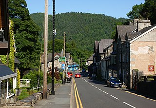
Llanwrtyd Wells is a market town and community in Powys, Wales, in the historic county of Brecknockshire (Breconshire) on the Afon Irfon. The town is on the A483 between Llandovery and Builth Wells and is located near the pass between the Tywi and Irfon valleys.
The Afan Forest Park is a 48-square-mile (120 km2) forest park in Britain. It is set in the Afan Valley in Neath Port Talbot, in south Wales. It is well known for its mountain biking and hiking or hillwalking trails. It is situated seven miles (11 km) from Junction 40 of the M4.

Cuddington is a civil parish and rural village in the unitary authority of Cheshire West and Chester and the ceremonial county of Cheshire, England, about 4 miles west of Northwich and 13 miles east of Chester.

Abergwesyn is a village in the Welsh county of Powys, in mid-Wales, at the start of the Abergwesyn valley and at the confluence of the Afon Irfon and the Afon Gwesyn. It is 52 miles (84 km) from Cardiff and 158 miles (254 km) from London.

The Diocese of Swansea and Brecon is a Diocese of the Church in Wales, established in 1923 with Brecon Priory as the cathedral. The area of the diocese had formerly been the Archdeaconry of Brecon within the Diocese of St Davids. The diocese has a border with each of the other five Welsh dioceses, as well as with the English Diocese of Hereford.

Gundaroo is a small village in the Southern Tablelands of New South Wales, Australia and in Yass Valley Council. It is situated to the east of the Yass River, about 16 kilometres (10 mi) north of Sutton, about 15 kilometres (9 mi) west of the Lake George range. At the 2016 census, Gundaroo "state suburb" had a population of 1,146. At the 2006 census, its "urban centre/locality" had a population of 331.
National Cycle Network, Route 43 is part of the National Cycle Network and the Celtic Trail, which connects Swansea with Builth Wells. Most of the route is still awaiting development. As of June 2006, there is a 13-mile section out of Swansea that is open and signed.

Mount Wilson is a village in the Blue Mountains region of New South Wales, Australia. The village is about 14 kilometres (8.7 mi) east of the township of Bell, and about 100 kilometres (62 mi) west of the Sydney CBD. At the 2021 census, the village of Mount Wilson had a population of 81 people. Mount Wilson is known for its multiple large gardens, walks and access to nature, and popularity as a base for practitioners of canyoning.
Devauden is a village and community in Monmouthshire, southeast Wales. It is located between Chepstow and Monmouth near the top of the Trellech ridge on the B4293 road. The community covers an area of 3,790 hectares (14.6 sq mi), and includes the villages of Itton and Wolvesnewton, Llanfihangel-tor-y-mynydd and Newchurch.

Mynydd Epynt is an upland region of Mid Wales, within the county of Powys. It is bounded on the south by the upper stretch of the Usk Valley, on the north by the Irfon Valley, and on the east by the Wye Valley. Its western boundary is less distinct but lies east of the A483 Llandovery to Llanwrtyd Wells road.

The Epynt Way is a long-distance path created by the Ministry of Defence in 2004 around the perimeter of its 'Sennybridge Training Area (SENTA)' and artillery range on Mynydd Epynt in Powys, Wales. There is, understandably, virtually no public access across the land used by the MoD, pre-existing public rights of way and public roads having been closed, with only one or two exceptions. The establishment of the Epynt Way, section by section in recent years has gone some way to compensating for that reduction in public access across the area.

Wollombi is a small village in the Hunter Region of New South Wales, Australia. It is within the Cessnock City Council LGA, situated 29 kilometres (18 mi) southwest of Cessnock and 128 km (80 mi) north of Sydney. To the south is the village of Laguna, to the east, the village of Millfield and to the north, the village of Broke.

The Dublin Mountains Way is a waymarked long-distance trail in the Dublin Mountains, Counties South Dublin and Dún Laoghaire–Rathdown, Ireland. The route is approximately 42 kilometres long and runs from Shankill in the east to Tallaght in the west. It has been developed by the Dublin Mountains Partnership, an umbrella group of relevant state agencies and recreational users working to improve recreational facilities in the Dublin Mountains.

Duhonw is a rural community in Powys, Wales, to the south of Builth Wells, in the historic county of Breconshire. Covering an area of 4,376 hectares (16.90 sq mi) and including scattered farms and dwellings, it is bounded to its north by the Afon Irfon, to its south by Mynydd Epynt and Banc y Celyn (472m) and to its east the rivers Duhonw and Wye. Llangammarch Wells' is to its west.

Dyfnant Forest is a remote forest in northeastern-central Powys, Wales.
Llandeilo'r-Fan is a small village located in Powys, Wales. It is located between Llandovery and Brecon. It is very rural and is located in a hilly area of mid wales. The village has a church, community hall and a few houses. The nearest shop and pub are in Sennybridge.


