
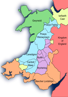
Radnorshire is a sparsely populated area, one of thirteen historic and former administrative counties of Wales. It is represented by the Radnorshire area of Powys, which according to the 2011 census, had a population of 25,821. The historic county was bounded to the north by Montgomeryshire and Shropshire, to the east by Herefordshire, to the south by Brecknockshire and to the west by Cardiganshire.

Llandrindod Wells is a town and community in Powys, within the historic boundaries of Radnorshire, Wales. It serves as the seat of Powys County Council and thus the administrative centre of Powys.
The Treaty of Montgomery was an Anglo-Cambrian treaty signed on 29 September 1267 in Montgomeryshire by which Llywelyn ap Gruffudd was acknowledged as Prince of Wales by King Henry III of England. It was the only time an English ruler recognised the right of a ruler of Gwynedd over Wales. Llywelyn's grandfather Llywelyn the Great had previously laid claim to be the effective prince of Wales by using the title "Prince of Aberffraw, Lord of Snowdon" in the 1230s, after subduing all the other Welsh dynasties. Likewise Llywelyn's uncle, Dafydd ap Llywelyn, claimed the title of Prince of Wales during his reign from 1240 to 1246. However, Llywelyn's supremacy in the late 1260s forced recognition of his authority in Wales by an English Crown weakened by internal division.

Radnor Forest in the county of Radnorshire, Wales is a rock dome composed of Silurian shales, mudstones and limestone in Mid Wales. It is a forest in the medieval sense of the word. It lies within the Welsh Marches region since Offa's Dyke lies nearby to the east.
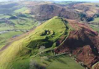
Cefnllys Castle was a medieval spur castle in Radnorshire, Wales. Two successive masonry castles were built on a ridge above the River Ithon known as Castle Bank in the thirteenth century, replacing a wooden motte-and-bailey castle constructed by the Normans nearby. Controlling several communication routes into the highlands of Mid Wales, the castles were strategically important within the Welsh Marches during the High Middle Ages. As the seat of the fiercely contested lordship and cantref of Maelienydd, Cefnllys became a source of friction between Llywelyn ap Gruffudd and Roger Mortimer in the prelude to Edward I's conquest of Wales. Cefnllys was also the site of a borough and medieval town.

Maelienydd, sometimes spelt Maeliennydd, was a cantref and lordship in east central Wales covering the area from the River Teme to Radnor Forest and the area around Llandrindod Wells. The area, which is mainly upland, is now in Powys. During the Middle Ages it was part of the region known as Rhwng Gwy a Hafren and its administrative centre was at Cefnllys Castle.
Ranulph I de Mortimer was a Marcher Lord from the Montgomery lands in the Welsh Marches. In England, he was Lord of Wigmore in Herefordshire. In Normandy, he was the Seigneur of St. Victor-en-Caux. Ranulph was the founder of the English House of Mortimer of Wigmore. He acquired Wigmore Castle after William Fitz Osbern's son Roger de Breteuil joined the Revolt of the Earls of 1075. His lands and holdings in Herefordshire and Shropshire were granted to him by William the Conqueror before 1086.

Clyro is a village and community in Radnorshire, Powys, Wales, with 781 inhabitants as of the 2011 UK Census. The nearest town is Hay-on-Wye, some 1.5 miles (2.4 km) to the south-east.
Knucklas is a village in Powys, Wales, previously Radnorshire. It lies in the upper valley of the River Teme, just off the B4355 road and is served by Knucklas railway station on the Heart of Wales Line. It is approximately 2 miles (3.2 km) from the market town of Knighton.

The Hundred of Roose was a hundred in Pembrokeshire, Wales. It has its origins in the pre-Norman cantref of Rhos and was formalised as a hundred by the Laws in Wales Acts 1535–1542. Its area was about 102 square miles (260 km2). The area became an English "plantation" in the 12th century, part of the English-speaking Little England beyond Wales.

Gwrtheyrnion or Gwerthrynion was a commote in medieval Wales, located in Mid Wales on the north side of the River Wye; its historical centre was Rhayader. It is said to have taken its name from the legendary king Vortigern. For most of the medieval era, it was associated with the cantref of Buellt and then Elfael, small regional kingdoms whose rulers operated independently of other powers. In the Norman era, like the rest of the region between Wye and Severn it came to be dominated by Marcher Lordships.
Rhwng Gwy a Hafren was a region of medieval Wales, located in the Welsh Marches between Powys to the north and Brycheiniog to the south. It was bounded by the rivers Wye and Severn. It covered about the same territory as Radnorshire, now part of the county of Powys. The region first came into its own in the 9th or 10th centuries, when it was ruled by leaders who operated independently of the surrounding kingdoms. After the Norman invasion, it comprised the central part of the Welsh Marches and was the site of frequent struggles between Welsh and Norman forces.
Glasbury, also known as Glasbury-on-Wye, is a village and community in Powys, Wales. The village lies at an important crossing point on the River Wye, connecting the historic counties of Brecknockshire and Radnorshire, and is located just outside the Brecon Beacons National Park, north of the Black Mountains. The village is split between the communities of Glasbury and Gwernyfed. The nearest town is Hay-on-Wye, some 4 miles (6 km) to the north east. The nearest city is Hereford in England, some 25 miles (40 km) to the east. Glasbury is a popular location for river fishing, canoeing and kayaking. The population of Glasbury community in Radnorshire was 994, in 1841 it was 838.

Elfael was one of a number of Welsh cantrefi occupying the region between the River Wye and river Severn, known as Rhwng Gwy a Hafren, in the early Middle Ages. It was divided into two commotes, Is Mynydd and Uwch Mynydd, separated by the chain of hills above Aberedw. In the late medieval period, it was a marcher lordship. However, after the Laws in Wales Act of 1535, it was one of the territorial units which went to make up the county of Radnorshire in 1536.

Buellt or Builth was a cantref in medieval Wales, located west of the River Wye. Unlike most cantrefs, it was not part of any of the major Welsh kingdoms for most of its history, but was instead ruled by an autonomous local dynasty. During the Norman era it was associated with Rhwng Gwy a Hafren, a region independent of the Welsh monarchies and controlled by Norman Marcher Lords. In the 16th century, it was reorganized as a hundred and joined with the former kingdom of Brycheiniog to form the county of Brecknockshire.

Colwyn Castle was a medieval castle near Llansantffraed in Wales. In the Manor of Glascwm, in the county of Radnorshire.It was built on the site of a Roman fort. The castle was captured in 1196 by Rhys ap Gruffydd, who was campaigning against the Normans. It was rebuilt in 1242 by Ralph de Mortimer to protect the lordship of Maelienydd, which he had recently acquired.
The conquest of Wales by Edward I, sometimes referred to as the Edwardian Conquest of Wales, to distinguish it from the earlier Norman conquest of Wales, took place between 1277 and 1283. It resulted in the defeat and annexation of the Principality of Wales, and the other last remaining independent Welsh principalities, by Edward I, King of England.

Glascwm is a community in the upper Edw valley in Radnorshire, Powys, Wales. The main settlement is concentrated in the two centrally located small villages of Frank's Bridge, located on the eastern slope of the valley, and Hundred House, located on the river terrace on the western side of the Edw. The remainder of the population lives in scattered farms and dwellings and in the three rural settlements of Cregrina, Glascwm, Bettws Diserth and Llansantffraed-in-Elwel. The surrounding area has extensive uninhabited uplands of moorland at Carneddau, Gilwern Hill, Gwaunceste Hill, Little Hill and Glascwm Hill. The A481 passes through the area. In 2005 Powys county council recorded a population of 479, increasing to 551 at the 2011 Census.
Cedewain was a medieval cantref in the Kingdom of Powys. It possibly consisted of the commotes (cymydau) of Cynan, Hafren and Uwch Hanes. Other sources give the commotes as Cedewain, Eginlle and Ceri.
Dinieithon was a commote within the cantref of Maelienydd, in the medieval region of Rhwng Gwy a Hafren in Wales. It was situated near the modern town of Llandrindod Wells.

