
Montgomeryshire is one of thirteen historic counties and a former administrative county of Wales. It is named after its county town, Montgomery, which in turn is named after one of William the Conqueror's main counsellors, Roger de Montgomerie, who was the 1st Earl of Shrewsbury.

Radnorshire is one of the thirteen historic counties of Wales and a former administrative county. It covers a sparsely populated area in mid Wales. The historic county was bounded to the north by Montgomeryshire and Shropshire, to the east by Herefordshire, to the south by Brecknockshire and to the west by Cardiganshire.

The Kingdom of Powys was a Welsh successor state, petty kingdom and principality that emerged during the Middle Ages following the end of Roman rule in Britain. It very roughly covered the northern two-thirds of the modern county of Powys and part of today's English West Midlands. More precisely, and based on the Romano-British tribal lands of the Ordovices in the west and the Cornovii in the east, its boundaries originally extended from the Cambrian Mountains in the west to include the modern West Midlands region of England in the east. The fertile river valleys of the Severn and Tern are found here, and this region is referred to in later Welsh literature as "the Paradise of Powys".

The Treaty of Montgomery was an Anglo-Welsh treaty signed on 29 September 1267 in Montgomeryshire by which Llywelyn ap Gruffudd was acknowledged as Prince of Wales by King Henry III of England. It was the only time an English ruler recognised the right of a ruler of Gwynedd over Wales. Llywelyn's grandfather Llywelyn the Great had previously laid claim to be the effective prince of Wales by using the title "Prince of Aberffraw, Lord of Snowdon" in the 1230s, after subduing all the other Welsh dynasties. Likewise Llywelyn's uncle, Dafydd ap Llywelyn, claimed the title of Prince of Wales during his reign from 1240 to 1246. However, Llywelyn's supremacy in the late 1260s forced recognition of his authority in Wales by an English Crown weakened by internal division.
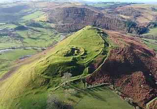
Cefnllys Castle was a medieval spur castle in Radnorshire, Wales. Two successive masonry castles were built on a ridge above the River Ithon known as Castle Bank in the thirteenth century, replacing a wooden motte-and-bailey castle constructed by the Normans nearby. Controlling several communication routes into the highlands of Mid Wales, the castles were strategically important within the Welsh Marches during the High Middle Ages. As the seat of the fiercely contested lordship and cantref of Maelienydd, Cefnllys became a source of friction between Llywelyn ap Gruffudd and Roger Mortimer in the prelude to Edward I's conquest of Wales (1277–1283). Cefnllys was also the site of a borough and medieval town.
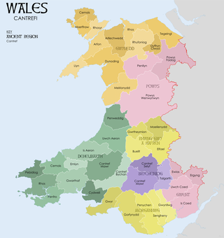
A cantref was a medieval Welsh land division, particularly important in the administration of Welsh law.
Ranulph I de Mortimer was a Marcher Lord from the Montgomery lands in the Welsh Marches. In England, he was Lord of Wigmore in Herefordshire. In Normandy, he was the Seigneur of St. Victor-en-Caux. Ranulph was the founder of the English House of Mortimer of Wigmore. He acquired Wigmore Castle after William Fitz Osbern's son Roger de Breteuil joined the Revolt of the Earls of 1075. His lands and holdings in Herefordshire and Shropshire were granted to him by William the Conqueror before 1086.

Chirkland was a marcher lordship in north-east Wales. It was created in 1282 from parts of Powys Fadog granted to Roger Mortimer de Chirk, third son of Roger Mortimer, 1st Baron Mortimer of Wigmore, who then built Chirk Castle from where the lordship was administered.

Gwrtheyrnion or Gwerthrynion was a commote in medieval Wales, located in Mid Wales on the north side of the River Wye; its historical centre was Rhayader. It is said to have taken its name from the legendary king Vortigern. For most of the medieval era, it was associated with the cantref of Buellt and then Elfael, small regional kingdoms whose rulers operated independently of other powers. In the Norman era, like the rest of the region between Wye and Severn it came to be dominated by Marcher Lordships.
Rhwng Gwy a Hafren was a region of medieval Wales, located in the Welsh Marches between Powys to the north and Brycheiniog to the south. It was bounded by the rivers Wye and Severn. It covered about the same territory as Radnorshire, now part of the county of Powys. The region first came into its own in the 9th or 10th centuries, when it was ruled by leaders who operated independently of the surrounding kingdoms. After the Norman invasion, it comprised the central part of the Welsh Marches and was the site of frequent struggles between Welsh and Norman forces.

Elfael was one of a number of Welsh cantrefi occupying the region between the River Wye and river Severn, known as Rhwng Gwy a Hafren, in the early Middle Ages. It was divided into two commotes, Is Mynydd and Uwch Mynydd, separated by the chain of hills above Aberedw. In the late medieval period, it was a marcher lordship. However, after the Laws in Wales Act of 1535, it was one of the territorial units which went to make up the county of Radnorshire in 1536.

Buellt or Builth was a cantref in medieval Wales, located west of the River Wye. Unlike most cantrefs, it was not part of any of the major Welsh kingdoms for most of its history, but was instead ruled by an autonomous local dynasty. During the Norman era it was associated with Rhwng Gwy a Hafren, a region independent of the Welsh monarchies and controlled by Norman Marcher Lords. In the 16th century, it was reorganized as a hundred and joined with the former kingdom of Brycheiniog to form the county of Brecknockshire.

Colwyn Castle was a medieval castle near Llansantffraed in Wales. In the Manor of Glascwm, in the county of Radnorshire.It was built on the site of a Roman fort. The castle was captured in 1196 by Rhys ap Gruffydd, who was campaigning against the Normans. It was rebuilt in 1242 by Ralph de Mortimer to protect the lordship of Maelienydd, which he had recently acquired.
Caerwedros was a medieval commote in the south of the Kingdom of Ceredigion. With Mebwynion, Gwynionydd and Is Coed, Caerwedros was one of three cantref Is Aeron commotes.
Cedewain was a medieval cantref in the Kingdom of Powys. It possibly consisted of the commotes (cymydau) of Cynan, Hafren and Uwch Hanes. Other sources give the commotes as Cedewain, Eginlle and Ceri.

Cefnllys is an abandoned ghost village, formerly a medieval castle town and borough, near Llandrindod Wells in Radnorshire, Wales. The settlement was founded during the 13th century by the Mortimer family in order to strengthen their hold on land in the vicinity of the Cefnllys Castle, with which the town was closely associated. The town was probably intended to become the primary settlement of the lordship and cantref of Maelienydd, but was unsuccessful and declined during the 14th century as a result of bubonic plague outbreaks, economic isolation and military insecurity. Despite this, Cefnllys retained its borough status until the 19th century.


