Gwrtheyrnion

Last updated
Map of the lands west of Offa's Dyke; Gwrtheyrnion can be seen in the centre Rhwng.Gwy.a.Hafren.jpg
Map of the lands west of Offa's Dyke; Gwrtheyrnion can be seen in the centre

Gwrtheyrnion or Gwerthrynion was a commote in medieval Wales, located in Mid Wales on the north side of the River Wye; its historical centre was Rhayader. It is said to have taken its name from the legendary king Vortigern (Welsh : Gwrtheyrn). For most of the medieval era, it was associated with the cantref of Buellt and then Elfael, small regional kingdoms whose rulers operated independently of other powers. In the Norman era, like the rest of the region between Wye and Severn it came to be dominated by Marcher Lordships.

Contents

Name and boundaries

According to the 9th-century Historia Brittonum , Gwrtheyrnion, here Latinised Guorthegirnaim, was named after Vortigern (Welsh : Gwrtheyrn), a legendary 5th-century King of Britain. [1] John Edward Lloyd considers this derivation accurate. [2] Generally, its boundaries were the cantrefi of Arwystli to the north, Maelienydd (in its restricted sense) to the east, Elfael to the southeast, and Buellt to the southwest. It also controlled the commote of Deuddwr (i.e. Cwmwd Deuddwr, also known as Elenydd) on the west of the Wye; together they formed a cantref. [3]

History

Early years

Territories in and adjacent to the region between Wye and Severn Map of the Cantrefs and Commotes of Rhwng Gwy a Hafren.svg
Territories in and adjacent to the region between Wye and Severn

The Historia Brittonum provides the earliest mention of Gwrtheyrnion. According to the text, Vortigern fled to Gwrtheyrnion after Saint Germanus of Auxerre had castigated him for his various sins. He eventually died, and his son Pascent received Gwrtheyrnion and Buellt from Ambrosius Aurelianus. [4]

One of the text's copyists, from whose copy most other surviving manuscripts are derived, took particular interest in this combined kingdom, tracing its medieval rulers back to Vortigern through Pascent. [5] The dynasty, so these manuscripts report, ended in a certain Ffernfael ap Tewdwr, who is also known from the genealogies from Jesus College MS 20. These Jesus College genealogies indicate that Ffernfael's cousin Brawstudd married Arthfael Hen ap Rhys, the ruler of Morgannwg, implying a floruit for Ffernfael around the early 9th century. [5]

Following Ffernfael's death, Buellt (and hence Gwrtheyrnion) came into the possession of neighbouring Arwystli, [6] for unclear reasons, after having temporarily been in the possession of Seisyllwg, for an unclear amount of time. At around this time, Arwystli's ruler was Iorwerth Hirflawdd; when Iorworth's son Idnerth died, his realm was re-divided, with Buellt (including Gwrtheyrnion) going to Cadwr Gwenwyn [7] (the rest of the realm - Arwystli - went to a different son).

Cadwr's grandson, and heir, married a granddaughter of Merfyn ap Rhodri, the king of Powys (this did not mean that Powys gained any authority over Buellt/Gwrtheyrnion [6] ); their grandson, and heir, was Elystan Glodrydd. Elystan Glodrydd conquered the adjacent land between the Wye and Severn - Ferlix (known also by various other spellings, such as Fferllys, Fferleg, and Fferregs) and incorporated it into his own realm. Elystan was succeeded by his son, Cadwgan, who was succeeded by his eldest son, Idnerth; a younger son gave rise to the Cadogan family, who were raised to the nobility many centuries later.

Normans

Due to their allegiances to the Saxon Kings (Elystan had been the god-son, and namesake, of King Athelstan), once the Normans invaded England, many Welsh princes had assisted anti-Norman revolts like that of Eadric the Wild. Hence, in 1080, when a revolt broke out in Northern England, the Normans pre-emptively occupied Wales, to prevent any further Welsh assistance to the Saxons. In turn, this led to a Welsh revolt in 1094, but by the end of the century it was successfully suppressed by a number of Norman magnates. The southern parts of Ferlix were conquered by Philip de Braose. [8] [9]

Eventually, like other Welsh princes, Idnerth came to a personal agreement with the local Norman magnate; Idnerth was restored to Gwrtheyrnion, and most of Ferlix, but Braose kept the rest of Buellt for himself. Following Idnerth's death, and that of his son, Madog, the retained parts of Ferlix were divided between Madog's sons: Cadwallon received most of the northern half, which became Maelienydd, while the remainder - Elfael - went to his brother, Einion Clud. Einion Clud was succeeded by his son, Einion o'r Porth.

Einion o'r Porth married Susanna, a daughter of Rhys ap Gruffydd, the ruling prince of Deheubarth. The only named ruler of Gwrtheyrnion in historic manuscripts (other than the legendary Pascent) is an Einion ap Rhys who visited the king in 1175, and was Rhys ap Gruffydd's son-in-law; unless this Einion ap Rhys is really a bodged reference to Einion o'r' Porth, then he, his father, and the consequently distinct line of rulers in Gwrtheyrnion, are otherwise entirely unknown. In 1177, Rhayader Castle was built in Gwrtheyrnion by Rhys ap Gruffydd.

Einion was murdered by his own brother, Gwalter. Einion's other brother, Iorwerth Clud, was able to depose Gwalter with the aid of Reginald de Braose (who had, by now, inherited Buellt), in alliance with Llywelyn Fawr (the most powerful Welsh prince). Unfortunately, Llywelyn's son (and successor), Dafydd, chose to repudiate the Treaty of Gwerneigron, which lead to Ralph Tosny seizing Elfael, although Tosny was later expelled from Elfael by Dafydd's nephew, Llywelyn ap Gruffudd. King Henry acknowledged Llywelyn ap Gruffudd's victory, by the Treaty of Montgomery. [10]

However, when Llywelyn ap Gruffudd married Eleanor de Montfort (the daughter of Henry's greatest enemy), Henry's son, Edward I (now King), declared Llywelyn a rebel, and attacked his lands. In 1277 Llywelyn was forced to agree the Treaty of Aberconwy, which made Llywelyn a vassal of Edward, and limited his authority to Gwynedd alone; Elfael was given to Ralph Tosny's grandson.

Later history

In the 15th century, the Tosny lands were inherited by Margaret Beauchamp of Bletso, and hence by her great-grandson, King Henry VIII. Following the latter's Laws in Wales Acts, Gwrtheyrnion and the rest of Ferlix became Radnorshire. In 1996, Radnorshire and the adjacent counties on either side - Montgomeryshire and Brecknockshire - became the main constituents of the modern county of Powys.

Notes

  1. Historia Brittonum, ch. 47.
  2. Lloyd, pp. 253–254.
  3. Rees, William (1951). An Historical Atlas of Wales from Early to Modern Times. Faber & Faber. Plate 28
  4. Historia Brittonum, ch. 47–49.
  5. 1 2 Lloyd, p. 224 and notes.
  6. 1 2 Owen, p. 203.
  7. Lloyd, p. 406 & note.
  8. Lloyd, pp. 402–405.
  9. British Archaeology, no 34, May 1998 (ISSN 1357-4442): Paul Remfry. Discovering the lost kingdom of Radnor
  10. Lloyd. pp. 739–740.

Related Research Articles

<span class="mw-page-title-main">Llywelyn ab Iorwerth</span> Prince of Gwynedd and de facto Prince of Wales

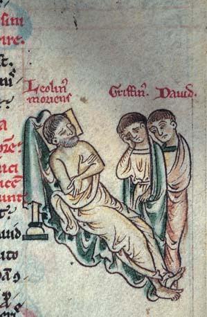
Llywelyn ab Iorwerth, also known as Llywelyn the Great was a medieval Welsh ruler. He succeeded his uncle, Dafydd ab Owain Gwynedd, as prince of Gwynedd in 1195 and became prince of Powys Wenwynwyn in 1216. By a combination of war and diplomacy he dominated Wales for 45 years.

<span class="mw-page-title-main">New Radnor</span> Human settlement in Wales

New Radnor is a village in Powys, Wales, to the south of Radnor Forest, and was the county town of Radnorshire.

<span class="mw-page-title-main">Rhys ap Tewdwr</span>

Rhys ap Tewdwr was a king of Deheubarth in Wales and member of the Dinefwr dynasty, a branch descended from Rhodri the Great. He was born in the area which is now Carmarthenshire and died at the battle of Brecon in April 1093.

<span class="mw-page-title-main">Maelienydd</span>

<span class="mw-page-title-main">Painscastle Castle</span>

Painscastle Castle is a castle in the village of Painscastle in Powys, Wales. It lies between Builth and Hay-on-Wye, approximately 3 miles from the Wales-England border today.

Cynllibiwg was evidently a place name in early medieval Wales.

This article is about the particular significance of the century 1201–1300 to Wales and its people.

This article is about the particular significance of the century 1101–1200 to Wales and its people.

<span class="mw-page-title-main">Rhwng Gwy a Hafren</span>

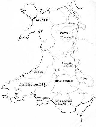
Rhwng Gwy a Hafren was a region of medieval Wales, located in the Welsh Marches between Powys to the north and Brycheiniog to the south. It was bounded by the rivers Wye and Severn. It covered about the same territory as Radnorshire, now part of the county of Powys. The region first came into its own in the 9th or 10th centuries, when it was ruled by leaders who operated independently of the surrounding kingdoms. After the Norman invasion, it comprised the central part of the Welsh Marches and was the site of frequent struggles between Welsh and Norman forces.

<span class="mw-page-title-main">Wales in the High Middle Ages</span> Aspect of Welsh history (1000–1300)

Wales in the High Middle Ages covers the 11th to 13th centuries in Welsh history. Beginning shortly before the Norman invasion of the 1060s and ending with the Conquest of Wales by Edward I between 1278 and 1283, it was a period of significant political, cultural and social change for the country.

<span class="mw-page-title-main">Wales in the Middle Ages</span> Period of history

Wales in the Middle Ages covers the history of the country that is now called Wales, from the departure of the Romans in the early fifth century to the annexation of Wales into the Kingdom of England in the early sixteenth century. This period of about 1,000 years saw the development of regional Welsh kingdoms, Celtic conflict with the Anglo-Saxons, reducing Celtic territories, and conflict between the Welsh and the Anglo-Normans from the 11th century.

Cadwallon ap Madog was the son of Madog ab Idnerth who had died in 1140, while Idnerth was a grandson of Elystan Glodrydd who had died in around 1010 and had founded a dynasty in the Middle Marches of Wales, in the area known as Rhwng Gwy a Hafren.

<span class="mw-page-title-main">Elfael</span>

Elfael was one of a number of Welsh cantrefi occupying the region between the River Wye and river Severn, known as Rhwng Gwy a Hafren, in the early Middle Ages. It was divided into two commotes, Is Mynydd and Uwch Mynydd, separated by the chain of hills above Aberedw. In the late medieval period, it was a marcher lordship. However, after the Laws in Wales Act of 1535, it was one of the territorial units which went to make up the county of Radnorshire in 1536.

<span class="mw-page-title-main">Elystan Glodrydd</span> Welsh royal

Elystan Glodrydd, also known as "Æthelstan the Famous" and "The Renowned," was, according to Welsh genealogical tracts, the founder of the fifth Royal Tribe of Wales. He was the Prince of Buellt, and later also of Fferreg ; in the century after his death, Fferreg split into Maelienydd and Elfael

<span class="mw-page-title-main">History of Gwynedd during the High Middle Ages</span>

The history of Gwynedd in the High Middle Ages is a period in the History of Wales spanning the 11th through the 13th centuries. Gwynedd, located in the north of Wales, eventually became the most dominant of Welsh polities during this period. Contact with continental courts allowed for Gwynedd to transition from a petty kingdom into an increasingly sophisticated principality of seasoned courtiers capable of high level deplomacy and representation; not only with the Angevine kings, but also the king of France and the Papal See. Distinctive achievements in Gwynedd include further development of Medieval Welsh literature, particularly poets known as the Beirdd y Tywysogion associated with the court of Gwynedd; the reformation of bardic schools; and the continued development of Cyfraith Hywel. All three of these further contributed to the development of a Welsh national identity in the face of Anglo-Norman encroachment of Wales.

<span class="mw-page-title-main">Buellt</span> Medieval cantref of Wales

Buellt or Builth was a cantref in medieval Wales, located west of the River Wye. Unlike most cantrefs, it was not part of any of the major Welsh kingdoms for most of its history, but was instead ruled by an autonomous local dynasty. During the Norman era it was associated with Rhwng Gwy a Hafren, a region independent of the Welsh monarchies and controlled by Norman Marcher Lords. In the 16th century, it was reorganized as a hundred and joined with the former kingdom of Brycheiniog to form the county of Brecknockshire.

Ffernfael ap Tewdwr was a king of Buellt and Gwrtheyrnion in medieval Wales. Little is known of him besides a pedigree included in the 9th-century Historia Brittonum, which makes him a descendant of the ruler Vortigern.

The Lordship of Brecknock was an Anglo-Norman marcher lordship located in southern central Wales.

<span class="mw-page-title-main">Rhayader Castle</span> Ruined castle in Powts, Wales

Rhayader Castle is the remains of a motte-and-bailey castle in the town of Rhayader, Powys, Wales. The available documentary sources are not clear enough to distinguish between this site and the castle mound across the river and one or the other was probably built by Rhys ap Gruffydd, Prince of Deheubarth, in 1177. At that time the river formed the border between Gwrtheyrnion and the independent state of Buellt; the town of Rhayader is on the Gwrtheyrnion side of the river.

<span class="mw-page-title-main">Painscastle</span>

Painscastle is a village and community in Powys, Wales which takes its name from the castle at its heart. It lies between Builth and Hay-on-Wye, approximately 3 miles from the Wales-England border today. The community also includes the villages and settlements of Rhosgoch, Bryngwyn, Llandeilo Graban and Llanbedr. The population as of the 2011 UK Census was 524. It is represented by the Painscastle and Rhosgoch Community Council, which comprises eight community councillors. It is included in the Glasbury electoral ward for Powys County Council elections.

References