
The history of what is now Wales begins with evidence of a Neanderthal presence from at least 230,000 years ago, while Homo sapiens arrived by about 31,000 BC. However, continuous habitation by modern humans dates from the period after the end of the last ice age around 9000 BC, and Wales has many remains from the Mesolithic, Neolithic, and Bronze Age. During the Iron Age the region, like all of Britain south of the Firth of Forth, the culture had become Celtic, with a common Brittonic language. The Romans, who began their conquest of Britain in AD 43, first campaigned in what is now northeast Wales in 48 against the Deceangli, and gained total control of the region with their defeat of the Ordovices in 79. The Romans departed from Britain in the 5th century, opening the door for the Anglo-Saxon settlement. Thereafter, the culture began to splinter into a number of kingdoms. The Welsh people formed with English encroachment that effectively separated them from the other surviving Brittonic-speaking peoples in the early middle ages.

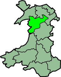
Powys is a county and preserved county in Wales. It borders Gwynedd, Denbighshire, and Wrexham to the north; the English ceremonial counties of Shropshire and Herefordshire to the east; Monmouthshire, Blaenau Gwent, Merthyr Tydfil, Caerphilly, Rhondda Cynon Taf, and Neath Port Talbot to the south; and Carmarthenshire and Ceredigion to the west. The largest settlement is Newtown, and the administrative centre is Llandrindod Wells.
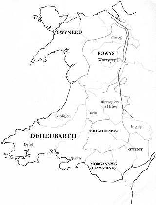
Deheubarth was a regional name for the realms of south Wales, particularly as opposed to Gwynedd. It is now used as a shorthand for the various realms united under the House of Dinefwr, but that Deheubarth itself was not considered a proper kingdom on the model of Gwynedd, Powys, or Dyfed is shown by its rendering in Latin as dextralis pars or as Britonnes dexterales and not as a named land. In the oldest British writers, Deheubarth was used for all of modern Wales to distinguish it from Hen Ogledd, the northern lands whence Cunedda originated.

Until 1974, Merionethshire or Merioneth was an administrative county in the north-west of Wales, later classed as one of the thirteen historic counties of Wales.

Meirionnydd is a coastal and mountainous region of Wales. It has been a kingdom, a cantref, a district and, as Merionethshire, a county. It is currently an committee area within the county Gwynedd.
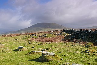
Ardudwy is an area of Gwynedd in north-west Wales, lying between Tremadog Bay and the Rhinogydd. Administratively, under the old Kingdom of Gwynedd, it was first a division of the sub kingdom (cantref) of Dunoding and later a commote in its own right. The fertile swathe of land stretching from Barmouth to Harlech was historically used as pasture. The name exists in the modern community and village of Dyffryn Ardudwy.

Dwyfor was one of the five local government districts of Gwynedd, Wales from 1974 to 1996, covering the Llŷn peninsula. Its council was based in Pwllheli.

Aberdyfi Castle is a castle located near Glandyfi, Ceredigion, in Wales. All that now remains is the motte, which is referred to as Domen Las.

Dwyfor Meirionnydd is a constituency of the House of Commons of the Parliament of the United Kingdom. The seat was created by the Welsh Boundary Commission for the 2010 general election, and replaced the old north Wales seat of Meirionnydd Nant Conwy. Dwyfor Meirionnydd is bordered to the north by Arfon and Aberconwy. The same boundaries were used for the Dwyfor Meirionnydd Welsh Assembly constituency in the 2007 Welsh Assembly election.

Rhufoniog was a small sub-kingdom of the Dark Ages Gwynedd, and later a cantref in medieval Wales.

Eifionydd is an area in north-west Wales covering the south-eastern part of the Llŷn Peninsula from Porthmadog to just east of Pwllheli. The Afon Erch forms its western border. It now lies in Gwynedd.
Llŷn was an ancient Welsh cantref in north-west Wales. It was part of the kingdom of Gwynedd for much of its history until it was included in the new county of Caernarfonshire, together with Arfon and Arllechwedd under the terms of the Statute of Rhuddlan in 1284.
Arllechwedd was an ancient Welsh cantref in north-west Wales. It was part of the kingdom of Gwynedd for much of its history until it was included in the new county of Caernarfonshire, together with Arfon and Llŷn under the terms of the Statute of Rhuddlan in 1284.
The Kingdom of Dyfed, one of several Welsh petty kingdoms that emerged in 5th-century sub-Roman Britain in southwest Wales, was based on the former territory of the Demetae. The medieval Irish narrative, The Expulsion of the Déisi, attributing the kingdom's founding to Eochaid, son of Artchorp, being forced across the Irish sea, in the 5th century; his descendants founding the line of the kings of Dyfed, down to "Tualodor mac Rígin". The Normans invaded Wales, and by 1138 incorporated Dyfed into a new shire called Pembrokeshire after the Norman castle built in the Cantref of Penfro and under the rule of the Marcher Earl of Pembroke.
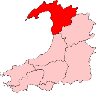
Dwyfor Meirionnydd is a constituency of the Senedd, first created for the former Assembly's 2007 election. It elects one Member of the Senedd by the first past the post method of election. Also, however, it is one of eight constituencies in the Mid and West Wales electoral region, which elects four additional members, in addition to nine constituency members, to produce a degree of proportional representation for the region as a whole.
The Battle of Mechain was fought in Powys, Wales, in 1070, for rule of the Welsh kingdoms of Gwynedd and Powys. The battlefield may be near Llanfechain in northern Powys. A written account is included in the Brut y Tywysogion, the medieval Welsh chronicle of the princes. It is also referred to in the work of medieval poets such as Lewys Glyn Cothi.
The Battle of Bryn Derwin was fought in Eifionydd, Gwynedd on June 1255, between Llywelyn ap Gruffudd and his brothers, Dafydd ap Gruffudd and Owain Goch ap Gruffydd.
Edeirnion or Edeyrnion is an area of the county of Denbighshire and an ancient commote of medieval Wales in the cantref of Penllyn. According to tradition, it was named after its eponymous founder Edern or Edeyrn. It was included as a Welsh territory of Shropshire in the Domesday Book.
The Battle of the Conwy took place in 881 between King Anarawd and his brothers of the northern Welsh Kingdom of Gwynedd and a Mercian army almost certainly led by Æthelred, Lord of the Mercians. The Welsh were victorious, and the battle ended the traditional hegemony of Mercia over north Wales and contributed to Æthelred's decision to accept the lordship of King Alfred the Great of Wessex. This united the Anglo-Saxons who were not living under Viking rule under Alfred, and was a step towards the creation of the Kingdom of England. Anarawd allied himself with the Vikings shortly after the battle, but he then abandoned this alliance to follow Æthelred in accepting Alfred's lordship.
