Buellt

Last updated
Map of the Welsh cantrefs, showing the location of Buellt, in the middle Cantrefi.Medieval.Wales.jpg
Map of the Welsh cantrefs, showing the location of Buellt, in the middle
Buellt, 1797 Builth.jpeg
Buellt, 1797

Buellt or Builth was a cantref in medieval Wales, located west of the River Wye. Unlike most cantrefs, it was not part of any of the major Welsh kingdoms for most of its history, but was instead ruled by an autonomous local dynasty. During the Norman era it was associated with Rhwng Gwy a Hafren, a region independent of the Welsh monarchies and controlled by Norman Marcher Lords. In the 16th century, it was reorganized as a hundred and joined with the former kingdom of Brycheiniog to form the county of Brecknockshire.

Contents

Description

The name Buellt, also rendered Buallt, comes from the Welsh words bu, meaning "ox", and gellt (later gwellt), meaning pasture. This was later anglicized to Builth, as in the modern town of Builth Wells. [1] [2]

Situated in the valley of Afon Irfon, Buellt's boundaries were roughly the Cambrian Mountains to the north, the River Wye to the east, the Mynydd Epynt range to the south, and Ceredigion to the west. It was closely associated with the territories of Gwrtheyrnion, Elfael, and Maelienydd, and as such was often considered part of the region known as Rhwng Gwy a Hafren (English: Between Wye and Severn) despite being west of the Wye. [3] The cantref was divided into four major commotes, whose boundaries are unclear: Treflys, Pebuellt, Dinan, and Is Irfon. Most of Buellt's major sites were located along the Irfon, including the courts of the commotes and the major church at Llanafan Fawr, dedicated to Saint Afan Buellt, the cantref's chief saint. [4]

Early history

The 9th- or 10th-century Llanynis pillar cross from Neuadd Siarman near Builth. Celtic Art in Pagan and Christian Times, p.188.png
The 9th- or 10th-century Llanynis pillar cross from Neuadd Siarman near Builth.

It is unknown when Buellt began to emerge as a distinct political unit. Its organization as a cantref seems to have developed along the earlier tribal boundaries of a gwlad ("people") or tud ("tribe"). [6] During the Early Middle Ages, Buellt and Gwrtheyrnion on the other side of the Wye formed a small regional kingdom. This kingdom's rulers traced their descent back to the legendary 5th-century warlord Vortigern (Welsh : Gwrtheyrn, from which Gwrtheyrnion was named.) [3]

The kingdom is known from the 9th-century Historia Brittonum , whose author, possibly a native of southeastern Wales, focused particular attention on it. [7] [8] [9] The Historia recounts that after Vortigern had invited the Anglo-Saxons to Britain and then been forced west, his son Pascent ruled Buellt and Gwrtheyrnion as a grant from Ambrosius Aurelianus. [10] Whatever the reality of this story, another section attributes descent from Pascent and Vortigern to Ffernfael ap Tewdwr, a 9th-century ruler of Buellt and Gwrtheyrnion known from other sources. [11]

The Historia further includes Buellt in its mirabilia section, or list of marvels. According to the text, Buellt is the location of the "Carn Cabal", a (since lost) petrosomatoglyph: the imprint of a dog's paw. This marvel is attributed to King Arthur's dog Cavall, who supposedly left the print while chasing the boar Troyt. Afterward, Arthur placed this stone on top of a cairn, and anyone who tried to move it would find it back in its place the next day. [12] The placename survives as Carn Gafallt near Rhayader, though it is unlikely the modern hill is the same one mentioned in the Historia. [13] [14] The prose tale Culhwch and Olwen contains a more elaborate version of Arthur's hunting of the divine boar, here known as Twrch Trwyth , however, in Culhwch the boar's detailed itinerary does not take him through Buellt. [13]

By the 11th century, Buellt and the rest of the Rhwng Gwy a Hafren passed under the control of a different dynasty tracing its descent to Elystan Glodrydd. [15]

Norman era

The site of the former Braose motte and bailey and the subsequent stone Builth Castle on the east end of modern Builth Wells Site of Builth Wells Castle - geograph.org.uk - 232924.jpg
The site of the former Braose motte and bailey and the subsequent stone Builth Castle on the east end of modern Builth Wells

During the High Middle Ages, several rulers from the surrounding kingdoms took control of Buellt, but it generally reverted to independence upon their death. During the Norman invasion of Wales, the Marcher Lord Philip de Braose conquered Buellt shortly after he took Rhwng Gwy a Hafren in 1095. [16] Philip fortified the hill east of present-day Builth Wells with a wooden motte and bailey castle and held the area until his death in 1134, when it passed to his son William. [17] Through this period, however, the representatives of the old Welsh dynasty descended from Elystan contested the Marcher Lords' rule. [15] The area changed hands between multiple Norman and Welsh figures, including Roger Mortimer, Rhys ap Gruffudd and Llywelyn the Great. [18] Buellt passed to Llywelyn's grandson Llywelyn ap Gruffudd, whose rights to it (though not other parts of Rhwng Gwy a Hafren) were confirmed by King Henry III in the 1267 Treaty of Montgomery. [19] In November 1282, Edward I overran Buellt as part of his final conquest of Wales. [20]

St Mary's in Builth Wells, retaining its 14th-century tower St Mary's church Builth - geograph.org.uk - 1039201.jpg
St Mary's in Builth Wells, retaining its 14th-century tower

Edward ordered the construction of the stone Builth Castle on the site of Braose's burnt fort, although construction was halted for lack of funds. The castle saw action during Madog ap Llywelyn and Owain Glyndŵr's rebellions, but was subsequently abandoned. [21] [22] In the 17th century it was damaged by a fire and its stones were plundered; it has since almost entirely disappeared. [23]

In the 16th century, as part of Henry VIII's Laws in Wales Acts, Buellt became a hundred and merged with Brycheiniog into the new county of Brecknockshire. In 1996 the area became part of the modern county of Powys. The cantref's name survives in the modern town of Builth Wells and the site of nearby Builth Castle. [24]

Notes

  1. Mills, A. D. (2003). "Builth Wells". Oxford Dictionary of British Place Names. Oxford University Press. ISBN   0191578479.
  2. "What's in a name: Builth Wells". www.bbc.co.uk. BBC. 2013. Archived from the original on 2013-04-19. Retrieved 13 February 2013.
  3. 1 2 Lloyd, p. 253–254.
  4. Lloyd, p. 253.
  5. Allen, J.R. Celtic Art in Pagan and Christian Times . Mathuen (London), 1912. Accessed 13 Feb 2013.
  6. Lloyd, p. 302.
  7. Lloyd, p. 224 and note.
  8. Thornton, p. 114 and note.
  9. Dumville, p. 21.
  10. Historia Brittonum, ch. 47–49.
  11. Lloyd, p. 224 and note; 253.
  12. Historia Brittonum, ch. 73.
  13. 1 2 Bromwich, p. lxvi and note
  14. Lacy, p. 289.
  15. 1 2 Lloyd, p. 406 & note.
  16. Lloyd, pp. 402–405.
  17. Lloyd, p. 436, 547
  18. Lloyd, p. 581, 644–645, 717–719.
  19. Lloyd. pp. 739–740.
  20. Lloyd 761–762.
  21. Prestwich, p. 220.
  22. Pettifer, p. 10.
  23. Gatehouse Gazetteer. "Builth Wells Castle". 10 Dec 2012. Accessed 13 Feb 2013.
  24. Lloyd, p. 401.

Related Research Articles

<i>Culhwch and Olwen</i> Welsh tale

Culhwch and Olwen is a Welsh tale that survives in only two manuscripts about a hero connected with Arthur and his warriors: a complete version in the Red Book of Hergest, c. 1400, and a fragmented version in the White Book of Rhydderch, c. 1325. It is the longest of the surviving Welsh prose tales. Lady Charlotte Guest included this tale among those she collected under the title The Mabinogion.

<span class="mw-page-title-main">Brecknockshire</span> Historic county of Wales

Brecknockshire, also known as the County of Brecknock, Breconshire, or the County of Brecon is one of thirteen historic counties of Wales, and a former administrative county. Named after its county town of Brecon, the county is mountainous and primarily rural.

<span class="mw-page-title-main">Cefnllys Castle</span> Medieval castle in Powys, Wales

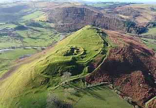
Cefnllys Castle was a medieval spur castle in Radnorshire, Wales. Two successive masonry castles were built on a ridge above the River Ithon known as Castle Bank in the thirteenth century, replacing a wooden motte-and-bailey castle constructed by the Normans nearby. Controlling several communication routes into the highlands of Mid Wales, the castles were strategically important within the Welsh Marches during the High Middle Ages. As the seat of the fiercely contested lordship and cantref of Maelienydd, Cefnllys became a source of friction between Llywelyn ap Gruffudd and Roger Mortimer in the prelude to Edward I's conquest of Wales (1277–1283). Cefnllys was also the site of a borough and medieval town.

<span class="mw-page-title-main">Brycheiniog</span> Kingdom in mid Wales

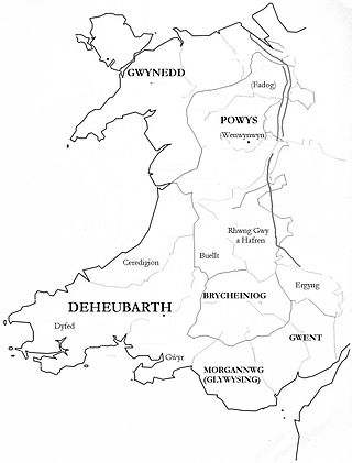
Brycheiniog was an independent kingdom in South Wales in the Early Middle Ages. It often acted as a buffer state between England to the east and the south Welsh kingdom of Deheubarth to the west. It was conquered and pacified by the Normans between 1088 and 1095, though it remained Welsh in character. It was transformed into the Lordship of Brecknock and later formed the southern and larger part of the historic county of Brecknockshire. To its south was the Kingdom of Morgannwg.

<span class="mw-page-title-main">Maelienydd</span>

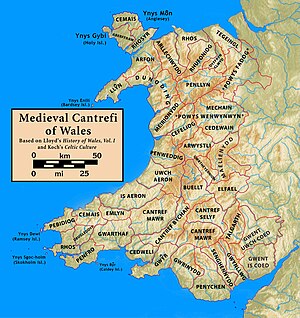
Maelienydd, sometimes spelt Maeliennydd, was a cantref and lordship in east central Wales covering the area from the River Teme to Radnor Forest and the area around Llandrindod Wells. The area, which is mainly upland, is now in Powys. During the Middle Ages it was part of the region known as Rhwng Gwy a Hafren and its administrative centre was at Cefnllys Castle.

<span class="mw-page-title-main">Kingdom of Gwent</span> Kingdom in South Wales

Gwent was a medieval Welsh kingdom, lying between the Rivers Wye and Usk. It existed from the end of Roman rule in Britain in about the 5th century until the Norman invasion of Wales in the 11th century. Along with its neighbour Glywyssing, it seems to have had a great deal of cultural continuity with the earlier Silures, keeping their own courts and diocese separate from the rest of Wales until their conquest by Gruffydd ap Llywelyn. Although it recovered its independence after his death in 1063, Gwent was the first of the Welsh kingdoms to be overrun following the Norman conquest.

<span class="mw-page-title-main">Cwmhir Abbey</span>

Cwmhir Abbey, near Llandrindod Wells in Powys, is a Welsh Cistercian monastery founded in 1176 by Cadwallon ap Madog. A spurious tale was later recorded that the abbey was founded in 1143 by Meredudd ap Maelgwn at Ty-faenor, and then refounded at the present location near the village of Abbeycwmhir in 1176. There does appear to be a site movement from Ty-faenor, but Maredudd ap Maelgwn was prince of Maelienydd in 1215 under Prince Llywelyn ab Iorwerth of Gwynedd, who then controlled the district. The later charter to the abbey in 1215 caused the confusion and led to the belief that Maredudd had founded the abbey in 1143.

Cynllibiwg was evidently a place name in early medieval Wales.

<span class="mw-page-title-main">Gwrtheyrnion</span>

Gwrtheyrnion or Gwerthrynion was a commote in medieval Wales, located in Mid Wales on the north side of the River Wye; its historical centre was Rhayader. It is said to have taken its name from the legendary king Vortigern. For most of the medieval era, it was associated with the cantref of Buellt and then Elfael, small regional kingdoms whose rulers operated independently of other powers. In the Norman era, like the rest of the region between Wye and Severn it came to be dominated by Marcher Lordships.

<span class="mw-page-title-main">Rhwng Gwy a Hafren</span>

Rhwng Gwy a Hafren was a region of medieval Wales, located in the Welsh Marches between Powys to the north and Brycheiniog to the south. It was bounded by the rivers Wye and Severn. It covered about the same territory as Radnorshire, now part of the county of Powys. The region first came into its own in the 9th or 10th centuries, when it was ruled by leaders who operated independently of the surrounding kingdoms. After the Norman invasion, it comprised the central part of the Welsh Marches and was the site of frequent struggles between Welsh and Norman forces.

Cadwallon ap Madog was the son of Madog ab Idnerth who had died in 1140, while Idnerth was a grandson of Elystan Glodrydd who had died in around 1010 and had founded a dynasty in the Middle Marches of Wales, in the area known as Rhwng Gwy a Hafren.

<span class="mw-page-title-main">Elfael</span>

Elfael was one of a number of Welsh cantrefi occupying the region between the River Wye and river Severn, known as Rhwng Gwy a Hafren, in the early Middle Ages. It was divided into two commotes, Is Mynydd and Uwch Mynydd, separated by the chain of hills above Aberedw. In the late medieval period, it was a marcher lordship. However, after the Laws in Wales Act of 1535, it was one of the territorial units which went to make up the county of Radnorshire in 1536.

<span class="mw-page-title-main">Elystan Glodrydd</span> Welsh royal

Elystan Glodrydd, also known as "Æthelstan the Famous" and "The Renowned," was, according to Welsh genealogical tracts, the founder of the fifth Royal Tribe of Wales. He was the Prince of Buellt, and later also of Fferreg ; in the century after his death, Fferreg split into Maelienydd and Elfael

<span class="mw-page-title-main">Cwmdauddwr</span> Human settlement in Wales

Cwmdauddwr is a village in Powys, Wales. It is contiguous with the town of Rhayader on the opposite side of the River Wye. The village is located on the B4518 road linking Rhayader with the Elan Valley Reservoirs.

<span class="mw-page-title-main">Arwystli</span> Medieval Welsh cantref

Arwystli was a cantref in mid Wales in the Middle Ages, located in the headland of the River Severn. It was chiefly associated with the Kingdom of Powys, but was heavily disputed between Powys, Gwynedd, and the Norman Marcher Lords for hundreds of years, and was the scene of many skirmishes between those groups. Like many other cantrefs and subdivisions, it was divided up by the Laws in Wales Acts in the 16th century.

<span class="mw-page-title-main">Duhonw</span>

Duhonw is a rural community in Powys, Wales, to the south of Builth Wells, in the historic county of Breconshire. Covering an area of 4,376 hectares (16.90 sq mi) and including scattered farms and dwellings, it is bounded to its north by the Afon Irfon, to its south by Mynydd Epynt and Banc y Celyn (472m) and to its east the rivers Duhonw and Wye. Llangammarch Wells' is to its west.

Ffernfael ap Tewdwr was a king of Buellt and Gwrtheyrnion in medieval Wales. Little is known of him besides a pedigree included in the 9th-century Historia Brittonum, which makes him a descendant of the ruler Vortigern.

<span class="mw-page-title-main">Cedewain</span>

Cedewain was a medieval cantref in the Kingdom of Powys. It possibly consisted of the commotes (cymydau) of Cynan, Hafren and Uwch Hanes. Other sources give the commotes as Cedewain, Eginlle and Ceri.

<span class="mw-page-title-main">Dinieithon</span>

Dinieithon was a commote within the cantref of Maelienydd, in the medieval region of Rhwng Gwy a Hafren in Wales. It was situated near the modern town of Llandrindod Wells.

Cantref Coch was a cantref associated with the kingdoms of Ergyng, Gwent and the later Kingdom of Glamorgan. Its area is defined as the land between the River Severn and the River Wye, with the Severn Sea as its southern border although its northern border is less certain. Cantref Coch is one of the few medieval cantrefi named by Welsh writers that is not within the modern nation of Wales.

References