Cambrian Mountains

Last updated

View over Llyn Llygad Rheidol from near the summit of Pumlumon Llyn Llygad Rheidol (geograph 2436823).jpg
View over Llyn Llygad Rheidol from near the summit of Pumlumon
View near Cwmystwyth Cwmystwyth - geograph.org.uk - 248196.jpg
View near Cwmystwyth

The Cambrian Mountains (Welsh : Mynyddoedd Cambria, in a narrower sense: Elenydd) are a series of mountain ranges in Wales. The term Cambrian Mountains used to apply to most of the upland of Wales, and comes from the country's Latin name Cambria . Since the 1950s, its application has become increasingly localised to the geographically homogeneous Mid Wales uplands, known in Welsh as Elenydd , which extend from Pumlumon to Radnor Forest in the east and Mynydd Mallaen to the south. This barren and sparsely populated 'wilderness' has been referred to as the Desert of Wales. The area includes the sources of the River Severn and River Wye and was unsuccessfully proposed as a national park in the 1960s and 1970s. The highest point of the range is Plynlimon, at 2,467 feet (752 m).

Contents

The wider, more historic, use of the term also includes Snowdonia in North Wales, and the Brecon Beacons and Black Mountains in South Wales. They range in height up to 3,559 feet (1,085 m) in Snowdonia.

Geology and topography

Cefn Croes wind farm Cefn Croes wind farm - geograph.org.uk - 1616465.jpg
Cefn Croes wind farm

While Snowdonia contains a mix of volcanic rocks and sedimentary rocks of Cambrian and Ordovician age, the mountains of South Wales are mainly Devonian age Old Red Sandstone and Carboniferous Limestone and similarly aged sandstones. The ranges of mid-Wales on the other hand are predominantly formed from Ordovician and Silurian sandstones and mudstones which in many areas outcrop only infrequently so resulting in more rounded grassy hills. The Cambrian Mountains (in the modern sense of the term) are generally less popular with hillwalkers and scramblers than the ranges to their north and south. Since all of Wales' ranges face the predominant westerly air stream coming in from the Atlantic Ocean, they enjoy high levels of rainfall and are the source of numerous rivers, among which the rivers Severn and Wye, which rise on the eastern slopes of Pumlumon, are the largest.[ citation needed ]

Dams and wind farms

The Cambrian Mountains host the Elan Valley Reservoirs and Llyn Brianne reservoir, which provide water for the English West Midlands and for South Wales respectively. They include the Clywedog Reservoir and Nant y Moch Reservoir. Cefn Croes, the site of a controversial wind farm project, is in the Cambrian Mountains, just south of the A44 road between Aberystwyth and Llangurig. [1] [2] [3]

National park proposal

The area was proposed as a national park in 1965 by the National Parks Commission, a precursor body of the Countryside Commission. However, the proposal was opposed by many farmers and local authorities in the area. Formal consultations on the proposal began in 1970, and in 1971 the Countryside Commission proposed a revised boundary for the designation. The proposed area, of 467 square miles (1,210 km2), covered the area of Pumlumon and Elenydd, within an area bounded by the settlements of Machynlleth, Llangurig, Rhayader, Newbridge-on-Wye, Llanwrtyd Wells, Llandovery, Pumsaint, Tregaron, and Devil's Bridge. Despite continuing local opposition, the Countryside Commission published the order designating the area on 15 August 1972, and submitted it to the Secretary of State for Wales, Peter Thomas, for confirmation. [4] [5]

Objections to the proposed designation were then made by all five county councils, 5 of the 7 district councils, 5 parish councils, the National Farmers Union, the Country Landowners Association, Plaid Cymru, the Campaign for the Protection of Rural Wales and others. Support for the designation was expressed by the Ramblers Association, Youth Hostels Association, and Cyclists' Touring Club. In July 1973, the Secretary of State announced the decision not to proceed with the designation because of "massive evidence of objections", and also rejected a call to hold a public inquiry. This was the first time such a recommendation on national park designation had not been accepted. [5]

Principal summits

This list confines itself to the more geographically restricted area referred to above.

See also

Related Research Articles

<span class="mw-page-title-main">Brecon Beacons</span> Region and national park in south Wales

The Brecon Beacons, or Bannau Brycheiniog ( ), is a mountainous region and national park in Wales. The name 'Brecon Beacons' was originally applied only to the mountain range south of Brecon, Powys, which is now also known as the Central Beacons. The range includes South Wales' highest mountain, Pen y Fan, its twin summit Corn Du, and Craig Gwaun Taf, which are the three highest peaks in the range.

<span class="mw-page-title-main">Ceredigion</span> County in Wales

Ceredigion, historically Cardiganshire, is a county in the west of Wales. It borders Gwynedd across the Dyfi estuary to the north, Powys to the east, Carmarthenshire and Pembrokeshire to the south, and the Irish Sea to the west. Aberystwyth is the largest settlement and, together with Aberaeron, is an administrative centre of Ceredigion County Council.

<span class="mw-page-title-main">Rhinogydd</span> Mountain range near Harlech, Wales

The Rhinogydd are a range of mountains located east of Harlech in North Wales. The name Rhinogydd derives from the names of two of the more famous peaks, Rhinog Fawr and Rhinog Fach, although the greatest elevation in the range is reached by Y Llethr, 756 m.
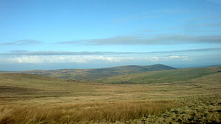
<span class="mw-page-title-main">Plynlimon</span> Mountain in Wales

Plynlimon, also spelled as Pumlumon in Welsh, is the highest point of the Cambrian Mountains in Wales, and the highest point in Mid Wales. It is a massif that dominates the surrounding countryside and is the highest point of Ceredigion.

<span class="mw-page-title-main">Glyderau</span> Mountain group in Wales

The Glyderau are a mountain group in Snowdonia, North Wales. The name derives from the highest peaks in the range, Glyder Fawr and Glyder Fach. According to Sir Ifor Williams, the word "Glyder" derives from the Welsh word "Cludair", meaning a heap of stones.

<span class="mw-page-title-main">Glyder Fawr</span> Mountain in Snowdonia, Wales

Glyder Fawr is a mountain in Snowdonia, Wales, the highest peak in the Glyderau range at just over 1,000 metres, having had its height recalculated in 2010 using GPS. It is the fifth-highest mountain in Wales and has several walking and scrambling routes leading to its summit. According to Sir Ifor Williams, the word "Glyder" derives from the Welsh word "Gludair", meaning a heap of stones.

<span class="mw-page-title-main">Black Mountains, Wales</span> Region of hills in Wales and England

The Black Mountains are a group of hills spread across parts of Powys and Monmouthshire in southeast Wales, and extending across the England–Wales border into Herefordshire. They are the easternmost of the four ranges of hills that comprise the Brecon Beacons National Park, and are frequently confused with the westernmost, which is known as the Black Mountain. The Black Mountains may be roughly defined as those hills contained within a triangle defined by the towns of Abergavenny in the southeast, Hay-on-Wye in the north and the village of Llangors in the west. Other gateway towns to the Black Mountains include Talgarth and Crickhowell. The range of hills is well known to walkers and ramblers for the ease of access and views from the many ridge trails, such as that on the Black Hill (Herefordshire) at the eastern edge of the massif. The range includes the highest public road in Wales at Gospel Pass, and the highest point in southern England at Black Mountain.

<span class="mw-page-title-main">Waun Fach</span> Mountain in Wales

Waun Fach is, with a summit height of 811 metres (2,661 ft), the highest mountain in the Black Mountains in south-eastern Wales. It is one of the three Marilyns over 600 m that make up the range, the others being Black Mountain and Mynydd Troed. To the north Rhos Fawr and the Radnor Forest can be seen. It is the third highest mountain in Britain south of Snowdonia. It is situated at the head of the Grwyne Fechan valley, above and to the west of the Grwyne Fawr reservoir. It has an undistinguished rounded summit. The nearby tops on the ridge, Pen Trumau and Pen y Gadair Fawr, although lower, are very much more recognisable.

<span class="mw-page-title-main">Cefn Croes Wind Farm</span>

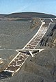
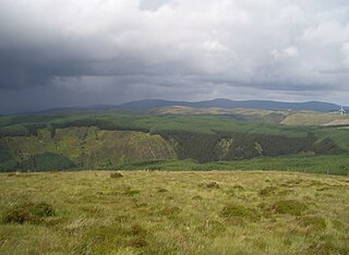
Cefn Croes is a wind farm in Ceredigion, Wales. It is located in the Cambrian Mountains on Cefn Croes mountain, 573m (1,880 ft) south of the A44 road between Aberystwyth and Llangurig, in west Wales. The construction of the wind farm commenced in February 2004, and was completed in the spring of 2005 when the 39 wind turbines started producing electricity. The maximum installed nameplate capacity is 58.5 MW.

Pen Pumlumon Llygad-bychan is a subsidiary summit of Pen Pumlumon Fawr and the third highest summit on the Plynlimon massif, a part of the Cambrian Mountains in the county of Ceredigion, Wales. It is not named on Ordnance Survey walking maps.

<span class="mw-page-title-main">Pumlumon Fach</span>

Pumlumon Fach is a top of Pen Pumlumon Fawr on the Plynlimon massif, a part of the Cambrian Mountains in the county of Ceredigion, Wales. It lies on small ridge heading north-west from the summit of Pen Pumlumon Fawr.

<span class="mw-page-title-main">Y Garn (Plynlimon)</span>

Y Garn is a subsidiary summit of Pen Pumlumon Fawr and the fourth highest peak on the Plynlimon massif, a part of the Cambrian Mountains in the county of Ceredigion, Wales.

Pen Pumlumon Arwystli is the second highest summit on the Plynlimon massif, a part of the Cambrian Mountains in the county of Ceredigion, Wales.

<span class="mw-page-title-main">Cambrian Way</span> Long distance footpath in Wales

The Cambrian Way, initially an unofficial long distance footpath in Wales running from Cardiff to Conwy, was officially recognised in 2019. Primarily a mountain walk, it runs over many of the highest and most scenically beautiful areas of Wales. It was pioneered in the 1960s and 1970s by walker Tony Drake, who later produced a guidebook of the walk.

<span class="mw-page-title-main">Foel-goch</span>

Foel-goch is a mountain in Snowdonia, north-west Wales, and forms part of the Glyderau range, in Gwynedd. It lies in between Y Garn and Mynydd Perfedd.

<span class="mw-page-title-main">Pen y Garn</span> Mountain (611m) in Ceredigion

Pen y Garn is a mountain in the Cambrian Mountains, Mid Wales standing at 611 metres above sea level.
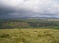
<span class="mw-page-title-main">Elenydd</span> Area of Mid Wales

Elenydd is an upland area of Mid Wales, extending across parts of northern and eastern Ceredigion and Powys between Aberystwyth and Rhayader. Elenydd is also a name given to the medieval commote of Cwmwd Deuddwr which covered approximately the same area.

<span class="mw-page-title-main">Llangurig branch</span>

The Llangurig branch was a part of a proposed scheme by the Manchester and Milford Railway (M&MR) to connect industrialised Northwest England with the West Wales deep water port of Milford Haven. After various financial and construction difficulties, the 1.5 miles (2.4 km) of the Llangurig branch is noted as being the shortest lived working branch line in the United Kingdom, receiving only one train.

Y Glog or Draws Drum is a mountain situated in Ceredigion, Wales. It stands at an elevation of 574 metres above sea level and is located a few miles south of Pumlumon, north of Pen y Garn, and just south of the A44 road. The mountain is classified as a HuMP, denoting its prominence. It is situated in a region characterized by desolate moorland, which is home to the Cefn Croes Wind Farm and the nearby small lakes known as Llynoedd Ieuan.

References

  1. "Cefn Croes Wind Project". Power Technology. 15 June 2011. Retrieved 28 March 2012.
  2. "Cefn Croes is close to Aberystwyth. - Image". Power Technology. 15 June 2011. Archived from the original on 30 September 2017. Retrieved 28 March 2012.
  3. "Cefn Croes Wind Farm - Official Campaign website". Users.globalnet.co.uk. 20 September 2003. Archived from the original on 15 March 2012. Retrieved 28 March 2012.
  4. "Cambrian Mountains National Park story". Cambrian-mountains.co.uk. 6 March 2011. Archived from the original on 1 April 2012. Retrieved 28 March 2012.
  5. 1 2 Cambrian Mountains Society: National Park Timeline 1872-1973 Archived 2012-04-01 at the Wayback Machine . Accessed 29 March 2012

52°25′N3°30′W / 52.417°N 3.500°W / 52.417; -3.500