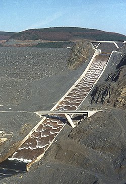
Llyn Brianne

Last updated

Llyn Brianne
Llyn Brianne Reservoir.jpg
The Llyn Brianne rock-fill dam
Powys UK relief location map.jpg
Red pog.svg
Llyn Brianne
Location Wales
Coordinates 52°8′N3°45′W / 52.133°N 3.750°W / 52.133; -3.750
Type reservoir
Basin  countriesUnited Kingdom

Llyn Brianne is a man-made lake or reservoir in the headwaters of the River Towy in Wales.

Contents

Looking east over the reservoir Rhandirmwyn Reservoir - geograph.org.uk - 59087.jpg
Looking east over the reservoir
The Llyn Brianne spillway after its first fill at commissioning Llyn Brianne spillway.jpg
The Llyn Brianne spillway after its first fill at commissioning

Construction

The reservoir was constructed by Wimpey Construction in the late 1960s and early 1970s [1] in order to regulate the flow in the Towy to support large potable water abstraction at Nantgaredig in the lower reaches of the river near Carmarthen; providing water to the Felindre water treatment works. The treated water is piped to a large area of South Wales which includes Swansea and Neath and the western periphery of Cardiff.

Structure

The dam is of crushed rock, larger rock and clay; all materials having been obtained in the area. In essence, it is a constructed mountain blocking the valley. The clay was harvested higher up the valley near Soar y mynydd chapel closer to Tregaron. Much of the rock was harvested at the site. An on-site stone-crusher was used to reduce larger rocks to the various sizes required. A round-the-clock labouring system enabled its completion almost two years ahead of schedule.

Fish conservation

Because of the importance of the River Towy salmon and trout fisheries, special protective measures were incorporated into the construction of the reservoir including a smolt trap and a restocking programme using artificially raised parr. Releases of water from the dam tend to be very cold and are also blamed by anglers for a reduction in the quality of the fishery.

Hydroelectric scheme

The spillway of the dam is a notable tourist attraction when the reservoir is spilling. The dam is the UK's tallest, standing at a height of 300 ft (91 m). In 1996 the reservoir spillway was increased by 1 metre in height and a hydro electric generating station was added at the base of the dam. When all three turbines are working, it generates 4.60 megawatts of electricity. [2]

Several flooded houses are submerged beneath the reservoir. Before the water level was raised, it was possible to walk to Fannog farmhouse; a "For Sale" sign was once erected on it. It is still possible to see the roof when the water level is low.

Activities permitted on the reservoir

Since 19 April 2011 the reservoir has been governed by a set of bylaws known as the 'Dwr Cymru Cyf, Llyn Brianne Bylaws 2010' which are enforceable under The Water Industry Acts 1991–2003. These bylaws (among other things) specifically forbid "bathing, diving, and swimming in the reservoir, as well as using any boat (kayak, canoe or any other vessel including a ski-jet) in on or over any part of the waterway". The bylaws also forbid angling without a permit issued by Welsh Water. [3]

The spillway has previously been used by kayakers to slide down while the water is in flood and following a peak of media interest in this activity around 2008 Welsh Water issued a statement, calling the practice "dangerous" and stating that such activities were banned at the reservoir. According to a BBC report also from 2008, Richard Harvey from the Welsh Canoeing Association said he could not comment on the group involved, the locality or the legality of their activity but he did say he was aware the slipway had been used by kayakers for about 20 years. [4]

Related Research Articles

<span class="mw-page-title-main">Dartmouth Dam</span> Dam in Victoria

Dartmouth Dam is a large rock-fill embankment dam with an uncontrolled chute spillway across the Mitta Mitta, Gibbo and Dart rivers, the Morass Creek and a number of small tributaries. The dam is located near Mount Bogong in the north-east of the Australian state of Victoria. The dam's purpose includes irrigation, the generation of hydro-electric power, water supply and conservation. The impounded reservoir is called Dartmouth Reservoir, sometimes called Lake Dartmouth. The Dartmouth Power Station, a hydro-electric power station that generates power to the national grid, is located near the dam wall.

<span class="mw-page-title-main">River Towy</span> River in Wales

The River Towy is one of the longest rivers flowing entirely within Wales. Its total length is 120 km (75 mi). It is noted for its sea trout and salmon fishing.

<span class="mw-page-title-main">Afon Tryweryn</span> River in the United Kingdom

The Tryweryn is a river in the north of Wales which starts at Llyn Tryweryn in the Snowdonia National Park and after 19 kilometres (12 mi) joins the river Dee at Bala. One of the main tributaries of the Dee, it was dammed in 1965 to form Llyn Celyn. The Tryweryn flooding forcibly removed residents of the village of Capel Celyn despite popular and political opposition in Wales. The resulting graffiti "Cofiwch Dryweryn" near Llanrhystud became and remains a popular icon of Welsh feeling. Water is stored in Llyn Celyn in winter when flows are high, and released over the summer to maintain the flow in the Dee (water from the Dee is used as the water supply for large areas of north-east Wales, and for the Wirral and much of Liverpool in England.

<span class="mw-page-title-main">River Dwyryd</span> River in Gwynedd, Wales

The River Dwyryd, is a river in Gwynedd, Wales which flows principally westwards; draining to the sea into Tremadog Bay, south of Porthmadog.

<span class="mw-page-title-main">Wyangala Dam</span> Dam in New South Wales, Australia

Wyangala Dam is a major gated rock fill with clay core embankment and gravity dam with eight radial gates and a concrete chute spillway across the Lachlan River, located in the south-western slopes region of New South Wales, Australia. The dam's purpose includes flood mitigation, hydro-power, irrigation, water supply and conservation. The impounded reservoir is called Lake Wyangala.

<span class="mw-page-title-main">Llyn Celyn</span> Artificial lake near Bala in Gwynedd, north Wales

Llyn Celyn is a reservoir constructed between 1960 and 1965 including the highly controversial Tryweryn flooding in the valley of the River Tryweryn in Gwynedd, Wales. This included the forcible removal of the Capel Celyn village residents despite protest and opposition of Welsh MPs.

<span class="mw-page-title-main">Reservoir</span> Storage space for water

A reservoir is an enlarged lake behind a dam. Such a dam may be either artificial, usually built to store fresh water, or it may be a natural formation.

<span class="mw-page-title-main">Blowering Dam</span> Dam in Snowy Mountains, New South Wales

The Blowering Dam is a major ungated rock fill with clay core embankment dam with concrete chute spillway impounding a reservoir under the same name. It is located on the Tumut River upstream of Tumut in the Snowy Mountains region of New South Wales, Australia. Purposes for the dam include flood mitigation, hydro-power, irrigation, water supply and conservation. The dam is part of the Snowy Mountains Scheme, a vast hydroelectricity and irrigation complex constructed in south-east Australia between 1949 and 1974 and now run by Snowy Hydro.

<span class="mw-page-title-main">Moogerah Dam</span> Dam in South East Queensland

The Moogerah Dam is a mass concrete double curvature arch dam with an un-gated spillway across Reynolds Creek in South East Queensland, Australia, now within the locality of Moogerah in the Scenic Rim Region. The main purposes of the dam are for irrigation in the Reynolds Creek district and for supply of potable water to Warrill Creek and farmers in the Warrill Valley. The impounded reservoir is called Lake Moogerah.

<span class="mw-page-title-main">Clywedog Reservoir</span> Reservoir in the United Kingdom

The Clywedog Reservoir is a reservoir near Llanidloes, Wales on the head-waters of the River Severn. The construction of the reservoir was enabled by an Act of Parliament which asserted that "At certain times the flow of water in the river is inadequate ... unless that flow were regulated so as to ensure that at those times water in addition to the natural flow will flow down the river."

<span class="mw-page-title-main">North Pine Dam</span> Dam in South East Queensland

The North Pine Dam is a mass concrete gravity dam with earth-fill embankments on abutments with a gated spillway across the North Pine River that is located in the South East region of Queensland, Australia. The main purpose of the dam is for supply of potable water for the Moreton Bay region and Brisbane's northern suburbs. The impounded reservoir is called Lake Samsonvale.

<span class="mw-page-title-main">Embankment dam</span> Type of artificial dam

An embankment dam is a large artificial dam. It is typically created by the placement and compaction of a complex semi-plastic mound of various compositions of soil or rock. It has a semi-pervious waterproof natural covering for its surface and a dense, impervious core. This makes the dam impervious to surface or seepage erosion. Such a dam is composed of fragmented independent material particles. The friction and interaction of particles binds the particles together into a stable mass rather than by the use of a cementing substance.

<span class="mw-page-title-main">Chaffey Dam</span> Dam in New South Wales, Australia

Chaffey Dam is a minor ungated rock fill with clay core embankment dam with an uncontrolled morning glory spillway across the Peel River, located upstream of the city of Tamworth, in the New England region of New South Wales, Australia. The dam's purpose includes flood mitigation, irrigation, water supply, and water conservation.

The Borumba Dam is a rock-fill embankment dam with an un-gated spillway located across the Yabba Creek, a tributary of the Mary River, in the Wide Bay–Burnett region of Queensland, Australia. The main purposes of the dam are for irrigation and potable water supply. The resultant impounded reservoir is called Lake Borumba.

<span class="mw-page-title-main">Wappa Dam</span> Dam in South East Queensland

The Wappa Dam is a mass concrete gravity arch dam with earth-fill abutments and an un-gated spillway across the South Maroochy River that is located in the South East region of Queensland, Australia. The main purpose of the dam is for supply of potable water for the Sunshine Coast region. The impounded reservoir is also called Wappa Dam. The dam and most of the reservoir are within Kiamba with the most northerly part of the reservoir in Cooloolabin, both in the Sunshine Coast Region.

<span class="mw-page-title-main">Enoggera Dam</span> Dam in South East Queensland

The Enoggera Dam is a heritage-listed dam, which is located within the outer, western suburb of Enoggera Reservoir, in Brisbane, Queensland, Australia.

<span class="mw-page-title-main">Maroondah Dam</span> Dam in near Healesville Victoria

The Maroondah Dam is a rock-foundation concrete gravity dam with an uncontrolled rock-chute spillway across the Watts River, located in the Central region of the Australian state of Victoria. The storage created by the dam is called Maroondah Reservoir. The principal purpose of the dam and its reservoir is to supply potable water for Greater Metropolitan Melbourne.

<span class="mw-page-title-main">Toonumbar Dam</span> Dam in Northern Rivers, New South Wales

Toonumbar Dam is a minor ungated rock fill with clay core embankment dam with a concrete chute spillway across the Iron Pot Creek north-west of Casino in the Northern Rivers region of New South Wales, Australia. The dam's purpose includes hydro-power, irrigation, water supply, and conservation. The impounded reservoir is called Lake Toonumbar.

The Camddwr is a significant right-bank tributary of the River Towy in the eastern part of Ceredigion, mid Wales. It rises on the undulating plateau east of Garn Gron (52.2253°N 3.8247°W) and flows in a generally south-southeasterly direction into Llyn Brianne, a reservoir formed by the damming of the upper Towy, (52.1574°N 3.7656°W). A chapel at Soar y mynydd beside the river is often mentioned as being the most isolated in Wales.

There are a large number of reservoirs in Wales reflecting the need for the supply of water for both industry and for consumption, both within the country itself and in neighbouring England. A number also provide hydroelectricity and many old reservoirs also provided motive power for industries, especially for the processing of minerals such as metal ores and slate.

References

  1. Engineering Timelines
  2. Our operations Archived 2013-10-14 at the Wayback Machine Infinis
  3. "Lynn Brianne Bylaws" (PDF). Welsh Water. 19 April 2011. Retrieved 18 February 2020.
  4. "Kayakers' 300ft dam drop attacked". BBC. 18 November 2008. Retrieved 18 November 2008.

Further reading