Cambrian Way

Last updated

Cambrian Way (Taith Cambria)
Craig Maesglase near Dinas Mawddwy.JPG
View from the Cambrian Way, near Dinas Mawddwy, Gwynedd
Length298 miles (480 km)
LocationWales, United Kingdom
DesignationUnofficial Long Distance Trail
Trailheads Cardiff Castle, South Wales Coast
Conwy Castle, North Wales Coast
UseHiking
Highest point Snowdon, 1,085 m (3,560 ft)
DifficultyStrenuous
SeasonSummer
SightsMountain scenery
Hazards Severe weather

The Cambrian Way, [1] initially an unofficial long distance footpath in Wales (or Cambria) running from Cardiff to Conwy, was officially recognised in 2019. [2] Primarily a mountain walk, it runs over many of the highest and most scenically beautiful areas of Wales. It was pioneered in the 1960s and 1970s by walker Tony Drake, who later produced a guidebook of the walk.

Contents

Initially, the official recognition relates only to the approval of national park authorities and most local authorities involved in the waymarking of the route in lowland areas and this is expected to be completed in 2020. This is not as extensive as the waymarking of National Trails and does not include mountain areas where waymarking is not generally permitted. Following negotiation, the whole route is now marked on the 1:25,000 Ordnance Survey map.

Distance

The main route originally ran for 291 miles (468 km), with approximately 78,025 feet (23,782 m) of ascent using the latest digital measurements from the Ordnance Survey's 'OS Maps' website. Previous estimates were 275 miles (443 km) and 60,795 feet (18,530 m) of ascent using paper maps and counting contours in 2008, and 288 miles (463 km) and 67,100 feet (20,500 m) of ascent using Ordnance Survey's 'Getamap' website in 2012. The latest measurements of ascent take into account the extra ascent of undulations between plotted points and are, therefore, considerably greater than previous estimates and probably more accurate, though they are still subject to a margin of error.

Following a number of changes to the route that are incorporated in the latest Cicerone guide, the main route has increased to approximately 479 km (298 miles) with a total ascent of 22,460 m (73,700 ft).

The route

The Cambrian Way is a mountain walking route from Cardiff to Conwy traversing much of the highest, wildest and most scenically beautiful parts of Wales. It was pioneered by the late Anthony John Drake MBE (Tony Drake) (25 January 1925 – 7 March 2012). Originally conceived in 1967 with the intention of becoming a National Trail, the proposals floundered because of insurmountable opposition from landowners, farmers, county councils, national park authorities and the British Mountaineering Council. Rather than abandoning the project altogether, Drake realised that the route could be promoted as an unofficial walk provided that it followed a route along established rights of way or where the public had traditionally been allowed access, so in 1984 he published the first edition of his guidebook Cambrian Way – A Mountain Connoisseur's Walk. Further updated editions of the guidebook continued to be published, his last one being the 6th edition published in 2008. He continued unsuccessfully to campaign for official recognition of the walk throughout the rest of his life until ill health intervened a few years before his death in 2012. The 7th edition of the guide, updated by the newly formed Cambrian Way Trust, was in 2016. The route is only partially waymarked and requires advanced map reading and navigational experience in certain sections. The route is wholly within Wales, unlike the Offa's Dyke Path, which follows the Wales-England border. Accommodation is scarce along some parts of the walk, so diversions, some quite long, are needed unless a tent and provisions are carried.

In 2015, at the time that the Cambrian Way Trust was formed, working groups from Ramblers Cymru were in the process of surveying the whole of the route and throughout this process a number of route changes were agreed between the Trust and working groups to avoid some road walking and to take advantage of the most scenic routes. This was done in collaboration with the Brecon Beacons National Park Authority and the Snowdonia National Park Authority who made a number of suggestions of their own, in particular regarding bad weather alternative routes over the Rhinog Mountains. These changes were then incorporated in a new guidebook Walking The Cambrian Way, published in July 2019 by Cicerone.

It traverses Wales from Cardiff Castle near the south coast to Conwy Castle on the north coast and is purposely routed over the highest upland and mountainous terrain including the Black Mountains, Central Beacons and Black Mountain (all within the Brecon Beacons National Park), the Cambrian Mountains, Cadair Idris, and Snowdon.

Southern section

The starting point of the route is at Cardiff Castle, chosen for its good transport links and in order for the walk to become a coast to coast route from South Wales to North Wales. Despite the first day of the walk lacking any mountains, it follows a pleasant ridgeway walk from Cwm Nofydd north of Rhiwbina along the Cefn Onn Ridge to Rudry before joining the open common ridges bordering on the Vale of Usk. The Brecon Beacons National Park is entered just north of Pontypool and open moorland followed to the Blorenge, thence by steep descent to the town of Abergavenny. After ascending Sugar Loaf a horseshoe shaped route follows the finest ridges of the Black Mountains via Capel-y-ffin to Crickhowell. There follows an east to west traverse of the elevated ridges of the Brecon Beacons including Pen y Fan, the highest point in South Wales at 886 m (2906 ft). The moorland continues to the Black Mountain range, also known as the Carmarthen Fans, the largest common in Wales, before dropping to Llanddeusant and field country to Llandovery.

Central section

From Llandovery, the route follows the attractive River Towy valley at Rhandirmwyn, a once busy metal mining area. The remote path up the Doethie valley leads to the Ty'n-y-cornel Youth Hostel, the most isolated hostel in Wales and officially a Dark Skies site. The route follows the western side of the wild moorland and forest area known as the Elenydd, which includes the gathering grounds of the Elan Valley Reservoirs which serve Birmingham. After rambling country around Devil's Bridge and Ponterwyd, the route crosses the exposed massif of Plynlimon, with opportunities to view the sources of the River Severn and the River Wye. The hamlet of Dylife, once the workplace of 2,000 miners, now only has a few houses and the Star Inn. A mixture of forest and sheep grazing land leads through the windfarm on Mynydd Cemmaes and so to Mallwyd and Dinas Mawddwy.

Northern section

From Dinas Mawddwy the route enters its northern and arguably toughest section through the Snowdonia National Park, crossing Cadair Idris before entering Barmouth before tackling the Rhinog Mountains which, given their remoteness and the rugged nature of walking, are the highlight of the whole route. The lack of accommodation and the slow going and distance means that this section is the most challenging for the walker. From Maentwrog the route goes over Cnicht to Beddgelert before going over the highest summit in Wales, Snowdon. A further steeper ascent takes the hiker over Glyder Fawr and Glyder Fach into the Ogwen Valley, before the long final stage across the Carneddau to the finish of the route at Conwy Castle.

History of the walk

After some involvement in planning sections of the Cotswold Way and Offa's Dyke Path in the 1950s, Tony Drake did some preliminary planning for a route from Gloucester to Snowdon via the Black Mountains, Brecon Beacons and Plynlimon. It was not until 1967 that it occurred to him to wonder why no one had proposed a long distance route over the principal mountains of Wales. The idea received enthusiastic response from the Ramblers' Association (now The Ramblers) and the Youth Hostels Association (England & Wales).

In 1968 the Cambrian Way Committee [3] was formed and chaired by Drake. Groups from several different organisations, Ramblers, YHA, Brecon Beacons and Voluntary Wardens Association, were allocated sections to survey. The British Mountaineering Council was offered the Caernarvonshire section but turned out to be hostile to the whole concept. There was some disagreement as to which route should be taken in several places and where the start and finish should be. In the three subsequent meetings a number of compromises were made, some of them for safety reasons, but there were still divided opinions on parts of the route.

The Countryside Commission had the responsibility for making recommendations to the Secretaries of State for the Environment or for Wales for the creation of long distance paths (now called National Trails), under provisions of the National Parks & Access to the Countryside Act 1949 (since 1991 these duties in Wales have been taken over by the Countryside Council for Wales). Routes approved by the Secretary of State become the responsibility of the local authorities to create with a 100% grant from national funds. New rights of way can be created by agreement or compulsorily by creation order. The commission from the beginning made encouraging noises and first mentioned the Cambrian Way in its annual report for 1968. However, it was made clear that only restricted resources and the route was still "under consideration" for a number of years.

In April 1976 the Commission approved the Cambrian Way project in principle and in September 1977 started official consultations on the basis of a map showing both the Cambrian Way Committee's route and the Commission's Preferred Route which differed in many respects. All the principal summits in Snowdonia were omitted. The route was to go over the Aran Mountains and the Arenig Mountains instead of the Rhinog Mountains and Cadair Idris. The crossover from Black Mountains to Brecon Beacons was to be via Mynydd Llangorse.

Following opposition from many quarters, the commission issued another line in January 1980 called a Consultation Route. This time the Cambrian Way Committee's route was not shown on the map, though the new route was closer to it than the 1977 line. Snowdon was included but still not the ridge of the Carneddau, Cadair Idris was included and a route to the seaward side of the Rhinog Mountains instead of a route over the Aran Mountains, where in the meantime an access row had blown up. The Black Mountains were omitted altogether following pressure from the Brecon Beacons National Park committee.

In 1982 a compromise route called the "Consultation Route" was put forward, but strong objections were encountered from several bodies and it became clear that many more compromises would be needed to get approval. The initial enthusiasm of the Countryside Commission waned and the proposals were abandoned. With his hopes of official recognition shattered, Drake decided to publish his first guidebook of his unofficial route in 1984, with much greater freedom to define a route of his own preference. This was not the very first book of the Cambrian Way to be published, as he was pipped to the post by Richard Sale with his book A Cambrian Way, though this took a different route in some places and was not designed as a compact guidebook to be carried on a walk, meaning that Drake's book became the definitive guide to the Cambrian Way.

Future of the Cambrian Way

In accordance with a codicil to Tony Drake's will, the copyright of the guidebook and Cambrian Way website were left to a trust, which was to be formed by the three people who had been helping out during the latter years of his life. It was not until 1 October 2015 that the trust was officially formed, by which time one of the original helpers had died and another had expressed his wish to resign, leaving just one of the three named in the codicil remaining. However, Tony Drake also left a legacy to The Ramblers for maintaining and improving the Cambrian Way, and the working group that was set up to oversee this included members who were willing to become trustees of the Cambrian Way Trust.

Cambrian Way Trust

The Cambrian Way Trust currently has four Trustees and its purposes are:

(1) The promotion of the Cambrian Way as a long distance walk as a benefit to the public.

(2) To monitor the Cambrian Way route for improvements obstacles and variations.

(3) Directly or through the making of grants and/or the persuasion of others to improve maintain and repair the Cambrian Way.

(4) The publication of future versions of the Cambrian Way as a guide to walkers and to maintain improve and adapt The Cambrian Way Website so as to improve the usefulness of the site to walkers and sponsors.

(5) To deal with such other matters connected or related to the provision of the Cambrian Way as a long distance walk as the Trustees think fit.

The working groups

These groups consist mostly of members of Ramblers Cymru, the Welsh section of The Ramblers. Task groups from local areas will undertake work in their own locality, coordinated by the working group. Their objectives are:

(1) To survey the route and its variants to establish the condition of the route including any stiles, fences and gates.

(2) To establish where waymarking would be beneficial and appropriate and to seek permission from landowners to allow such waymarks. It is not considered appropriate to do so over mountain tops, but it would be beneficial at lower levels through farmland where paths are not always easy to follow.

(3) To report any obstacles along the route and suggest any alternatives to the route that it is considered would improve it for any reason. By consultation with the Cambrian Way Trust, decisions can be made as to whether these should be incorporated into future editions of the guidebook and promoted on the Cambrian Way website.

(4) To liaise with landowners, County Councils and National Park Authorities as to what action should be taken to rectify any problems and/or improve the route.

(5) To liaise with existing accommodation providers and campsites as listed in the guidebook and to seek addition establishments, particularly in remote areas.

(6) To promote the Cambrian Way by whatever means are considered appropriate through The Ramblers and other organisations.

In August 2019 Oliver Wicks from Ramblers Cymru said, "We have currently completed waymarking the route up to and including the Brecon Beacons and hope to have completed the entire route by the new year." In June 2022 the Ordnance Survey placed the route of the Cambrian Way on their maps. [2] A new guide to the Cambrian Way was published in July 2019. [4]

Related Research Articles

<span class="mw-page-title-main">Snowdonia</span> Mountainous region and national park in north Wales

Snowdonia, or Eryri, is a mountainous region and national park in northwestern Wales. It contains all 15 mountains in Wales over 3000 feet high, including the country's highest, Snowdon, which is 1,085 metres (3,560 ft) tall. These peaks are all part of the Snowdon, Glyderau, and Carneddau ranges in the north of the region. The shorter Moelwynion and Moel Hebog ranges lie immediately to the south.

<span class="mw-page-title-main">Snowdon</span> Highest mountain in Wales

Snowdon, or Yr Wyddfa, is the highest mountain in Wales, at an elevation of 1,085 metres (3,560 ft) above sea level, and the highest point in the British Isles outside the Scottish Highlands. It is located in Snowdonia National Park in Gwynedd.

<span class="mw-page-title-main">A470 road</span> Major long-distance road in Wales

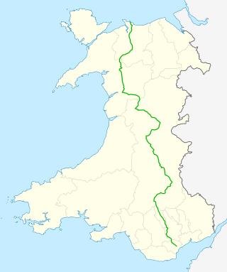
The A470 is a trunk road in Wales. It is the country's longest road at 186 miles (299 km) and links the capital Cardiff on the south coast to Llandudno on the north coast. While previously one had to navigate the narrow roads of Llanidloes and Dolgellau, both these market towns are now bypassed due to extensive road modernisation. The 26 miles (42 km) from Cardiff Bay to Merthyr Tydfil are mainly dual carriageway, but most of the route from north of Merthyr to Llandudno is single carriageway.

<span class="mw-page-title-main">Rhinogydd</span> Mountain range near Harlech, Wales

The Rhinogydd are a range of mountains located east of Harlech in North Wales. The name Rhinogydd derives from the names of two of the more famous peaks, Rhinog Fawr and Rhinog Fach, although the greatest elevation in the range is reached by Y Llethr, 756 m.

<span class="mw-page-title-main">Glyder Fawr</span> Mountain in Snowdonia, Wales

Glyder Fawr is a mountain in Snowdonia, Wales, the highest peak in the Glyderau range at just over 1,000 metres, having had its height recalculated in 2010 using GPS. It is the fifth-highest mountain in Wales and has several walking and scrambling routes leading to its summit. According to Sir Ifor Williams, the word "Glyder" derives from the Welsh word "Gludair", meaning a heap of stones.

<span class="mw-page-title-main">Pen y Fan</span> Welsh mountain peak of the Brecon Beacons, Powys

Pen y Fan is the highest peak in South Wales, situated in Brecon Beacons National Park. At 886 metres (2,907 ft) above sea-level, it is also the highest British peak south of Cadair Idris in Snowdonia. It is the highest point of the historic county of Brecknockshire. The twin summits of Pen y Fan and Corn Du at 873 metres (2,864 ft) were formerly referred to as Cadair Arthur or 'Arthur's Seat'.

<span class="mw-page-title-main">Aran Fawddwy</span>

Aran Fawddwy is a mountain in southern Snowdonia, Wales, United Kingdom. It is the highest point of the historic county of Merionethshire. It is the highest peak in the Aran mountain range, the only peak in Wales outside North Snowdonia above 900m, and higher than anywhere in the United Kingdom outside Northern Snowdonia, the Scottish Highlands and the Lake District. The nearest small settlements to the mountain are Dinas Mawddwy to the south, Llanymawddwy to the southeast, Llanuwchllyn on the shores of Bala Lake to the north, and Rhydymain to the west. The nearest settlements with around 2,000 people are Bala and Dolgellau. On the eastern slopes of Aran Fawddwy is the small lake named Creiglyn Dyfi, the source of the River Dyfi. Its sister peak is Aran Benllyn at 885 metres (2,904 ft). There is also a middle peak: Erw y Ddafad-ddu.

<span class="mw-page-title-main">Cadair Idris</span> Mountain in Wales

Cadair Idris or Cader Idris is a mountain in the Meirionnydd area of Gwynedd, Wales. It lies at the southern end of the Snowdonia National Park near the town of Dolgellau. The peak, which is one of the most popular in Wales for walkers and hikers, is composed largely of Ordovician igneous rocks, with classic glacial erosion features such as cwms, moraines, striated rocks, and roches moutonnées.

<span class="mw-page-title-main">Cadair Berwyn</span> Mountain (832m) in Powys, Wales

Cadair Berwyn, Cader Berwyn or Craig Uchaf is a mountain summit in north-east Wales with a height of 832 metres (2,730 ft) above sea level. It is the highest point in the Berwyn range, the highest in North East Wales and the highest significant summit in Wales outside the National Parks. Cadair Berwyn and Foel Cedig to the west are the two Marilyns that form the Berwyn range. The undulating plateau of the range also includes a large number of other summits above 2,000 feet (610 m), including satellite summits of Cadair Berwyn and many which are classed as Nuttalls.

<span class="mw-page-title-main">National parks of Wales</span> Area of landscape in Wales

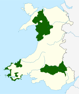
The national parks of Wales are managed areas of outstanding landscape in Wales, United Kingdom where some forms of development are restricted to preserve the landscape and natural environment. Together, they cover 20% of the land surface of Wales and have a resident population of over 80,000 people. Each National Park Authority is a free-standing body within the local government framework.

<span class="mw-page-title-main">Arenig Fawr</span>

Arenig Fawr is a mountain in Snowdonia, North Wales, close to Llyn Celyn reservoir, alongside the A4212 between Trawsfynydd and Bala.

<span class="mw-page-title-main">Geology of Wales</span> Overview of the geology of Wales

The geology of Wales is complex and varied; its study has been of considerable historical significance in the development of geology as a science. All geological periods from the Cryogenian to the Jurassic are represented at outcrop, whilst younger sedimentary rocks occur beneath the seas immediately off the Welsh coast. The effects of two mountain-building episodes have left their mark in the faulting and folding of much of the Palaeozoic rock sequence. Superficial deposits and landforms created during the present Quaternary period by water and ice are also plentiful and contribute to a remarkably diverse landscape of mountains, hills and coastal plains.

The Usk Valley Walk is a waymarked long distance footpath in south east Wales, from Caerleon to Brecon.

<span class="mw-page-title-main">Walking in the United Kingdom</span> Aspect of outdoor activities in the UK

Walking is one of the most popular outdoor recreational activities in the United Kingdom, and within England and Wales there is a comprehensive network of rights of way that permits access to the countryside. Furthermore, access to much uncultivated and unenclosed land has opened up since the enactment of the Countryside and Rights of Way Act 2000. In Scotland the ancient tradition of universal access to land was formally codified under the Land Reform (Scotland) Act 2003. In Northern Ireland, however, there are few rights of way, or other access to land.

Tony Drake (Antony John Drake MBE was an English Rambler perhaps best known for his pioneering work on the Cambrian Way, a mountain walk through Wales from Cardiff to Conwy. He was closely involved with surveying a suitable route and in promoting the route amidst considerable disagreement and opposition. The route was eventually published in his guidebook entitled Cambrian Way – The Mountain Connoisseur's Walk and it became the definitive route of the way. Much of his life was dedicated to footpaths both in his native county of Gloucestershire and also in Wales, where much of his walking and mountain climbing took place. He was first recorded as Footpath Secretary to the Gloucestershire Ramblers in 1951, at the age of 28 and he continued in the office until his retirement in 2008. He was also a major contributor to the creation of the Cotswold Way, which acquired National Trail status in 2007, and he was also an active member of the Youth Hostel Association. In 2001 he was awarded an MBE for Services to rights of way.

The Dragon's Back Race is a multi-day running race across mountains of Wales, from North Wales to South Wales. The 2019 race was from Conwy to Llandeilo, taking place over five days. The ascents in it would add up to twice the height of Mount Everest. The first race was in September 1992, and the second in September 2012. The name refers to the legendary Welsh Dragon.

<span class="mw-page-title-main">Geology of Snowdonia National Park</span> Overview of geology in Snowdonia, Wales

The geology of Snowdonia National Park in North Wales is dominated by sedimentary and volcanic rocks from the Cambrian and Ordovician periods with intrusions of Ordovician and Silurian age. There are Silurian and Cenozoic sedimentary rocks on the park's margins. The succession was intensely faulted and folded during the Caledonian Orogeny. The region was uplifted as the North Atlantic Ocean opened during the Cenozoic. The current mountainous landscape arises from repeated glaciations during the Quaternary period.

The Wales Way is the name collectively given to a series of three tourist routes in Wales, UK, promoted by Visit Wales, the government agency charged with promoting tourism in the country. The three routes are the 180-mile Coastal Way, the 75-mile North Wales Way and the 185-mile Cambrian Way. The Wales Way was launched in late 2018.

The Eryri National Park Authority has recommended the use of some Welsh place-names, particularly for geographic features, such as lakes, that they are to use when referring to features in Snowdonia, which they refer to by its Welsh name Eryri.

References

  1. "The Official Cambrian Way Website". www.cambrianway.org.uk. Retrieved 9 March 2016.
  2. 1 2 "Walking trail from north to south Wales opens". BBC News. 5 August 2019. Retrieved 5 August 2019.
  3. Drake, A J . Cambrian Way : The Mountain Connoisseurs Walk. A J Drake / Cordee Leicester, 2008, p. 5.
  4. The Trustees of the Cambrian Way Trust (5 August 2019). Guidebook to walking Wales's Cambrian Way. Cicerone. ISBN   9781852849900.